Restaurant nearby Panos
Belgium
Restaurant nearby Panos
Panos
Oktrooiplein, 10, Gent Dampoort Station, Gent Bélgica
contacts phone
:
+32
Latitude:
51.0556389
, Longitude:
3.7405219
read more
nearest Restaurant
136 m
Pitta Gül
Dendermondsesteenweg 4, Gent
Restaurant
read more
185 m
Melita
Pilorijnstraat 18, Gent
Restaurant
read more
344 m
Börek & Simit Huis
Dendermondsesteenweg 155, Gent
Restaurant
read more
350 m
Polka
Dendermondsesteenweg 146, Gent
Restaurant
read more
576 m
Gürcan Kebab
Dendermondsesteenweg 232, Gent
Restaurant
read more
648 m
Kebap 32
Dendermondsesteenweg 281, Gent
Restaurant
read more
685 m
Taverne Dynasty
Oude Beestenmarkt 3, Gent
Restaurant
read more
733 m
Edgar kaasbar
Steendam 62, Gent
Restaurant
read more
757 m
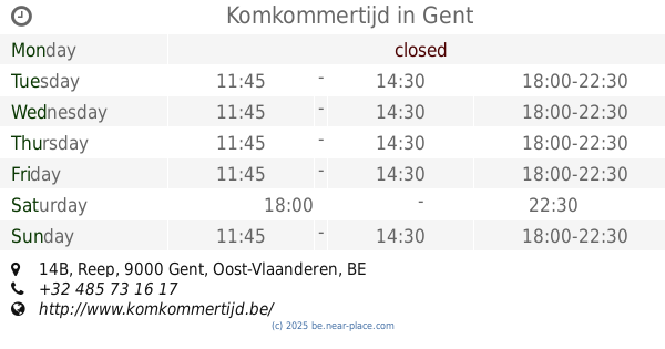
Cucumber Time
Reep 14B, Gent
Restaurant
read more
757 m
Komkommertijd
Reep 14B, Gent
Restaurant
read more
758 m
Smulderke
Sint-Jacobsnieuwstraat 83, Gent
Restaurant
read more
790 m
Vandevoorde / Olivier
Steendam 20, Gent
Restaurant
read more
886 m
Holy Food Market
Beverhoutplein 15, Gent
Restaurant
read more
910 m
Bari
Brabantdam 103, Gent
Restaurant
read more
927 m
Rasoi Indian Restaurant
Vlaanderenstraat 49, Gent
Restaurant
read more
932 m
La Resistenza Bvba
Brabantdam 82, Gent
Restaurant
read more
968 m
Fithap Gent
Vlaanderenstraat 113, Gent
Restaurant
read more
975 m
Yaki Noodle
Vlaanderenstraat 115, Gent
Restaurant
read more
983 m
Seli's Noodlebar
Limburgstraat 28, Gent
Restaurant
read more
1.01 km
wraps&soups
64, Lange Violettestraat, Gent
Restaurant
read more
1.051 km
Foodstorms
Graaf van Vlaanderenplein 40, Gent
Restaurant
read more
1.107 km
Pastinaak (De)
Achterstraat 124, Gent
Restaurant
read more
1.167 km
Ankara
Sleepstraat, Gent
Restaurant
read more
1.22 km
Tasty World
Walpoortstraat 38, Gent
Restaurant
read more
1.281 km
Muday - Taste of Ethiopia
Sint-Salvatorstraat 53, Gent
Restaurant
read more
📑
all categories
Accounting
Administrative area level 1
Administrative area level 2
Airport
Amusement park
Aquarium
Art gallery
Atm
Bakery
Bank
Bar
Beauty salon
Bicycle store
Book store
Bowling alley
Bus station
Cafe
Campground
Car dealer
Car rental
Car repair
Car wash
Casino
Cemetery
Church
City hall
Clothing store
Colloquial area
Convenience store
Country
Courthouse
Dentist
Department store
Doctor
Electrician
Electronics store
Embassy
Finance
Fire station
Florist
Food
Funeral home
Furniture store
Gas station
General contractor
Grocery or supermarket
Gym
Hair care
Hardware store
Health
Hindu Temple
Home goods store
Hospital
Insurance agency
Jewelry store
Laundry
Lawyer
Library
Light rail station
Liquor store
Local government office
Locality
Locksmith
Lodging
Meal delivery
Meal takeaway
Mosque
Movie rental
Movie theater
Moving company
Museum
Natural feature
Neighborhood
Night club
Painter
Park
Parking
Pet store
Pharmacy
Physiotherapist
Place of worship
Plumber
Point of interest
Police
Political
Post office
Premise
Real estate agency
Restaurant
Roofing contractor
Route
Rv park, camping
School
Shoe store
Shopping mall
Spa
Stadium
Storage
Store
Subpremise
Subway station
Supermarket
Synagogue
Taxi stand
Train station
Transit station
Travel agency
University
Veterinary care
Zoo
sublocality level 1
sublocality level 2
sublocality level 3
↑