Restaurant nearby Börek & Simit Huis
Coronavirus disease (COVID-19) Situation
confirmed cases
4861695
deaths
34376
Belgium
Restaurant nearby Börek & Simit Huis
Börek & Simit Huis
Dendermondsesteenweg 155, Gent Belgium
contacts phone
:
+32
Latitude:
51.0535686
, Longitude:
3.7441774
read more
nearest Restaurant
7 m
Polka
Dendermondsesteenweg 146, Gent
Restaurant
read more
147 m
Konya Etli Ekmek Salonu
Dendermondsesteenweg 106, Gent
Restaurant
read more
240 m
Gürcan Kebab
Dendermondsesteenweg 232, Gent
Restaurant
read more
318 m
Kebap 32
Dendermondsesteenweg 281, Gent
Restaurant
read more
388 m
Melita
Pilorijnstraat 18, Gent
Restaurant
read more
393 m
Pitta Gül
Dendermondsesteenweg 4, Gent
Restaurant
read more
503 m
Pan / Jnwei
Antwerpsesteenweg 5, Gent
Restaurant
read more
671 m
Ramenbar Golden Gai
Dampoortstraat 11, Gent
Restaurant
read more
689 m
Breadfast
Visserij 77, Gent
Restaurant
read more
926 m
Taverne Dynasty
Oude Beestenmarkt 3, Gent
Restaurant
read more
965 m
Cucumber Time
Reep 14B, Gent
Restaurant
read more
965 m
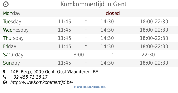
Komkommertijd
Reep 14B, Gent
Restaurant
read more
976 m
wraps&soups
64, Lange Violettestraat, Gent
Restaurant
read more
992 m
Bari
Brabantdam 103, Gent
Restaurant
read more
1.019 km
La Resistenza Bvba
Brabantdam 82, Gent
Restaurant
read more
1.032 km
Fithap Gent
Vlaanderenstraat 113, Gent
Restaurant
read more
1.039 km
Yaki Noodle
Vlaanderenstraat 115, Gent
Restaurant
read more
1.042 km
Ferrara Italiaans Eethuis
Vlaanderenstraat 127, Gent
Restaurant
read more
1.047 km
Edgar kaasbar
Steendam 62, Gent
Restaurant
read more
1.064 km
Foodstorms
Graaf van Vlaanderenplein 40, Gent
Restaurant
read more
1.073 km
ENTR
Ham 147, Gent
Restaurant
read more
1.111 km
Fonda
Graaf van Vlaanderenplein 40, Gent
Restaurant
read more
1.111 km
FONDA I tafel & toog POP-UP
Graaf van Vlaanderenplein 40, Gent
Restaurant
read more
1.129 km
'T5 HOEKSKE snackbar
Bloemistenstraat 23, Gent
Restaurant
read more
1.255 km
Kjure
Odilon Vanderlindenstraat 2, Gent
Restaurant
read more
📑
all categories
Accounting
Administrative area level 1
Administrative area level 2
Airport
Amusement park
Aquarium
Art gallery
Atm
Bakery
Bank
Bar
Beauty salon
Bicycle store
Book store
Bowling alley
Bus station
Cafe
Campground
Car dealer
Car rental
Car repair
Car wash
Casino
Cemetery
Church
City hall
Clothing store
Colloquial area
Convenience store
Country
Courthouse
Dentist
Department store
Doctor
Electrician
Electronics store
Embassy
Finance
Fire station
Florist
Food
Funeral home
Furniture store
Gas station
General contractor
Grocery or supermarket
Gym
Hair care
Hardware store
Health
Hindu Temple
Home goods store
Hospital
Insurance agency
Jewelry store
Laundry
Lawyer
Library
Light rail station
Liquor store
Local government office
Locality
Locksmith
Lodging
Meal delivery
Meal takeaway
Mosque
Movie rental
Movie theater
Moving company
Museum
Natural feature
Neighborhood
Night club
Painter
Park
Parking
Pet store
Pharmacy
Physiotherapist
Place of worship
Plumber
Point of interest
Police
Political
Post office
Premise
Real estate agency
Restaurant
Roofing contractor
Route
Rv park, camping
School
Shoe store
Shopping mall
Spa
Stadium
Storage
Store
Subpremise
Subway station
Supermarket
Synagogue
Taxi stand
Train station
Transit station
Travel agency
University
Veterinary care
Zoo
sublocality level 1
sublocality level 2
sublocality level 3
↑