Gas station nearby Total
Belgium
Gas station nearby Total
Total
Dendermondse Steenweg 67, Berlare Belgium
contacts phone
:
+32
Latitude:
51.0502813
, Longitude:
3.9745706
read more
nearest Gas station
1.524 km
Esso
Gentsesteenweg 289, Zele
Gas station
read more
2.942 km
Texaco service Station
Dendermondsesteenweg 100, Laarne
Gas station
read more
3.248 km
Gabriëls Zele
Gentsesteenweg 135, Zele
Gas station
read more
3.625 km
AVIA Berlare
Dorp 72, Berlare
Gas station
read more
4.381 km
Total Kalken E17 richting Antwerpen
E17 Gent-Antwerpen, Laarne
Gas station
read more
4.381 km
Total
E17 Gent-Antwerpen, Laarne
Gas station
read more
4.386 km
Texaco
Emiel Hertecantlaan 40, Berlare
Gas station
read more
4.433 km
Total
E17 Antwerpen-gent, Laarne
Gas station
read more
4.44 km
Total
Gent, E17 Antwerpen, Laarne
Gas station
read more
4.674 km
VdB ENERGIE
Moleken 16, Wichelen
Gas station
read more
4.742 km
AVIA Heiende
Hillarestraat 123-129, Lokeren
Gas station
read more
5.415 km
Texaco
Zelebaan 91, Lokeren
Gas station
read more
5.434 km
tankpool24
Zelebaan 91, Lokeren
Gas station
read more
5.552 km
Q8
Zelebaan 33, Lokeren
Gas station
read more
5.569 km
AVIA N47-Zelebaan (zuid)
Zelebaan 25, Lokeren
Gas station
read more
5.569 km
Total
Zelebaan 39-41, Lokeren
Gas station
read more
5.589 km
Dats24 Lokeren
Zelebaan 100, Lokeren
Gas station
read more
5.733 km
Gulf
Eegene 148, Dendermonde
Gas station
read more
5.774 km
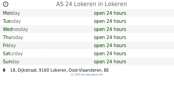
AS 24 Lokeren
Dijkstraat 18, Lokeren
Gas station
read more
5.775 km
AS24
Dijkstraat, Lokeren
Gas station
read more
5.776 km
Bel Lokeren AS24
9160, Lokeren
Gas station
read more
5.901 km
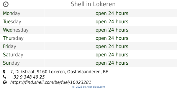
Shell
Dijkstraat 7, Lokeren
Gas station
read more
6.66 km
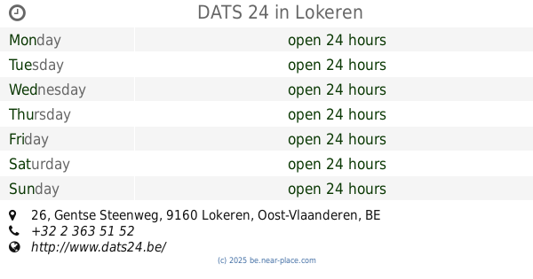
DATS 24
Gentse Steenweg 26, Lokeren
Gas station
read more
12.984 km
Total
Brusselsesteenweg 314, Melle
Gas station
read more
14.912 km
Lukoil Gentbrugge
Brusselsesteenweg 679, Gentbrugge
Gas station
read more
📑
all categories
Accounting
Administrative area level 1
Administrative area level 2
Airport
Amusement park
Aquarium
Art gallery
Atm
Bakery
Bank
Bar
Beauty salon
Bicycle store
Book store
Bowling alley
Bus station
Cafe
Campground
Car dealer
Car rental
Car repair
Car wash
Casino
Cemetery
Church
City hall
Clothing store
Colloquial area
Convenience store
Country
Courthouse
Dentist
Department store
Doctor
Electrician
Electronics store
Embassy
Finance
Fire station
Florist
Food
Funeral home
Furniture store
Gas station
General contractor
Grocery or supermarket
Gym
Hair care
Hardware store
Health
Hindu Temple
Home goods store
Hospital
Insurance agency
Jewelry store
Laundry
Lawyer
Library
Light rail station
Liquor store
Local government office
Locality
Locksmith
Lodging
Meal delivery
Meal takeaway
Mosque
Movie rental
Movie theater
Moving company
Museum
Natural feature
Neighborhood
Night club
Painter
Park
Parking
Pet store
Pharmacy
Physiotherapist
Place of worship
Plumber
Point of interest
Police
Political
Post office
Premise
Real estate agency
Restaurant
Roofing contractor
Route
Rv park, camping
School
Shoe store
Shopping mall
Spa
Stadium
Storage
Store
Subpremise
Subway station
Supermarket
Synagogue
Taxi stand
Train station
Transit station
Travel agency
University
Veterinary care
Zoo
sublocality level 1
sublocality level 2
sublocality level 3
↑