Gas station nearby Total
Belgium
Gas station nearby Total
Total
Brusselsesteenweg 314, Melle Belgien
contacts phone
:
+32
Latitude:
50.9996563
, Longitude:
3.807258
read more
nearest Gas station
881 m
Esso
Brusselsesteenweg,485, Melle
Gas station
read more
2.362 km
Power
Brusselsesteenweg 126, Melle
Gas station
read more
3.098 km
DATS 24
Brusselsesteenweg 252, Wetteren
Gas station
read more
3.139 km
Shell
Zuidlaan 296, Wetteren
Gas station
read more
3.14 km
Desimpel - Wetteren
Oosterzelesteenweg 61, Wetteren
Gas station
read more
3.151 km
AVIA
Oosterzelesteenweg 65, Wetteren
Gas station
read more
3.16 km
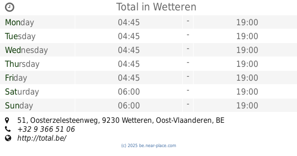
Total
Oosterzelesteenweg 51, Wetteren
Gas station
read more
3.172 km
Gabriel Merelbeke
Guldensporenlaan 9, Merelbeke
Gas station
read more
3.172 km
Gabriëls
Guldensporenlaan 9, Merelbeke
Gas station
read more
3.179 km
Wetteren Maes
Brusselsesteenweg 256, Wetteren
Gas station
read more
3.411 km
DATS 24
Brusselsesteenweg 36, Melle
Gas station
read more
3.684 km
Desimpel
Laarnebaan 1, Destelbergen
Gas station
read more
4.034 km
Shell
A10, Wetteren
Gas station
read more
4.044 km
Texaco
Eekhoekstraat 19, Laarne
Gas station
read more
4.139 km
Esso
Hundelgemsesteenweg 283, Merelbeke
Gas station
read more
4.205 km
Shell
E40, Gent
Gas station
read more
4.572 km
Total
Hundelgemsesteenweg 471, Gent
Gas station
read more
4.609 km
Lukoil Gentbrugge
Brusselsesteenweg 679, Gentbrugge
Gas station
read more
5.013 km
Texaco
Hundelgemsesteenweg 635, Merelbeke
Gas station
read more
5.064 km
Total
Nieuwe Brug 1, Wetteren
Gas station
read more
5.064 km
Total - Overschelde DEWI RETAIL BVBA
Nieuwe Brug 1, Wetteren
Gas station
read more
5.147 km
Desimpel - Gentbrugge
Hundelgemsesteenweg 319, Gent
Gas station
read more
5.777 km
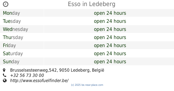
Esso
Brusselsesteenweg,542, Ledeberg
Gas station
read more
5.868 km
Q8
Brusselsesteenweg 335, Gent-Gentbrugge
Gas station
read more
5.921 km
Shell
Koningin Astridlaan 48, Merelbeke
Gas station
read more
📑
all categories
Accounting
Administrative area level 1
Administrative area level 2
Airport
Amusement park
Aquarium
Art gallery
Atm
Bakery
Bank
Bar
Beauty salon
Bicycle store
Book store
Bowling alley
Bus station
Cafe
Campground
Car dealer
Car rental
Car repair
Car wash
Casino
Cemetery
Church
City hall
Clothing store
Colloquial area
Convenience store
Country
Courthouse
Dentist
Department store
Doctor
Electrician
Electronics store
Embassy
Finance
Fire station
Florist
Food
Funeral home
Furniture store
Gas station
General contractor
Grocery or supermarket
Gym
Hair care
Hardware store
Health
Hindu Temple
Home goods store
Hospital
Insurance agency
Jewelry store
Laundry
Lawyer
Library
Light rail station
Liquor store
Local government office
Locality
Locksmith
Lodging
Meal delivery
Meal takeaway
Mosque
Movie rental
Movie theater
Moving company
Museum
Natural feature
Neighborhood
Night club
Painter
Park
Parking
Pet store
Pharmacy
Physiotherapist
Place of worship
Plumber
Point of interest
Police
Political
Post office
Premise
Real estate agency
Restaurant
Roofing contractor
Route
Rv park, camping
School
Shoe store
Shopping mall
Spa
Stadium
Storage
Store
Subpremise
Subway station
Supermarket
Synagogue
Taxi stand
Train station
Transit station
Travel agency
University
Veterinary care
Zoo
sublocality level 1
sublocality level 2
sublocality level 3
↑