Gas station nearby Rasschaert
Belgium
Gas station nearby Rasschaert
Rasschaert
Wetterensteenweg 5, Wichelen Belgium
contacts phone
:
+32
Latitude:
50.992866
, Longitude:
3.920596
read more
nearest Gas station
29 m
Power
Wetterensteenweg 5, Wichelen
Gas station
read more
2.264 km
Carwash-Benzine station
Warandelaan 12, Wetteren
Gas station
read more
3.464 km
TOTAL Tankstelle
Nieuwe Brug 1, Wetteren
Gas station
read more
3.464 km
Total
Nieuwe Brug 1, Wetteren
Gas station
read more
3.464 km
Total - Overschelde DEWI RETAIL BVBA
Nieuwe Brug 1, Wetteren
Gas station
read more
3.738 km
VdB ENERGIE
Moleken 16, Wichelen
Gas station
read more
3.753 km
Vera Gas
Peperstraat 7, Wetteren
Gas station
read more
4.248 km
Tankstation Power
Grote Steenweg 193, Lede
Gas station
read more
4.255 km
Gabriëls Oordegem - Kennof
Grote Steenweg 284, Lede
Gas station
read more
4.732 km
Power - Lede
Grote Steenweg 346, Lede
Gas station
read more
4.832 km
Shell Wetteren E40 Richting Gent
Gentsesteenweg 25, Lede
Gas station
read more
5.51 km
Texaco
Hoogstraat 115, Lede
Gas station
read more
5.714 km
Total
Lange Meire 54, Laarne
Gas station
read more
6.008 km
Gabriëls
Leedsesteenweg 196, Erpe
Gas station
read more
7.967 km
Total
Brusselsesteenweg 314, Melle
Gas station
read more
8.576 km
Total
E17 Gent-Antwerpen, Laarne
Gas station
read more
10.291 km
Texaco
Huytstraat 2, Haaltert
Gas station
read more
11.762 km
Lukoil Gentbrugge
Brusselsesteenweg 679, Gentbrugge
Gas station
read more
12.068 km
Esso
Hundelgemsesteenweg 283, Merelbeke
Gas station
read more
13.406 km
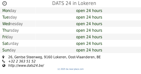
DATS 24
Gentse Steenweg 26, Lokeren
Gas station
read more
14.035 km
Q8 Service Stations
Corneel Heymanslaan 9, Gent
Gas station
read more
14.04 km
Lukoil Lokeren
Bergendriesstraat 75, Lokeren
Gas station
read more
14.496 km
Gabriëls
Brusselbaan 290, Erembodegem
Gas station
read more
15.769 km
Vrij/Libre - Bvba Garage Gebr Everaert - Meldert
Molenstraat 62, Affligem
Gas station
read more
17.595 km
Q8 easy
Bellestraat 146, Affligem
Gas station
read more
📑
all categories
Accounting
Administrative area level 1
Administrative area level 2
Airport
Amusement park
Aquarium
Art gallery
Atm
Bakery
Bank
Bar
Beauty salon
Bicycle store
Book store
Bowling alley
Bus station
Cafe
Campground
Car dealer
Car rental
Car repair
Car wash
Casino
Cemetery
Church
City hall
Clothing store
Colloquial area
Convenience store
Country
Courthouse
Dentist
Department store
Doctor
Electrician
Electronics store
Embassy
Finance
Fire station
Florist
Food
Funeral home
Furniture store
Gas station
General contractor
Grocery or supermarket
Gym
Hair care
Hardware store
Health
Hindu Temple
Home goods store
Hospital
Insurance agency
Jewelry store
Laundry
Lawyer
Library
Light rail station
Liquor store
Local government office
Locality
Locksmith
Lodging
Meal delivery
Meal takeaway
Mosque
Movie rental
Movie theater
Moving company
Museum
Natural feature
Neighborhood
Night club
Painter
Park
Parking
Pet store
Pharmacy
Physiotherapist
Place of worship
Plumber
Point of interest
Police
Political
Post office
Premise
Real estate agency
Restaurant
Roofing contractor
Route
Rv park, camping
School
Shoe store
Shopping mall
Spa
Stadium
Storage
Store
Subpremise
Subway station
Supermarket
Synagogue
Taxi stand
Train station
Transit station
Travel agency
University
Veterinary care
Zoo
sublocality level 1
sublocality level 2
sublocality level 3
↑