Cafe nearby Sportlokaal
Belgium
Cafe nearby Sportlokaal
Sportlokaal
Keulenstraat 19, Herent Belgium
contacts phone
:
+32
Latitude:
50.9232946
, Longitude:
4.690318
read more
nearest Cafe
Schoevaerts / R.
Keulenstraat 19, Herent
Cafe
read more
884 m
Het Werrek
Sint-Hadrianusstraat 1, Wijgmaal
Cafe
read more
2.107 km
Eet- en praatcafé De Wildeman
Schoolstraat 13, Herent
Cafe
read more
2.382 km
Onder De Toren
Aarschotsesteenweg 531, Wilsele
Cafe
read more
2.386 km
Frituur Fantasia
403, Mechelsesteenweg, Herent
Cafe
read more
2.434 km
Den Travoo
O.l.vrouwstraat 2, Herent
Cafe
read more
2.462 km
Coenye / Marie
Aarschotsesteenweg 768, Wilsele
Cafe
read more
2.562 km
Tveldeke
Klein Langeveld 30, Holsbeek
Cafe
read more
3.41 km
Cafe De Zijbeuk
Dorpsplein 1, Rotselaar
Cafe
read more
3.432 km
Herberg 't Huis
Provinciebaan 18, Rotselaar
Cafe
read more
4.092 km
bjurn's teahouse
Kloosterdreef 3-61, Rotselaar
Cafe
read more
4.104 km
Costrop / Marc
Vaartkom 18, Leuven
Cafe
read more
4.709 km
Optimist
Vismarkt 7, Leuven
Cafe
read more
4.736 km
Zonnekompas
Brusselsestraat 146, Leuven
Cafe
read more
4.76 km
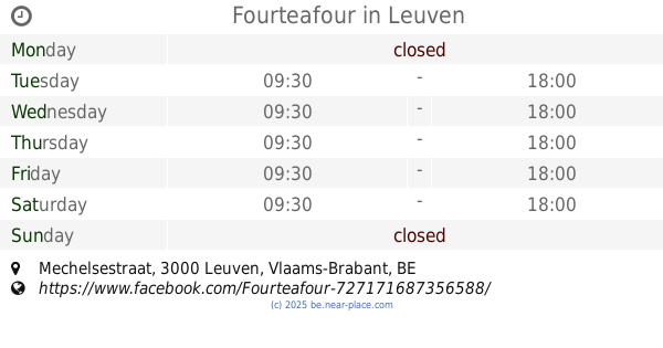
Fourteafour
Mechelsestraat, Leuven
Cafe
read more
4.843 km
MOK Specialty Coffee Roastery & Bar
Diestsestraat 165, Leuven
Cafe
read more
4.86 km
Belgaleiro
Goudsbloemstraat 50, Leuven
Cafe
read more
4.936 km
Mon Martre
Parijsstraat 6, Leuven
Cafe
read more
5.011 km
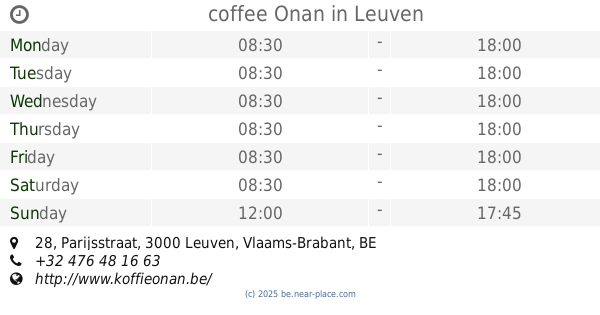
coffee Onan
Parijsstraat 28, Leuven
Cafe
read more
5.02 km
Het Schild Van Loven
Oude Markt 4, Leuven
Cafe
read more
5.021 km
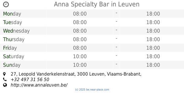
Anna Specialty Bar
Leopold Vanderkelenstraat 27, Leuven
Cafe
read more
5.074 km
Hete Mie - Kouwe Jef
Monseigneur Ladeuzeplein 15, Leuven
Cafe
read more
5.191 km
Cafetaria Ivo Van Damme
Overstraat 21, Herent
Cafe
read more
5.207 km
Hemelaers / Eric
Schoolbergenstraat 218, Leuven
Cafe
read more
5.442 km
Pinxtermolen
Diestsesteenweg 480, Leuven
Cafe
read more
📑
all categories
Accounting
Administrative area level 1
Administrative area level 2
Airport
Amusement park
Aquarium
Art gallery
Atm
Bakery
Bank
Bar
Beauty salon
Bicycle store
Book store
Bowling alley
Bus station
Cafe
Campground
Car dealer
Car rental
Car repair
Car wash
Casino
Cemetery
Church
City hall
Clothing store
Colloquial area
Convenience store
Country
Courthouse
Dentist
Department store
Doctor
Electrician
Electronics store
Embassy
Finance
Fire station
Florist
Food
Funeral home
Furniture store
Gas station
General contractor
Grocery or supermarket
Gym
Hair care
Hardware store
Health
Hindu Temple
Home goods store
Hospital
Insurance agency
Jewelry store
Laundry
Lawyer
Library
Light rail station
Liquor store
Local government office
Locality
Locksmith
Lodging
Meal delivery
Meal takeaway
Mosque
Movie rental
Movie theater
Moving company
Museum
Natural feature
Neighborhood
Night club
Painter
Park
Parking
Pet store
Pharmacy
Physiotherapist
Place of worship
Plumber
Point of interest
Police
Political
Post office
Premise
Real estate agency
Restaurant
Roofing contractor
Route
Rv park, camping
School
Shoe store
Shopping mall
Spa
Stadium
Storage
Store
Subpremise
Subway station
Supermarket
Synagogue
Taxi stand
Train station
Transit station
Travel agency
University
Veterinary care
Zoo
sublocality level 1
sublocality level 2
sublocality level 3
↑