Cafe nearby Eet- en praatcafé De Wildeman
Belgium
Cafe nearby Eet- en praatcafé De Wildeman
Eet- en praatcafé De Wildeman
Schoolstraat 13, Herent Belgia
contacts phone
:
+32
Latitude:
50.906493
, Longitude:
4.676406
read more
nearest Cafe
329 m
Den Travoo
O.l.vrouwstraat 2, Herent
Cafe
read more
347 m
Frituur Fantasia
403, Mechelsesteenweg, Herent
Cafe
read more
2.107 km
Schoevaerts / R.
Keulenstraat 19, Herent
Cafe
read more
2.107 km
Sportlokaal
Keulenstraat 19, Herent
Cafe
read more
2.661 km
maes(kantje)
Valkerijgang 4, Leuven
Cafe
read more
2.739 km
Coupe Matadi
Kolonel Begaultlaan 7,
[email protected]
, Leuven
Cafe
read more
2.819 km
Costrop / Marc
Vaartkom 18, Leuven
Cafe
read more
2.838 km
ROM Coffee & More
10, Sluisstraat, Leuven
Cafe
read more
3.098 km
Zonnekompas
Brusselsestraat 146, Leuven
Cafe
read more
3.121 km
Belgaleiro
Goudsbloemstraat 50, Leuven
Cafe
read more
3.196 km
café aan de zatte toog
Vaartstraat 43, Leuven
Cafe
read more
3.215 km
De Nieuwe Blauwe Kater
Mechelsestraat 51, Leuven
Cafe
read more
3.247 km
Optimist
Vismarkt 7, Leuven
Cafe
read more
3.277 km
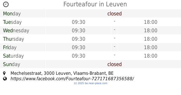
Fourteafour
Mechelsestraat, Leuven
Cafe
read more
3.493 km
Literair Café Van de Velde Twee Bronnen
Diestsestraat 49, Leuven
Cafe
read more
3.506 km
Getaway
Vital Decosterstraat 26-54, Leuven
Cafe
read more
3.611 km
café2go
Diestsestraat 122, Leuven
Cafe
read more
3.629 km
MOK Specialty Coffee Roastery & Bar
Diestsestraat 165, Leuven
Cafe
read more
3.658 km
Pardon / Luc
Louis Melsensstraat 12, Leuven
Cafe
read more
3.678 km
Toewip
Diestsestraat 182, Leuven
Cafe
read more
3.816 km
Brasserie National
Tiensevest 20, Leuven
Cafe
read more
3.836 km
Cafe de la gare
Martelarenplein 15, Leuven
Cafe
read more
3.853 km
Grand Café Industrie
Martelarenplein 7, Leuven
Cafe
read more
3.906 km
Starbucks
Martelarenplein 16, Leuven
Cafe
read more
3.93 km
Café Marie Thérèse
Martelarenplein 1, Leuven
Cafe
read more
📑
all categories
Accounting
Administrative area level 1
Administrative area level 2
Airport
Amusement park
Aquarium
Art gallery
Atm
Bakery
Bank
Bar
Beauty salon
Bicycle store
Book store
Bowling alley
Bus station
Cafe
Campground
Car dealer
Car rental
Car repair
Car wash
Casino
Cemetery
Church
City hall
Clothing store
Colloquial area
Convenience store
Country
Courthouse
Dentist
Department store
Doctor
Electrician
Electronics store
Embassy
Finance
Fire station
Florist
Food
Funeral home
Furniture store
Gas station
General contractor
Grocery or supermarket
Gym
Hair care
Hardware store
Health
Hindu Temple
Home goods store
Hospital
Insurance agency
Jewelry store
Laundry
Lawyer
Library
Light rail station
Liquor store
Local government office
Locality
Locksmith
Lodging
Meal delivery
Meal takeaway
Mosque
Movie rental
Movie theater
Moving company
Museum
Natural feature
Neighborhood
Night club
Painter
Park
Parking
Pet store
Pharmacy
Physiotherapist
Place of worship
Plumber
Point of interest
Police
Political
Post office
Premise
Real estate agency
Restaurant
Roofing contractor
Route
Rv park, camping
School
Shoe store
Shopping mall
Spa
Stadium
Storage
Store
Subpremise
Subway station
Supermarket
Synagogue
Taxi stand
Train station
Transit station
Travel agency
University
Veterinary care
Zoo
sublocality level 1
sublocality level 2
sublocality level 3
↑