Bar nearby Wijnbar Violette
Coronavirus disease (COVID-19) Situation
confirmed cases
4861695
deaths
34376
Belgium
Bar nearby Wijnbar Violette
Wijnbar Violette
12, Grote Markt, 3290, Diest, Vlaams-Brabant, BE Bélgica
contacts phone
:
+32 477 63 51 61
website:
www.facebook.com
Latitude:
50.9845087
, Longitude:
5.0508698
larger map & directions
read more
nearest Bar
38 m
Eglantier
Grote Markt 16, Diest
Bar
read more
217 m
Szegediek
Kardinaal Mercierstraat, Diest
Bar
read more
221 m
Den Arend
Koning Albertstraat 35, Diest
Bar
read more
225 m
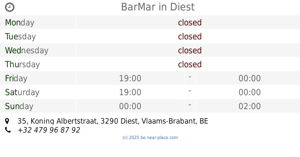
BarMar
Koning Albertstraat 35, Diest
Bar
read more
441 m
Loterbol
3290, Michel Theysstraat 58, Diest
Bar
read more
510 m
The Garage
Koning Albertstraat 104, Diest
Bar
read more
700 m
Orient Diest - Pizzeria - Kebab - Grill
Delphine Alenuslaan 39, Diest
Bar
read more
2.623 km
gsm ionut nitu constantin
Diestsebaan 31, Diest
Bar
read more
3.966 km
Club Orchidee
Staatsbaan 43, Bekkevoort
Bar
read more
4.855 km
Café Heren van Zichem
Markt 39, Scherpenheuvel-Zichem
Bar
read more
4.924 km
Railz
Ernest Claesstraat 73, Scherpenheuvel-Zichem
Bar
read more
5.077 km
Oan't Fontainke
Prattenborgplein 9, Scherpenheuvel-Zichem
Bar
read more
5.728 km
De Singel D.c. Bvba
Singellaan 22, Halen
Bar
read more
6.004 km
De 12e XII Oogst
Markt 1, Halen
Bar
read more
6.021 km
Place Douze
Markt 12, Halen
Bar
read more
6.241 km
Acanthys club
N2, Kortenberg
Bar
read more
10.628 km
Beutels / Louisa
Sint-Janstraat 41, Beringen
Bar
read more
11.246 km
Brewhouse Karbo
Oude Geelsebaan 102, Laakdal
Bar
read more
13.999 km
The Corner
Markt 22, Beringen
Bar
read more
14.173 km
Jeugdhuis Bunker vzw
Grotestraat 29, Glabbeek
Bar
read more
14.26 km
Goede Vrijdag
Sint-Servaasweg 1, Herselt
Bar
read more
15.002 km
Baobab Beach Club
De Merodedreef 189, Westerlo
Bar
read more
15.863 km
Chef Todos / Foodtruck Tapas/Streetfood on Wheels
Steenkoolwijk 10, Ham
Bar
read more
15.911 km
Café 't Dorp
Heldenplein 49, Ham
Bar
read more
15.945 km
Café Torenzicht
Heldenplein 27, Ham
Bar
read more
📑
all categories
Accounting
Administrative area level 1
Administrative area level 2
Airport
Amusement park
Aquarium
Art gallery
Atm
Bakery
Bank
Bar
Beauty salon
Bicycle store
Book store
Bowling alley
Bus station
Cafe
Campground
Car dealer
Car rental
Car repair
Car wash
Casino
Cemetery
Church
City hall
Clothing store
Colloquial area
Convenience store
Country
Courthouse
Dentist
Department store
Doctor
Electrician
Electronics store
Embassy
Finance
Fire station
Florist
Food
Funeral home
Furniture store
Gas station
General contractor
Grocery or supermarket
Gym
Hair care
Hardware store
Health
Hindu Temple
Home goods store
Hospital
Insurance agency
Jewelry store
Laundry
Lawyer
Library
Light rail station
Liquor store
Local government office
Locality
Locksmith
Lodging
Meal delivery
Meal takeaway
Mosque
Movie rental
Movie theater
Moving company
Museum
Natural feature
Neighborhood
Night club
Painter
Park
Parking
Pet store
Pharmacy
Physiotherapist
Place of worship
Plumber
Point of interest
Police
Political
Post office
Premise
Real estate agency
Restaurant
Roofing contractor
Route
Rv park, camping
School
Shoe store
Shopping mall
Spa
Stadium
Storage
Store
Subpremise
Subway station
Supermarket
Synagogue
Taxi stand
Train station
Transit station
Travel agency
University
Veterinary care
Zoo
sublocality level 1
sublocality level 2
sublocality level 3
↑