Bar nearby The Corner
Belgium
Bar nearby The Corner
The Corner
Markt 22, Beringen Belgien
contacts phone
:
+32
Latitude:
51.0476993
, Longitude:
5.2239815
read more
nearest Bar
2.178 km
DJ / Discobar 2 maal fout
Pater Beckersstraat, Eversel
Bar
read more
2.35 km
Café Getaway's
36,, N717 16, Lummen
Bar
read more
2.963 km
Remise 56
Albert I laan 56, Beringen
Bar
read more
3.011 km
IVBIF Beringen
Noordwijkstraat 13, Beringen
Bar
read more
3.069 km
Poolse Vrije Vereniging, Beringen
Laan op Vurten 83, Beringen
Bar
read more
3.455 km
Beutels / Louisa
Sint-Janstraat 41, Beringen
Bar
read more
3.538 km
't Bierhuis
Pieter Vanhoudtstraat 64a, Beringen
Bar
read more
3.599 km
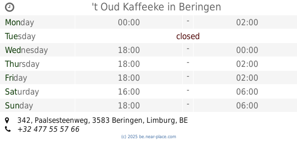
't Oud Kaffeeke
Paalsesteenweg 342, Beringen
Bar
read more
3.708 km
café 't centrum
Heldenlaan 1, Paal
Bar
read more
4.006 km
Jeugdhuis Club 9 vzw
Pastorijstraat 44, Beringen
Bar
read more
4.164 km
Havana Cafe
Kooidries 4, Heusden-Zolder
Bar
read more
4.317 km
JH De Distel
Pastoor van Mierlolaan 19, Heusden-Zolder
Bar
read more
5.328 km
De Bungalow Vzw Vzw
Larenstraat 117, Lummen
Bar
read more
7.34 km
Chef Todos / Foodtruck Tapas/Streetfood on Wheels
Steenkoolwijk 10, Ham
Bar
read more
11.901 km
Tropical
Heuvenstraat 5, Zonhoven
Bar
read more
13.51 km
Place Douze
Markt 12, Halen
Bar
read more
13.783 km
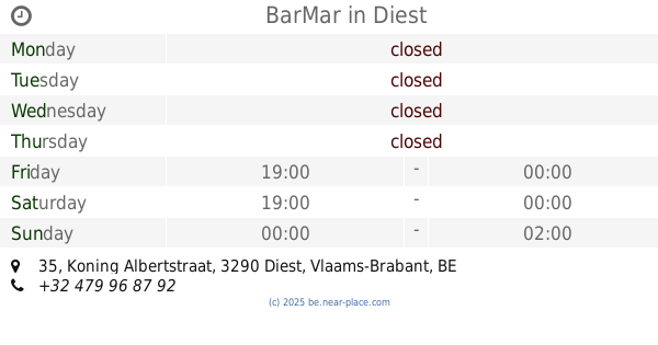
BarMar
Koning Albertstraat 35, Diest
Bar
read more
13.82 km
De Kroon
Markt 19, Meerhout
Bar
read more
14.064 km
Szegediek
Kardinaal Mercierstraat, Diest
Bar
read more
15.126 km
Marloo's
Minderbroedersstraat 5, Hasselt
Bar
read more
15.132 km
El Bocado
Dokter Willemsstraat 10, Hasselt
Bar
read more
15.293 km
L'aperi Vino
Zuivelmarkt 20, Hasselt
Bar
read more
17.826 km
Club Orchidee
Staatsbaan 43, Bekkevoort
Bar
read more
18.135 km
Pasion y Sabor
Havenlaan 71, Diepenbeek
Bar
read more
20.11 km
De Ballasthoeve
Ballaststraat 75, Overpelt
Bar
read more
📑
all categories
Accounting
Administrative area level 1
Administrative area level 2
Airport
Amusement park
Aquarium
Art gallery
Atm
Bakery
Bank
Bar
Beauty salon
Bicycle store
Book store
Bowling alley
Bus station
Cafe
Campground
Car dealer
Car rental
Car repair
Car wash
Casino
Cemetery
Church
City hall
Clothing store
Colloquial area
Convenience store
Country
Courthouse
Dentist
Department store
Doctor
Electrician
Electronics store
Embassy
Finance
Fire station
Florist
Food
Funeral home
Furniture store
Gas station
General contractor
Grocery or supermarket
Gym
Hair care
Hardware store
Health
Hindu Temple
Home goods store
Hospital
Insurance agency
Jewelry store
Laundry
Lawyer
Library
Light rail station
Liquor store
Local government office
Locality
Locksmith
Lodging
Meal delivery
Meal takeaway
Mosque
Movie rental
Movie theater
Moving company
Museum
Natural feature
Neighborhood
Night club
Painter
Park
Parking
Pet store
Pharmacy
Physiotherapist
Place of worship
Plumber
Point of interest
Police
Political
Post office
Premise
Real estate agency
Restaurant
Roofing contractor
Route
Rv park, camping
School
Shoe store
Shopping mall
Spa
Stadium
Storage
Store
Subpremise
Subway station
Supermarket
Synagogue
Taxi stand
Train station
Transit station
Travel agency
University
Veterinary care
Zoo
sublocality level 1
sublocality level 2
sublocality level 3
↑