Supermarket nearby Hema
Belgium
Supermarket nearby Hema
Hema
Kortrijkstraat 8-10, Tielt Belgique
contacts phone
:
+32
Latitude:
50.9996034
, Longitude:
3.3264207
read more
nearest Supermarket
164 m
Supermarket De Weerdt
Kortrijkstraat 56, Tielt
Supermarket
read more
307 m
AD Tielt
Ieperstraat 63, Tielt
Supermarket
read more
656 m
Collect&Go Tielt
Deken Darraslaan 66, Tielt
Supermarket
read more
729 m
Colruyt Tielt
Deken Darraslaan 66, Tielt
Supermarket
read more
745 m
't Vershoekske
Beernegemstraat 43, Tielt
Supermarket
read more
926 m
ALDI Tielt
Stationsstraat 91, Tielt
Supermarket
read more
964 m
Carrefour market
Fonteinestraat 41, Tielt
Supermarket
read more
964 m
Soenens / Willy
Stationsplein 3, Tielt
Supermarket
read more
1.262 km
OKay Tielt
Gruuthusestraat 54, Tielt
Supermarket
read more
3.378 km
Sierens / Koen
Henri D'Hontstraat 72, Tielt
Supermarket
read more
4.149 km
De Fijnbek
Markt 12, Pittem
Supermarket
read more
4.402 km
Carrefour market
Broeders Maristenstraat 4, Pittem
Supermarket
read more
6.537 km
Drinkshop Huis Maria
Pensionaatstraat, Ruiselede
Supermarket
read more
6.543 km
Huis Maria
Kasteelstraat 32, Ruiselede
Supermarket
read more
6.805 km
SPAR Dentergem
Statiestraat 121, Dentergem
Supermarket
read more
9.762 km
AD Delhaize Ingelmunster
Bruggestraat 77, Ingelmunster
Supermarket
read more
9.836 km
Lidl
Bruggestraat 77/A, Ingelmunster
Supermarket
read more
11.209 km
Shop & Go Wielsbeke
Rijksweg 1, Wielsbeke
Supermarket
read more
12.258 km
AD Waregem
Gentseweg 602, Waregem
Supermarket
read more
12.365 km
ALDI Aalter
Lostraat 81, Aalter
Supermarket
read more
14.906 km
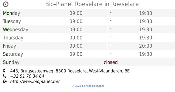
Bio-Planet Roeselare
Brugsesteenweg 443, Roeselare
Supermarket
read more
15.409 km
Sentemart
Heulsestraat 109/A, Lendelede
Supermarket
read more
16.25 km
Delhaize Roeselare
Westlaan 187, Roeselare
Supermarket
read more
17.899 km
Callemeyn / Filip
Gabriëlstraat 59, Roeselare
Supermarket
read more
18.037 km
Prima
Vrekkemstraat 7, Ursel
Supermarket
read more
📑
all categories
Accounting
Administrative area level 1
Administrative area level 2
Airport
Amusement park
Aquarium
Art gallery
Atm
Bakery
Bank
Bar
Beauty salon
Bicycle store
Book store
Bowling alley
Bus station
Cafe
Campground
Car dealer
Car rental
Car repair
Car wash
Casino
Cemetery
Church
City hall
Clothing store
Colloquial area
Convenience store
Country
Courthouse
Dentist
Department store
Doctor
Electrician
Electronics store
Embassy
Finance
Fire station
Florist
Food
Funeral home
Furniture store
Gas station
General contractor
Grocery or supermarket
Gym
Hair care
Hardware store
Health
Hindu Temple
Home goods store
Hospital
Insurance agency
Jewelry store
Laundry
Lawyer
Library
Light rail station
Liquor store
Local government office
Locality
Locksmith
Lodging
Meal delivery
Meal takeaway
Mosque
Movie rental
Movie theater
Moving company
Museum
Natural feature
Neighborhood
Night club
Painter
Park
Parking
Pet store
Pharmacy
Physiotherapist
Place of worship
Plumber
Point of interest
Police
Political
Post office
Premise
Real estate agency
Restaurant
Roofing contractor
Route
Rv park, camping
School
Shoe store
Shopping mall
Spa
Stadium
Storage
Store
Subpremise
Subway station
Supermarket
Synagogue
Taxi stand
Train station
Transit station
Travel agency
University
Veterinary care
Zoo
sublocality level 1
sublocality level 2
sublocality level 3
↑