Supermarket nearby Carrefour market
Belgium
Supermarket nearby Carrefour market
Carrefour market
Torhoutstraat 4, Kortemark Belgien
contacts phone
:
+32
Latitude:
51.0288803
, Longitude:
3.0443994
read more
nearest Supermarket
116 m
Verdema Tuinmachines
Lichterveldestraat 4, Kortemark
Supermarket
read more
2.758 km
Dedier Marleen
Rijksweg 45, Torhout
Supermarket
read more
5.223 km
Carrefour market
Stationsstraat 12, Gits
Supermarket
read more
5.333 km
Collect&Go Torhout
25 Kortemarkstraat, Torhout
Supermarket
read more
5.393 km
Colruyt Torhout
Kortemarkstraat 25, Torhout
Supermarket
read more
5.403 km
GB Carrefour Market
Oostendestraat 284, Torhout
Supermarket
read more
5.414 km
Carrefour market
Oostendestraat 284, Torhout
Supermarket
read more
5.669 km
Nachtwinkel
Gevangenisstraat, Torhout
Supermarket
read more
5.7 km
Carrefour market
Hofstraat 11, Torhout
Supermarket
read more
5.791 km
ALDI Torhout
Zwevezelestraat 16, Torhout
Supermarket
read more
6.134 km
Proxy Delhaize Zarren
Zarrenplein 1, Kortemark
Supermarket
read more
6.855 km
Proxy Delhaize Staden
Sint Jansstraat 110, Staden
Supermarket
read more
8.31 km
Mammoet 2001
Brugsesteenweg 500, Roeselare
Supermarket
read more
8.4 km
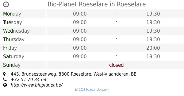
Bio-Planet Roeselare
Brugsesteenweg 443, Roeselare
Supermarket
read more
9.95 km
Proxy Delhaize Aartrijke
Aartrijksestraat 88, Zedelgem
Supermarket
read more
10.898 km
Delhaize Roeselare
Westlaan 187, Roeselare
Supermarket
read more
11.511 km
Vandamme - Vermeersch
Merkemstraat 11, Houthulst
Supermarket
read more
13.664 km
SPAR Poelkapelle
Nieuwplaats 1, Langemark-Poelkapelle
Supermarket
read more
14.155 km
Nachtwinkel Zedelgem
Groenestraat 3, Zedelgem
Supermarket
read more
16.168 km
Callemeyn / Filip
Gabriëlstraat 59, Roeselare
Supermarket
read more
16.664 km
SPAR Emelgem
Baronstraat 116, Izegem
Supermarket
read more
17.231 km
Okay Loppem
Heidelbergstraat 1, Zedelgem
Supermarket
read more
18.59 km
AD Delhaize Ingelmunster
Bruggestraat 77, Ingelmunster
Supermarket
read more
18.615 km
Lidl
Bruggestraat 77/A, Ingelmunster
Supermarket
read more
19.419 km
Kemseke / Koen
Stationsstraat 31, Oostkamp
Supermarket
read more
📑
all categories
Accounting
Administrative area level 1
Administrative area level 2
Airport
Amusement park
Aquarium
Art gallery
Atm
Bakery
Bank
Bar
Beauty salon
Bicycle store
Book store
Bowling alley
Bus station
Cafe
Campground
Car dealer
Car rental
Car repair
Car wash
Casino
Cemetery
Church
City hall
Clothing store
Colloquial area
Convenience store
Country
Courthouse
Dentist
Department store
Doctor
Electrician
Electronics store
Embassy
Finance
Fire station
Florist
Food
Funeral home
Furniture store
Gas station
General contractor
Grocery or supermarket
Gym
Hair care
Hardware store
Health
Hindu Temple
Home goods store
Hospital
Insurance agency
Jewelry store
Laundry
Lawyer
Library
Light rail station
Liquor store
Local government office
Locality
Locksmith
Lodging
Meal delivery
Meal takeaway
Mosque
Movie rental
Movie theater
Moving company
Museum
Natural feature
Neighborhood
Night club
Painter
Park
Parking
Pet store
Pharmacy
Physiotherapist
Place of worship
Plumber
Point of interest
Police
Political
Post office
Premise
Real estate agency
Restaurant
Roofing contractor
Route
Rv park, camping
School
Shoe store
Shopping mall
Spa
Stadium
Storage
Store
Subpremise
Subway station
Supermarket
Synagogue
Taxi stand
Train station
Transit station
Travel agency
University
Veterinary care
Zoo
sublocality level 1
sublocality level 2
sublocality level 3
↑