Store nearby Flyer Store
Belgium
Store nearby Flyer Store
Flyer Store
Schoolstraat, Opwijk België
contacts phone
:
+32
Latitude:
50.9694662
, Longitude:
4.180271
read more
nearest Store
606 m
Patrick's Boetiek - Dagbladhandel
Kerkstraat 11, Opwijk
Store
read more
1.594 km
De Kringwinkel Televil
Steenweg op Vilvoorde 193, Opwijk
Store
read more
1.818 km
Het Marktje bvba
Steenweg op Vilvoorde 15, Opwijk
Store
read more
1.841 km
Slagerij Sven Saerens
Steenweg op Vilvoorde 13, Opwijk
Store
read more
2.152 km
Buelens / Andre
Steenweg op Dendermonde 226, Opwijk
Store
read more
2.217 km
Nordex Opwijk
Steenweg op Dendermonde 229, Opwijk
Store
read more
2.317 km
Vermeir Frans
Steenweg op Brussel 78, Opwijk
Store
read more
2.381 km
Fibelge NV
Steenweg op Brussel 84, Opwijk
Store
read more
2.395 km
Buurtslagers
Steenweg op Brussel 84, Opwijk
Store
read more
2.849 km
Vandenhende / Koen
Belgium
Store
read more
2.981 km
Kwaliteitsslagerij Saerens
Opwijksestraat 189, Lebbeke
Store
read more
2.988 km
Ecotel Ebvba
Lange Minnestraat 69, Lebbeke
Store
read more
3.187 km
De Koninck Erik Jozef
Baardegem-Dorp 27, Aalst
Store
read more
3.534 km
Action Lebbeke
Brusselsesteenweg 244, Lebbeke
Store
read more
3.562 km
Vanderstraeten / Tanja
Stationsstraat 12, Merchtem
Store
read more
3.686 km
Fit En Slank
Molenstraat 60, Buggenhout
Store
read more
4.016 km
Ripa bvba
Brusselsesteenweg 185, Lebbeke
Store
read more
4.936 km
Leonidas bij Confiserie Leonie
Onze-Lieve-Vrouwstraat 14, Lebbeke
Store
read more
5.038 km
Touch bvba
Stationsstraat 28, Lebbeke
Store
read more
5.119 km
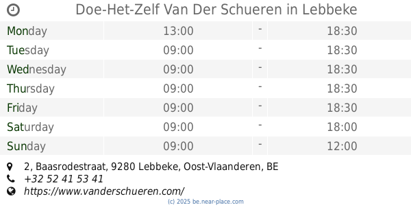
Doe-Het-Zelf Van Der Schueren
Baasrodestraat 2, Lebbeke
Store
read more
5.181 km
Grega
Maalderijstraat 38, Buggenhout
Store
read more
6.2 km
AVEVE DENDERMONDE - VERHODEMA BVBA
Heirbaan 269, Dendermonde
Store
read more
6.2 km
AVEVE Dendermonde
Heirbaan 269, Dendermonde
Store
read more
6.517 km
Laureys / Filip
Haagstraat 57, Dendermonde
Store
read more
6.593 km
't goede
Sint-Gillislaan Heirbaan 144, Dendermonde
Store
read more
📑
all categories
Accounting
Administrative area level 1
Administrative area level 2
Airport
Amusement park
Aquarium
Art gallery
Atm
Bakery
Bank
Bar
Beauty salon
Bicycle store
Book store
Bowling alley
Bus station
Cafe
Campground
Car dealer
Car rental
Car repair
Car wash
Casino
Cemetery
Church
City hall
Clothing store
Colloquial area
Convenience store
Country
Courthouse
Dentist
Department store
Doctor
Electrician
Electronics store
Embassy
Finance
Fire station
Florist
Food
Funeral home
Furniture store
Gas station
General contractor
Grocery or supermarket
Gym
Hair care
Hardware store
Health
Hindu Temple
Home goods store
Hospital
Insurance agency
Jewelry store
Laundry
Lawyer
Library
Light rail station
Liquor store
Local government office
Locality
Locksmith
Lodging
Meal delivery
Meal takeaway
Mosque
Movie rental
Movie theater
Moving company
Museum
Natural feature
Neighborhood
Night club
Painter
Park
Parking
Pet store
Pharmacy
Physiotherapist
Place of worship
Plumber
Point of interest
Police
Political
Post office
Premise
Real estate agency
Restaurant
Roofing contractor
Route
Rv park, camping
School
Shoe store
Shopping mall
Spa
Stadium
Storage
Store
Subpremise
Subway station
Supermarket
Synagogue
Taxi stand
Train station
Transit station
Travel agency
University
Veterinary care
Zoo
sublocality level 1
sublocality level 2
sublocality level 3
↑