Restaurant nearby Xarothi
Belgium
Restaurant nearby Xarothi
Xarothi
Bouwelsesteenweg 34, Nijlen België
contacts phone
:
+32
Latitude:
51.1638139
, Longitude:
4.6776922
read more
nearest Restaurant
65 m
Loos / Marcel
Bouwelsesteenweg 29, Nijlen
Restaurant
read more
237 m
Stefs Nijlen
Bouwelsesteenweg 4, Nijlen
Restaurant
read more
243 m
Sri Thai
Bouwelsesteenweg 4A, Nijlen
Restaurant
read more
265 m
Babatiti
Bouwelsesteenweg 91, Nijlen
Restaurant
read more
395 m
Bread Garden
Gemeentestraat 33-35, Nijlen
Restaurant
read more
409 m
Huang / Hui
Bouwelsesteenweg 115/A, Nijlen
Restaurant
read more
550 m
Frituur Tiosco
Kerkstraat 15, Nijlen
Restaurant
read more
583 m
Mr.Friet
Nonnenstraat 1, Nijlen
Restaurant
read more
585 m
Mr.Friet
nonnenstraa 1, Nijlen
Restaurant
read more
597 m
't Wit Huys
Kerkstraat 8, Nijlen
Restaurant
read more
633 m
Lek Thai Take Away
Kerkstraat 3, Nijlen
Restaurant
read more
635 m
Brasserie Criterium
Bevelsesteenweg 1, Nijlen
Restaurant
read more
639 m
China Garden Restaurant
Albertkanaalstraat 23, Nijlen
Restaurant
read more
711 m
Het Notariaat
Gebroeders van Raemdonckstraat 1, Nijlen
Restaurant
read more
834 m
Breakpoint
Statiestraat 3/B, Nijlen
Restaurant
read more
879 m
Taverne - Brasserie 't Wanneshof
Broechemsesteenweg 42, Nijlen
Restaurant
read more
1.045 km
Madame Tartelette
J. E. Claeslaan 48, Nijlen
Restaurant
read more
1.102 km
Slappen uier
Laurys Gewatstraat 79, Nijlen
Restaurant
read more
1.182 km
De gouden haan
Kesselsesteenweg 1, Nijlen
Restaurant
read more
1.22 km
Frituur 't Nief Plenke
Bouwelsesteenweg 257/A, Nijlen
Restaurant
read more
1.492 km
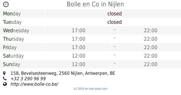
Bolle en Co
Bevelsesteenweg 158, Nijlen
Restaurant
read more
1.492 km
Brasserie De Grillhoeve
Bevelsesteenweg 158, Nijlen
Restaurant
read more
1.554 km
Wereldkeuken Diamant
Kesselsesteenweg 52, Nijlen
Restaurant
read more
3.38 km
Taverne Het Fort
Grote Puttingbaan 2a, Nijlen
Restaurant
read more
3.61 km
Hof van Eisterlee
Eikenlei 97, Grobbendonk
Restaurant
read more
📑
all categories
Accounting
Administrative area level 1
Administrative area level 2
Airport
Amusement park
Aquarium
Art gallery
Atm
Bakery
Bank
Bar
Beauty salon
Bicycle store
Book store
Bowling alley
Bus station
Cafe
Campground
Car dealer
Car rental
Car repair
Car wash
Casino
Cemetery
Church
City hall
Clothing store
Colloquial area
Convenience store
Country
Courthouse
Dentist
Department store
Doctor
Electrician
Electronics store
Embassy
Finance
Fire station
Florist
Food
Funeral home
Furniture store
Gas station
General contractor
Grocery or supermarket
Gym
Hair care
Hardware store
Health
Hindu Temple
Home goods store
Hospital
Insurance agency
Jewelry store
Laundry
Lawyer
Library
Light rail station
Liquor store
Local government office
Locality
Locksmith
Lodging
Meal delivery
Meal takeaway
Mosque
Movie rental
Movie theater
Moving company
Museum
Natural feature
Neighborhood
Night club
Painter
Park
Parking
Pet store
Pharmacy
Physiotherapist
Place of worship
Plumber
Point of interest
Police
Political
Post office
Premise
Real estate agency
Restaurant
Roofing contractor
Route
Rv park, camping
School
Shoe store
Shopping mall
Spa
Stadium
Storage
Store
Subpremise
Subway station
Supermarket
Synagogue
Taxi stand
Train station
Transit station
Travel agency
University
Veterinary care
Zoo
sublocality level 1
sublocality level 2
sublocality level 3
↑