Restaurant nearby ’t Frietsalon
Belgium
Restaurant nearby ’t Frietsalon
’t Frietsalon
Blankenbergse Steenweg 208, Brugge Belgia
contacts phone
:
+32
Latitude:
51.2303097
, Longitude:
3.2057069
read more
nearest Restaurant
910 m
Zuid55
Sint-Pieterszuidstraat 55, Brugge
Restaurant
read more
913 m
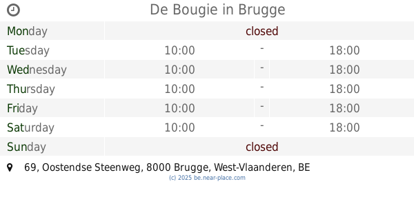
De Bougie
Oostendse Steenweg 69, Brugge
Restaurant
read more
914 m
Baristro Le Staff
Sint-Pieterszuidstraat 51, Brugge
Restaurant
read more
933 m
Kerim
Karel Mestdaghstraat, Brugge
Restaurant
read more
945 m
Dupon / Mornie
Blankenbergse Steenweg 65, Brugge
Restaurant
read more
991 m
Zandwegemolen
Oude Oostendse Steenweg 91-93, Brugge
Restaurant
read more
1.303 km
Ducheyne Atelier /traiteur ( lunch privé restaurant)
Scheepsdalelaan 69, Brugge
Restaurant
read more
1.328 km
Cantine Copine
Steenkaai 34S, Brugge
Restaurant
read more
1.334 km
De Kroon
Houtkaai 2, Brugge
Restaurant
read more
1.428 km
Hashtag Food
Scheepsdalelaan 37, Brugge
Restaurant
read more
1.47 km
Sing Wah
Scheepsdalelaan 46, Brugge
Restaurant
read more
1.674 km
Deskock
Kleine Monnikenwerve 26, Brugge
Restaurant
read more
1.686 km
Jua
Havenstraat 1, Brugge
Restaurant
read more
1.719 km
Oriental wok
Dudzeelse Steenweg 27, Brugge
Restaurant
read more
1.949 km
Croissanterie Ortiz
Ezelstraat 127, Brugge
Restaurant
read more
2.077 km
Achiel
Achiel van Ackerplein 2, Brugge
Restaurant
read more
2.085 km
Ribs 'n Beer
Ezelstraat 50, Brugge
Restaurant
read more
2.143 km
Bistro Du Phare
Sasplein 2, Brugge
Restaurant
read more
2.15 km
La Delizia
Sasplein 11, Brugge
Restaurant
read more
2.15 km
La Delizia mc bvba
Sasplein 11, Brugge
Restaurant
read more
2.157 km
Pizzeria Sforno
Sasplein 11, Brugge
Restaurant
read more
2.188 km
Clos Margaux - fine food & drinks
Sasplein 8, Brugge
Restaurant
read more
2.208 km
't Oud Handbogenhof
Baliestraat 6, Brugge
Restaurant
read more
2.543 km
Restaurant Cézar
Jeruzalemstraat 1, Brugge
Restaurant
read more
2.557 km
't Gezelleke
Carmersstraat 15, Brugge
Restaurant
read more
📑
all categories
Accounting
Administrative area level 1
Administrative area level 2
Airport
Amusement park
Aquarium
Art gallery
Atm
Bakery
Bank
Bar
Beauty salon
Bicycle store
Book store
Bowling alley
Bus station
Cafe
Campground
Car dealer
Car rental
Car repair
Car wash
Casino
Cemetery
Church
City hall
Clothing store
Colloquial area
Convenience store
Country
Courthouse
Dentist
Department store
Doctor
Electrician
Electronics store
Embassy
Finance
Fire station
Florist
Food
Funeral home
Furniture store
Gas station
General contractor
Grocery or supermarket
Gym
Hair care
Hardware store
Health
Hindu Temple
Home goods store
Hospital
Insurance agency
Jewelry store
Laundry
Lawyer
Library
Light rail station
Liquor store
Local government office
Locality
Locksmith
Lodging
Meal delivery
Meal takeaway
Mosque
Movie rental
Movie theater
Moving company
Museum
Natural feature
Neighborhood
Night club
Painter
Park
Parking
Pet store
Pharmacy
Physiotherapist
Place of worship
Plumber
Point of interest
Police
Political
Post office
Premise
Real estate agency
Restaurant
Roofing contractor
Route
Rv park, camping
School
Shoe store
Shopping mall
Spa
Stadium
Storage
Store
Subpremise
Subway station
Supermarket
Synagogue
Taxi stand
Train station
Transit station
Travel agency
University
Veterinary care
Zoo
sublocality level 1
sublocality level 2
sublocality level 3
↑