Restaurant nearby SMACK
Belgium
Restaurant nearby SMACK
SMACK
Place Albert-Elisabeth 46, Saint-Ghislain Belgique
contacts phone
:
+32
Latitude:
50.440666
, Longitude:
3.818033
read more
nearest Restaurant
312 m
Chicken Hunterz
Place Albert-Elisabeth 36, Saint-Ghislain
Restaurant
read more
361 m
L'étoile - Brasserie
Place Albert-Elisabeth 18, Saint-Ghislain
Restaurant
read more
417 m
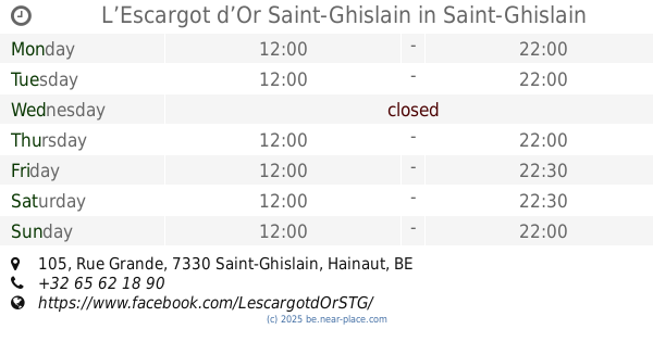
L’Escargot d’Or Saint-Ghislain
Rue Grande 105, Saint-Ghislain
Restaurant
read more
479 m
Pizzeria Del Sole
Rue de la Fontaine 163, Boussu
Restaurant
read more
507 m
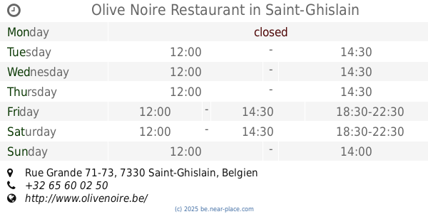
Olive Noire Restaurant
Rue Grande 71-73, Saint-Ghislain
Restaurant
read more
510 m
Diner 66
Rue de la Fontaine 66, Boussu
Restaurant
read more
523 m
Coupé Couteau
Rue Grande 70, Saint-Ghislain
Restaurant
read more
526 m
Tandem
Rue Grande 57, Saint-Ghislain
Restaurant
read more
554 m
Chan Quig
Rue de la Fontaine 76, Boussu
Restaurant
read more
570 m
Minute Papillon
Rue Grande 53, Saint-Ghislain
Restaurant
read more
604 m
Pitta Antalya
Rue Grande 48, Saint-Ghislain
Restaurant
read more
782 m
Epoca del sole
Rue de Valenciennes 303, Boussu
Restaurant
read more
840 m
Concordia
Grand'Place 46, Saint-Ghislain
Restaurant
read more
846 m
Bonifacio
Rue d'Ath 17, Saint-Ghislain
Restaurant
read more
870 m
Pizzeria de l'Abbaye
Grand'Place 32, Saint-Ghislain
Restaurant
read more
882 m
La Table Du Mandarin
Grand'Place 40, Saint-Ghislain
Restaurant
read more
882 m
Le Méridien
Rue Grande 51, Boussu
Restaurant
read more
886 m
La Patat'in
Rue Grande 58, Boussu
Restaurant
read more
929 m
Deli Presto
Cité Spruyt 3/1C, Bte 8, Saint-Ghislain
Restaurant
read more
929 m
Carestel
Autoroute E 19/-E42 1, Saint-Ghislain
Restaurant
read more
936 m
La Tartine Hornu
Rue Grande 74, Boussu
Restaurant
read more
950 m
Orangerie (L')
Rue de Mons 102, Boussu
Restaurant
read more
1.029 km
Rong Xing
Rue de Mons 95, Boussu
Restaurant
read more
1.116 km
chez Rudy et Fanny
Rue Grande 110, Boussu
Restaurant
read more
1.321 km
Lupica / Signorino
Rue de Valenciennes 487, Boussu
Restaurant
read more
📑
all categories
Accounting
Administrative area level 1
Administrative area level 2
Airport
Amusement park
Aquarium
Art gallery
Atm
Bakery
Bank
Bar
Beauty salon
Bicycle store
Book store
Bowling alley
Bus station
Cafe
Campground
Car dealer
Car rental
Car repair
Car wash
Casino
Cemetery
Church
City hall
Clothing store
Colloquial area
Convenience store
Country
Courthouse
Dentist
Department store
Doctor
Electrician
Electronics store
Embassy
Finance
Fire station
Florist
Food
Funeral home
Furniture store
Gas station
General contractor
Grocery or supermarket
Gym
Hair care
Hardware store
Health
Hindu Temple
Home goods store
Hospital
Insurance agency
Jewelry store
Laundry
Lawyer
Library
Light rail station
Liquor store
Local government office
Locality
Locksmith
Lodging
Meal delivery
Meal takeaway
Mosque
Movie rental
Movie theater
Moving company
Museum
Natural feature
Neighborhood
Night club
Painter
Park
Parking
Pet store
Pharmacy
Physiotherapist
Place of worship
Plumber
Point of interest
Police
Political
Post office
Premise
Real estate agency
Restaurant
Roofing contractor
Route
Rv park, camping
School
Shoe store
Shopping mall
Spa
Stadium
Storage
Store
Subpremise
Subway station
Supermarket
Synagogue
Taxi stand
Train station
Transit station
Travel agency
University
Veterinary care
Zoo
sublocality level 1
sublocality level 2
sublocality level 3
↑