Restaurant nearby Kombuis
Belgium
Restaurant nearby Kombuis
Kombuis
Van Iseghemlaan 24, Oostende Belgique
contacts phone
:
+32
Latitude:
51.2340108
, Longitude:
2.9168875
read more
nearest Restaurant
188 m
Le BORD'EAU
Albert I-promenade 46-47, Oostende
Restaurant
read more
190 m
Visrestaurant Arno's Café
Wapenplein 8, Oostende
Restaurant
read more
193 m
Pizzeria Tropic
Christinastraat 18F, Oostende
Restaurant
read more
238 m
De Mangerie
Albert I-promenade 10, Oostende
Restaurant
read more
244 m
Eetkaffee Poseidon
Hertstraat 11, Oostende
Restaurant
read more
273 m
Brûtal
Mijnplein 13/14, Oostende
Restaurant
read more
283 m
DAMAS resturant
Hertstraat 10, Oostende
Restaurant
read more
287 m
Kreta
Hertstraat 7, Oostende
Restaurant
read more
319 m
Wijnbistro diVino
Wittenonnenstraat 2, Oostende
Restaurant
read more
323 m
't Blaffetuurken
Visserskaai 39, Oostende
Restaurant
read more
326 m
Restaurant De Amandine
Visserskaai 38, Oostende
Restaurant
read more
331 m
Vistrapje ('t) bvba
Visserskaai 37, Oostende
Restaurant
read more
349 m
New Lusitania
Visserskaai 35, Oostende
Restaurant
read more
517 m
Bistro chopin
Visserskaai 13, Oostende
Restaurant
read more
539 m
't Mespuntje
Sint-Paulusstraat 82, Oostende
Restaurant
read more
562 m
Restaurant St-Malo / Zonnekein Ronny
Albert I-promenade 62/A, Oostende
Restaurant
read more
612 m
Brasserie Paulus
Sint-Petrus-en-Paulusplein 10, Oostende
Restaurant
read more
683 m
LIDO SOLE - Italiaans Restaurant
Albert I-promenade 67, Oostende
Restaurant
read more
693 m
Freddy's Must (Restaurant)
Albert I-promenade 67/B, Oostende
Restaurant
read more
698 m
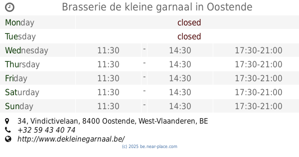
Brasserie de kleine garnaal
Vindictivelaan 34, Oostende
Restaurant
read more
856 m
Panos
Oostende Station, Natiënkaai 1, Oostende
Restaurant
read more
908 m
De Combi
44, Alfons Pieterslaan, Oostende
Restaurant
read more
922 m
Panos
Ernest Feysplein 16, Oostende
Restaurant
read more
936 m
RESTAURANT -TEAROOM LENTINI
Alfons Pieterslaan 41, Oostende
Restaurant
read more
1.091 km
Funky Friet House
Torhoutsesteenweg 47, Oostende
Restaurant
read more
📑
all categories
Accounting
Administrative area level 1
Administrative area level 2
Airport
Amusement park
Aquarium
Art gallery
Atm
Bakery
Bank
Bar
Beauty salon
Bicycle store
Book store
Bowling alley
Bus station
Cafe
Campground
Car dealer
Car rental
Car repair
Car wash
Casino
Cemetery
Church
City hall
Clothing store
Colloquial area
Convenience store
Country
Courthouse
Dentist
Department store
Doctor
Electrician
Electronics store
Embassy
Finance
Fire station
Florist
Food
Funeral home
Furniture store
Gas station
General contractor
Grocery or supermarket
Gym
Hair care
Hardware store
Health
Hindu Temple
Home goods store
Hospital
Insurance agency
Jewelry store
Laundry
Lawyer
Library
Light rail station
Liquor store
Local government office
Locality
Locksmith
Lodging
Meal delivery
Meal takeaway
Mosque
Movie rental
Movie theater
Moving company
Museum
Natural feature
Neighborhood
Night club
Painter
Park
Parking
Pet store
Pharmacy
Physiotherapist
Place of worship
Plumber
Point of interest
Police
Political
Post office
Premise
Real estate agency
Restaurant
Roofing contractor
Route
Rv park, camping
School
Shoe store
Shopping mall
Spa
Stadium
Storage
Store
Subpremise
Subway station
Supermarket
Synagogue
Taxi stand
Train station
Transit station
Travel agency
University
Veterinary care
Zoo
sublocality level 1
sublocality level 2
sublocality level 3
↑