Restaurant nearby Kebabylon
Belgium
Restaurant nearby Kebabylon
Kebabylon
Markt 21, Tielt Belgique
contacts phone
:
+32
Latitude:
51.0003292
, Longitude:
3.3278167
read more
nearest Restaurant
75 m
Piadza
Markt 34, Tielt
Restaurant
read more
104 m
Markt 4 Bvba
Markt 4, Tielt
Restaurant
read more
105 m
Charlies
Markt 3, Tielt
Restaurant
read more
130 m
Restaurant QV
Kortrijkstraat 3, Tielt
Restaurant
read more
161 m
Panos
Kortrijkstraat 27, Tielt
Restaurant
read more
174 m
Pizza Aversa
Ieperstraat 10, Tielt
Restaurant
read more
219 m
snack tielt
Kortrijkstraat 43, Tielt
Restaurant
read more
236 m
Baert / Sofie
Hulststraat 2, Tielt
Restaurant
read more
241 m
La vita e bella
62, N399b 58, Tielt
Restaurant
read more
249 m
La Vita è Bella Tielt / Taormina
8700, Kortrijkstraat 52, Tielt
Restaurant
read more
262 m
De Traagheid
Krommewalstraat 6, Tielt
Restaurant
read more
374 m
Carlito
Kortrijkstraat 80, Tielt
Restaurant
read more
408 m
Palette cuisine
Ieperstraat 57, Tielt
Restaurant
read more
423 m
Crommenwal
Krommewalstraat 38, Tielt
Restaurant
read more
499 m
Mitro Snacks & Broodjes
Felix D'Hoopstraat 42, Tielt
Restaurant
read more
527 m
Het Stil Vermoeden
Sint-Michielstraat 32, Tielt
Restaurant
read more
660 m
Pita Frituur Antalya
Kortrijkstraat 150-154, Tielt
Restaurant
read more
742 m
Foodbar Yummy
Stationstraat 14, Tielt
Restaurant
read more
1.827 km
Het Tomme Goed
Rijkegemkouterstraat 7, Tielt
Restaurant
read more
2.996 km
parochiaal centrum
Oostrozebeke
Restaurant
read more
3.756 km
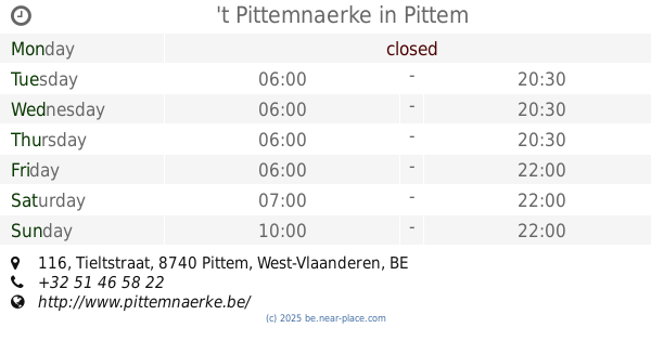
't Pittemnaerke
Tieltstraat 116, Pittem
Restaurant
read more
6.085 km
De Nieuwe Lekkerbek
Tieltstraat 29, Ruiselede
Restaurant
read more
6.523 km
Charbon
Kasteelstraat 9, Ruiselede
Restaurant
read more
6.621 km
Pitta Kervan
Bruggestraat 13, Ruiselede
Restaurant
read more
10.024 km
Salons Gistelhove/ De ghistel / brochterrie de pauw
Wielewaalstraat 18, Izegem
Restaurant
read more
📑
all categories
Accounting
Administrative area level 1
Administrative area level 2
Airport
Amusement park
Aquarium
Art gallery
Atm
Bakery
Bank
Bar
Beauty salon
Bicycle store
Book store
Bowling alley
Bus station
Cafe
Campground
Car dealer
Car rental
Car repair
Car wash
Casino
Cemetery
Church
City hall
Clothing store
Colloquial area
Convenience store
Country
Courthouse
Dentist
Department store
Doctor
Electrician
Electronics store
Embassy
Finance
Fire station
Florist
Food
Funeral home
Furniture store
Gas station
General contractor
Grocery or supermarket
Gym
Hair care
Hardware store
Health
Hindu Temple
Home goods store
Hospital
Insurance agency
Jewelry store
Laundry
Lawyer
Library
Light rail station
Liquor store
Local government office
Locality
Locksmith
Lodging
Meal delivery
Meal takeaway
Mosque
Movie rental
Movie theater
Moving company
Museum
Natural feature
Neighborhood
Night club
Painter
Park
Parking
Pet store
Pharmacy
Physiotherapist
Place of worship
Plumber
Point of interest
Police
Political
Post office
Premise
Real estate agency
Restaurant
Roofing contractor
Route
Rv park, camping
School
Shoe store
Shopping mall
Spa
Stadium
Storage
Store
Subpremise
Subway station
Supermarket
Synagogue
Taxi stand
Train station
Transit station
Travel agency
University
Veterinary care
Zoo
sublocality level 1
sublocality level 2
sublocality level 3
↑