Restaurant nearby De Molen
Belgium
Restaurant nearby De Molen
De Molen
Stenedorpstraat 4, Oostende Belgium
contacts phone
:
+32
Latitude:
51.202267
, Longitude:
2.9147162
read more
nearest Restaurant
30 m
De Vlasschaard
Oudstrijdersplein 5, Oostende
Restaurant
read more
43 m
Genoegen ('t) (Restaurant)
Stenedorpstraat 23, Oostende
Restaurant
read more
49 m
Bistro De Lisse
Stenedorpstraat 27, Oostende
Restaurant
read more
53 m
't Pomptje
Oudstrijdersplein 2, Oostende
Restaurant
read more
54 m
Devos / Reinaart
Stenedorpstraat 29, Oostende
Restaurant
read more
72 m
Estaminet
Steensedijk 60, Oostende
Restaurant
read more
79 m
Nieuw Stene
Zilverlaan 5, Oostende
Restaurant
read more
112 m
Sassy's
Steensedijk 23, Oostende
Restaurant
read more
691 m
Blonde / Alain
Rosmolenstraat 2, Oostende
Restaurant
read more
694 m
De Rosmolen
Rosmolenstraat 8400, Oostende
Restaurant
read more
816 m
Van Gogh bvba
Torhoutsesteenweg 601, Oostende
Restaurant
read more
819 m
McDonald's Oostende Drive
Torhoutsesteenweg 582, Oostende
Restaurant
read more
933 m
't Vliegplein
Steensedijk 253, Oostende
Restaurant
read more
1.155 km
Pita Huis Breugheltje
Mariakerkelaan 68, Oostende
Restaurant
read more
1.68 km
Yiying
Torhoutsesteenweg 293, Oostende
Restaurant
read more
1.68 km
China Keuken
Torhoutsesteenweg 293, Oostende
Restaurant
read more
1.778 km
Bella / S.
Leffingestraat 164, Oostende
Restaurant
read more
1.781 km
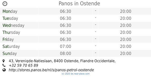
Panos
Q8, Verenigde-Natieslaan 43, Oostende
Restaurant
read more
1.786 km
't Smosje
Torhoutsesteenweg 259, Oostende
Restaurant
read more
2.232 km
Pizza Express
Ijzerwegstraat 1, Oostende
Restaurant
read more
2.282 km
Knapp
Zandvoordestraat 75, Oostende
Restaurant
read more
2.344 km
Frituur Rudy
Nieuwpoortsesteenweg 515, Oostende
Restaurant
read more
2.646 km
El Rey
Troonstraat 32, Oostende
Restaurant
read more
2.699 km
Pizzeria Last Minute
Troonstraat 81, Oostende
Restaurant
read more
2.751 km
North
Zeedijk 137/C, Oostende
Restaurant
read more
📑
all categories
Accounting
Administrative area level 1
Administrative area level 2
Airport
Amusement park
Aquarium
Art gallery
Atm
Bakery
Bank
Bar
Beauty salon
Bicycle store
Book store
Bowling alley
Bus station
Cafe
Campground
Car dealer
Car rental
Car repair
Car wash
Casino
Cemetery
Church
City hall
Clothing store
Colloquial area
Convenience store
Country
Courthouse
Dentist
Department store
Doctor
Electrician
Electronics store
Embassy
Finance
Fire station
Florist
Food
Funeral home
Furniture store
Gas station
General contractor
Grocery or supermarket
Gym
Hair care
Hardware store
Health
Hindu Temple
Home goods store
Hospital
Insurance agency
Jewelry store
Laundry
Lawyer
Library
Light rail station
Liquor store
Local government office
Locality
Locksmith
Lodging
Meal delivery
Meal takeaway
Mosque
Movie rental
Movie theater
Moving company
Museum
Natural feature
Neighborhood
Night club
Painter
Park
Parking
Pet store
Pharmacy
Physiotherapist
Place of worship
Plumber
Point of interest
Police
Political
Post office
Premise
Real estate agency
Restaurant
Roofing contractor
Route
Rv park, camping
School
Shoe store
Shopping mall
Spa
Stadium
Storage
Store
Subpremise
Subway station
Supermarket
Synagogue
Taxi stand
Train station
Transit station
Travel agency
University
Veterinary care
Zoo
sublocality level 1
sublocality level 2
sublocality level 3
↑