Restaurant nearby Belegde Broodjes 144
Coronavirus disease (COVID-19) Situation
confirmed cases
4861695
deaths
34376
Belgium
Restaurant nearby Belegde Broodjes 144
Belegde Broodjes 144
Prinsessestraat 144, Izegem Belgium
contacts phone
:
+32
Latitude:
50.923165
, Longitude:
3.2215
read more
nearest Restaurant
218 m
lucrare izeghen
Zuidkaai 6-4, Izegem
Restaurant
read more
386 m
Winkels
Kouterweg 15, Izegem
Restaurant
read more
539 m
Thais restaurant KAI FA
30, Vijfwegenstraat, Izegem
Restaurant
read more
580 m
Santa Maria
Grote Markt 2, Izegem
Restaurant
read more
583 m
Vintage
Grote Markt 28, Izegem
Restaurant
read more
597 m
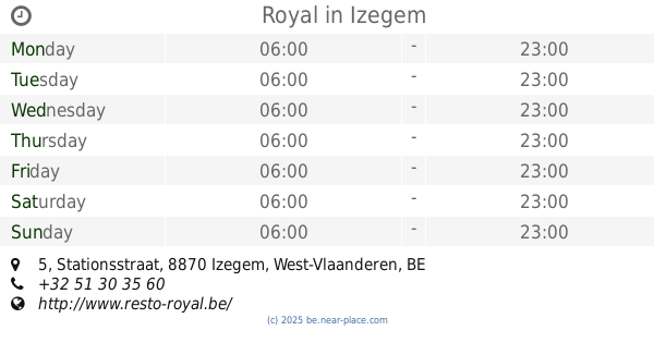
Royal
Stationsstraat 5, Izegem
Restaurant
read more
617 m
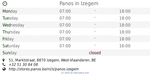
Panos
Marktstraat 51, Izegem
Restaurant
read more
642 m
Parrein / Peter Erik
Korenmarkt 23, Izegem
Restaurant
read more
653 m
And'Iz
Korenmarkt 15, Izegem
Restaurant
read more
672 m
Le Petit Jardin
Marktstraat 24, Izegem
Restaurant
read more
696 m
De Pril / Tania
Melkmarkt 5, Izegem
Restaurant
read more
710 m
Faggio Rosso
Melkmarkt 4, Izegem
Restaurant
read more
735 m
De Smaak
Gentsestraat 27, Izegem
Restaurant
read more
758 m
Bistro Belle Restaurant Lounge
Gentsestraat 18, Izegem
Restaurant
read more
881 m
St-Christophe
Sint-Pietersstraat 4, Izegem
Restaurant
read more
885 m
't Emelryck
Nachtegaalstraat 6, Izegem
Restaurant
read more
900 m
Bierkasteel
Brouwerijstraat 1, Emelgem
Restaurant
read more
900 m
Bierkasteel Brasserie
Brouwerijstraat 1, Emelgem
Restaurant
read more
902 m
'T Kaderke
Sint-Pietersstraat 1, Izegem
Restaurant
read more
926 m
Brasserie Marbre
Roeselaarsestraat 57, Izegem
Restaurant
read more
930 m
't Hemelhuys
Sint-Pietersstraat 16, Izegem
Restaurant
read more
936 m
De Oude Sint Pieter
Sint-Pietersstraat 18, Izegem
Restaurant
read more
949 m
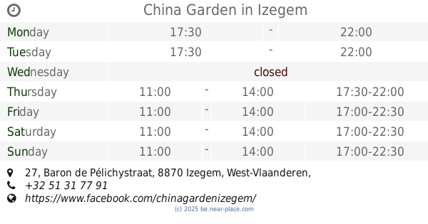
China Garden
Baron de Pélichystraat 27, Izegem
Restaurant
read more
954 m
Pita Dilan
Ommegangstraat 2, Izegem
Restaurant
read more
1.029 km
Ristorante Pizzeria La Vita è bella
Krekelstraat 52, Izegem
Restaurant
read more
📑
all categories
Accounting
Administrative area level 1
Administrative area level 2
Airport
Amusement park
Aquarium
Art gallery
Atm
Bakery
Bank
Bar
Beauty salon
Bicycle store
Book store
Bowling alley
Bus station
Cafe
Campground
Car dealer
Car rental
Car repair
Car wash
Casino
Cemetery
Church
City hall
Clothing store
Colloquial area
Convenience store
Country
Courthouse
Dentist
Department store
Doctor
Electrician
Electronics store
Embassy
Finance
Fire station
Florist
Food
Funeral home
Furniture store
Gas station
General contractor
Grocery or supermarket
Gym
Hair care
Hardware store
Health
Hindu Temple
Home goods store
Hospital
Insurance agency
Jewelry store
Laundry
Lawyer
Library
Light rail station
Liquor store
Local government office
Locality
Locksmith
Lodging
Meal delivery
Meal takeaway
Mosque
Movie rental
Movie theater
Moving company
Museum
Natural feature
Neighborhood
Night club
Painter
Park
Parking
Pet store
Pharmacy
Physiotherapist
Place of worship
Plumber
Point of interest
Police
Political
Post office
Premise
Real estate agency
Restaurant
Roofing contractor
Route
Rv park, camping
School
Shoe store
Shopping mall
Spa
Stadium
Storage
Store
Subpremise
Subway station
Supermarket
Synagogue
Taxi stand
Train station
Transit station
Travel agency
University
Veterinary care
Zoo
sublocality level 1
sublocality level 2
sublocality level 3
↑