Restaurant nearby Au Petit Chef
Belgium
Restaurant nearby Au Petit Chef
Au Petit Chef
5-6, Place de Rome, 4960, Malmedy, Liège, BE Belgien
contacts phone
:
+32 80 33 07 49
website:
aupetitchef.be
Latitude:
50.4257765
, Longitude:
6.0253672
larger map & directions
read more
nearest Restaurant
30 m
La Gourmandine
Place de Rome 3, Malmedy
Restaurant
read more
30 m
Hanf / Michel
Place de Rome 3, Malmedy
Restaurant
read more
112 m
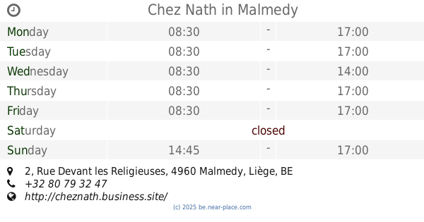
Chez Nath
Rue Devant les Religieuses 2, Malmedy
Restaurant
read more
163 m
Hammami / Abderrazak
Place Albert1er 14, Malmedy
Restaurant
read more
182 m
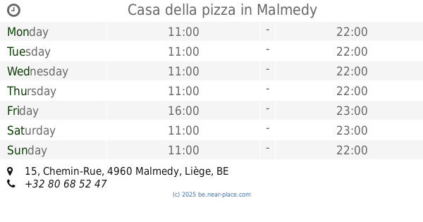
Casa della pizza
Chemin-Rue 15, Malmedy
Restaurant
read more
197 m
Traiteur
Rue Devant l'Etang 1, Malmedy
Restaurant
read more
207 m
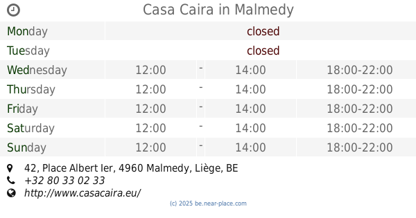
Casa Caira
Place Albert Ier 42, Malmedy
Restaurant
read more
219 m
La Charbonnade
Rue Devant l'Etang 11, Malmedy
Restaurant
read more
228 m
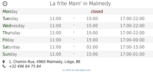
La frite Mam'
Chemin-Rue 1, Malmedy
Restaurant
read more
250 m
Le Floréal
Place Albert Ier 8, Malmedy
Restaurant
read more
294 m
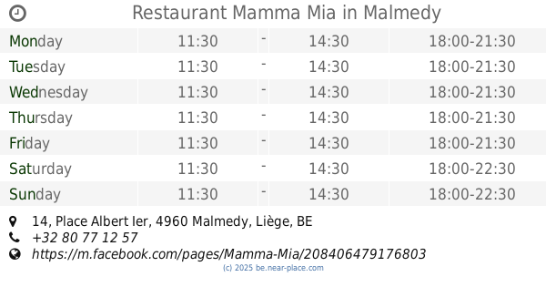
Restaurant Mamma Mia
Place Albert Ier 14, Malmedy
Restaurant
read more
294 m
Mamma Mia
Place Albert Ier 14, Malmedy
Restaurant
read more
294 m
Restaurant Mama Mia
Place Albert Ier 14, Malmedy
Restaurant
read more
295 m
La Dona Trattoria
Avenue des Alliés 5-21, Malmedy
Restaurant
read more
309 m
Moa restaurant
Place Albert Ier 16, Malmedy
Restaurant
read more
313 m
Pita Calimero
Rue du Commerce, Malmedy
Restaurant
read more
315 m
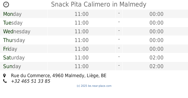
Snack Pita Calimero
Rue du Commerce, Malmedy
Restaurant
read more
338 m
Asia Délices
Rue du Commerce 6, Malmedy
Restaurant
read more
354 m
Chez Maddy
Rue du Commerce 8, Malmedy
Restaurant
read more
373 m
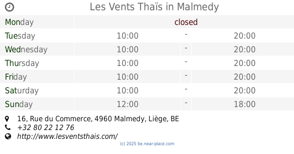
Les Vents Thaïs
Rue du Commerce 16, Malmedy
Restaurant
read more
392 m
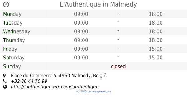
L'Authentique
Place du Commerce 5, Malmedy
Restaurant
read more
395 m
Soirée à Carthage
Rue du Commerce 24, Malmedy
Restaurant
read more
908 m
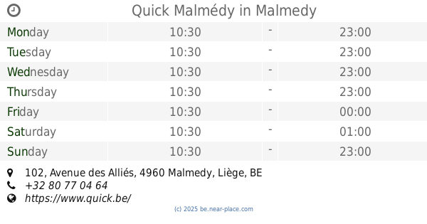
Quick Malmédy
Avenue des Alliés 102, Malmedy
Restaurant
read more
908 m
Quick
Avenue des Alliés 102, Malmedy
Restaurant
read more
1.047 km
Le Wok
Avenue Monbijou 53, Malmedy
Restaurant
read more
📑
all categories
Accounting
Administrative area level 1
Administrative area level 2
Airport
Amusement park
Aquarium
Art gallery
Atm
Bakery
Bank
Bar
Beauty salon
Bicycle store
Book store
Bowling alley
Bus station
Cafe
Campground
Car dealer
Car rental
Car repair
Car wash
Casino
Cemetery
Church
City hall
Clothing store
Colloquial area
Convenience store
Country
Courthouse
Dentist
Department store
Doctor
Electrician
Electronics store
Embassy
Finance
Fire station
Florist
Food
Funeral home
Furniture store
Gas station
General contractor
Grocery or supermarket
Gym
Hair care
Hardware store
Health
Hindu Temple
Home goods store
Hospital
Insurance agency
Jewelry store
Laundry
Lawyer
Library
Light rail station
Liquor store
Local government office
Locality
Locksmith
Lodging
Meal delivery
Meal takeaway
Mosque
Movie rental
Movie theater
Moving company
Museum
Natural feature
Neighborhood
Night club
Painter
Park
Parking
Pet store
Pharmacy
Physiotherapist
Place of worship
Plumber
Point of interest
Police
Political
Post office
Premise
Real estate agency
Restaurant
Roofing contractor
Route
Rv park, camping
School
Shoe store
Shopping mall
Spa
Stadium
Storage
Store
Subpremise
Subway station
Supermarket
Synagogue
Taxi stand
Train station
Transit station
Travel agency
University
Veterinary care
Zoo
sublocality level 1
sublocality level 2
sublocality level 3
↑