Post office nearby Postkantoor
Belgium
Post office nearby Postkantoor
Postkantoor
8650, Houthulst, Belgia
contacts phone
:
+32
Latitude:
50.9764998
, Longitude:
2.9519739
larger map & directions
read more
nearest Post office
32 m
bpost
MARKT 25, Houthulst
Post office
read more
4.611 km
bpost
Sint Jansstraat 54, Staden
Post office
read more
4.642 km
Postpunt Proxy Delhaize Zarren
Kortemark
Post office
read more
5.466 km
bpost - Staden
Sint Jansstraat 54, Staden
Post office
read more
7.284 km
bpost
Vijverstraat 9, Langemark-Poelkapelle
Post office
read more
8.505 km
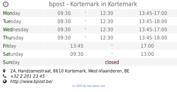
bpost
Handzamestraat 2A, Kortemark
Post office
read more
8.525 km
bpost - Kortemark
Handzamestraat 2A, Kortemark
Post office
read more
8.944 km
bpost
Grauwe Broedersstraat 1, Diksmuide
Post office
read more
9.091 km
bpost
Marktplaats 31, Hooglede
Post office
read more
11.953 km
bpost - Zonnebeke
Zonnebeke
Post office
read more
11.955 km
bpost
Ieperstraat 39, Zonnebeke
Post office
read more
11.981 km
bpost - Zonnebeke
Ieperstraat 39, Zonnebeke
Post office
read more
11.997 km
Postpunt Delhaize Roeselare
Westkouter, Roeselare
Post office
read more
12.17 km
bpost Roeselare
Wijnendalestraat 181, Roeselare
Post office
read more
12.292 km
bpost
Pater Lievensstraat 2A, Moorslede
Post office
read more
12.573 km
bpost - Roeselare
Meensesteenweg 51, Roeselare
Post office
read more
12.883 km
bpost - Koekelare
Koekelare
Post office
read more
13.226 km
Postpunt Spar Lemahieu
Ieper
Post office
read more
13.771 km
bpost
Statiestraat 88, Lichtervelde
Post office
read more
14.228 km
bpost
LICHTERVELDESTR 38, Torhout
Post office
read more
14.92 km
Postpunt Dagbladhandel Taptoe Rumbeke
Rumbeeksesteenweg 484, Roeselare
Post office
read more
14.973 km
bpost
STUDENTENSTR 10, Ieper
Post office
read more
16.478 km
Postpunt Spar Retail Vlamertinge
Ieper
Post office
read more
16.478 km
Postpunt Spar Retail Vlamertinge
Ypres
Post office
read more
18.014 km
bpost
Stationsstraat 94, Ledegem
Post office
read more
📑
all categories
Accounting
Administrative area level 1
Administrative area level 2
Airport
Amusement park
Aquarium
Art gallery
Atm
Bakery
Bank
Bar
Beauty salon
Bicycle store
Book store
Bowling alley
Bus station
Cafe
Campground
Car dealer
Car rental
Car repair
Car wash
Casino
Cemetery
Church
City hall
Clothing store
Colloquial area
Convenience store
Country
Courthouse
Dentist
Department store
Doctor
Electrician
Electronics store
Embassy
Finance
Fire station
Florist
Food
Funeral home
Furniture store
Gas station
General contractor
Grocery or supermarket
Gym
Hair care
Hardware store
Health
Hindu Temple
Home goods store
Hospital
Insurance agency
Jewelry store
Laundry
Lawyer
Library
Light rail station
Liquor store
Local government office
Locality
Locksmith
Lodging
Meal delivery
Meal takeaway
Mosque
Movie rental
Movie theater
Moving company
Museum
Natural feature
Neighborhood
Night club
Painter
Park
Parking
Pet store
Pharmacy
Physiotherapist
Place of worship
Plumber
Point of interest
Police
Political
Post office
Premise
Real estate agency
Restaurant
Roofing contractor
Route
Rv park, camping
School
Shoe store
Shopping mall
Spa
Stadium
Storage
Store
Subpremise
Subway station
Supermarket
Synagogue
Taxi stand
Train station
Transit station
Travel agency
University
Veterinary care
Zoo
sublocality level 1
sublocality level 2
sublocality level 3
↑