Pharmacy nearby Multipharma
Belgium
Pharmacy nearby Multipharma
Multipharma
Wayezstraat 111, Anderlecht Belgium
contacts phone
:
+32
Latitude:
50.8356862
, Longitude:
4.3111732
read more
nearest Pharmacy
275 m
Multipharma Pharmacie
Dapperheidsplein 1, Anderlecht
Pharmacy
read more
297 m
Holvoet Hendrik & Kathleen
Wayezstraat 48, Anderlecht
Pharmacy
read more
298 m
Apotheek D'aumale
Anderlecht
Pharmacy
read more
347 m
Bennani. A
Doverstraat 117, Anderlecht
Pharmacy
read more
347 m
Bennani. A
Rue de Douvres 117, Anderlecht
Pharmacy
read more
349 m
Apotheek Bennani
Anderlecht
Pharmacy
read more
349 m
Pharmacie Bennani
Anderlecht
Pharmacy
read more
401 m
Apotheek
Rue Archimède 11, Bruxelles
Pharmacy
read more
401 m
Apotheek
Archimedesstraat 11, Brussel
Pharmacy
read more
411 m
Pharmacie Dumoulin
Anderlecht
Pharmacy
read more
449 m
Pharmacie Truyts
Anderlecht
Pharmacy
read more
455 m
Daluphar
Rue Edmond Delcourt 53, Anderlecht
Pharmacy
read more
482 m
Multipharma Pharmacie Anderlecht
Bergensesteenweg 606, Anderlecht
Pharmacy
read more
658 m
Pharmacie du Parc Astrid
Dokter Jacobsstraat 88, Anderlecht
Pharmacy
read more
777 m
Apotheek LloydsPharma Brusse A. Willemijns
Adolphe Willemynsstraat 3, Brussel
Pharmacy
read more
826 m
Villo! station de linde
Place De Linde 22, Anderlecht
Pharmacy
read more
902 m
Agalec sa
Aristide Briandlaan 5, Anderlecht
Pharmacy
read more
912 m
Apotheek Agalec
Anderlecht
Pharmacy
read more
949 m
Pharmanderlecht
Henri Reysquare 3, Anderlecht
Pharmacy
read more
957 m
Pharmasquare
Koloniale-Veteranensquare 6, Anderlecht
Pharmacy
read more
957 m
Pharmasquare
Square des Vétérans Coloniaux 6, Anderlecht
Pharmacy
read more
1.046 km
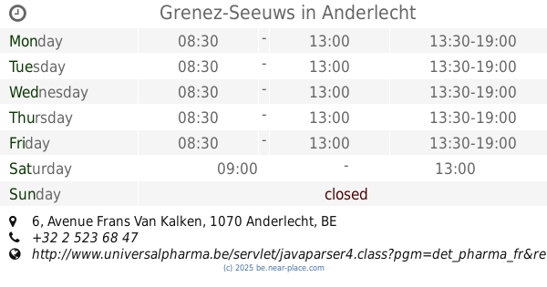
Grenez-Seeuws
Avenue Frans Van Kalken 6, Anderlecht
Pharmacy
read more
1.046 km
Apotheek Grenez-Seews
Anderlecht
Pharmacy
read more
1.046 km
Pharmacie Grenez-Seews
Anderlecht
Pharmacy
read more
1.232 km
Pharmacie Weerebrouck
Anderlecht
Pharmacy
read more
📑
all categories
Accounting
Administrative area level 1
Administrative area level 2
Airport
Amusement park
Aquarium
Art gallery
Atm
Bakery
Bank
Bar
Beauty salon
Bicycle store
Book store
Bowling alley
Bus station
Cafe
Campground
Car dealer
Car rental
Car repair
Car wash
Casino
Cemetery
Church
City hall
Clothing store
Colloquial area
Convenience store
Country
Courthouse
Dentist
Department store
Doctor
Electrician
Electronics store
Embassy
Finance
Fire station
Florist
Food
Funeral home
Furniture store
Gas station
General contractor
Grocery or supermarket
Gym
Hair care
Hardware store
Health
Hindu Temple
Home goods store
Hospital
Insurance agency
Jewelry store
Laundry
Lawyer
Library
Light rail station
Liquor store
Local government office
Locality
Locksmith
Lodging
Meal delivery
Meal takeaway
Mosque
Movie rental
Movie theater
Moving company
Museum
Natural feature
Neighborhood
Night club
Painter
Park
Parking
Pet store
Pharmacy
Physiotherapist
Place of worship
Plumber
Point of interest
Police
Political
Post office
Premise
Real estate agency
Restaurant
Roofing contractor
Route
Rv park, camping
School
Shoe store
Shopping mall
Spa
Stadium
Storage
Store
Subpremise
Subway station
Supermarket
Synagogue
Taxi stand
Train station
Transit station
Travel agency
University
Veterinary care
Zoo
sublocality level 1
sublocality level 2
sublocality level 3
↑