Park nearby Plaine de Jeux Josaphat
Belgium
Park nearby Plaine de Jeux Josaphat
Plaine de Jeux Josaphat
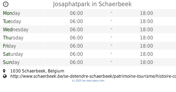
1030 Schaerbeek, Belgium
contacts phone
:
+32
Latitude:
50.8608324
, Longitude:
4.3895408
larger map & directions
read more
nearest Park
261 m
Latinis Garden
Avenue Gustave Latinis 152, Schaerbeek
Park
read more
369 m
Muziekkiosk Josafatpark
Schaerbeek
Park
read more
490 m
Weldoenersplein
Schaerbeek
Park
read more
523 m
Josaphatpark
Schaerbeek
Park
read more
635 m
Plaine de Jeux Lacroix
Schaerbeek
Park
read more
670 m
Albertpark
Schaerbeek
Park
read more
1.088 km
Écologique Garden
Unnamed Road, Evere
Park
read more
1.152 km
Plaine de Jeux Rasquinet
Schaerbeek
Park
read more
1.157 km
Armand Steurs Square
Saint-Josse-ten-Noode
Park
read more
1.161 km
Parc Dunant / Park Dunant
Avenue Henry Dunant 4-8, Evere
Park
read more
1.212 km
Parc Terrain De Jeux
Adolf de Brandtstraat 74, Evere
Park
read more
1.534 km
Place de Jamblinne de Meux
Place de Jamblinne de Meux 1-24, Schaerbeek
Park
read more
1.553 km
Square Marguerite
Brussels
Park
read more
1.56 km
Plaine de Jeux Marguerite
Bruxelles
Park
read more
1.595 km
Ambiorix Square
Ambiorixsquare, Brussel
Park
read more
1.636 km
Plaine de Jeux Ambiorix
Ambiorixsquare 44, Brussel
Park
read more
1.675 km
Parc De La Commun
Square Servaes Hoedemaekers 22-23, Evere
Park
read more
1.755 km
Plaine de Jeux Frick
Saint-Josse-ten-Noode
Park
read more
1.766 km
Marie-Louise Square
Maria-Louizasquare 1000, Brussel
Park
read more
1.873 km
Barricaden
Barricadenplein, Brussel
Park
read more
2.016 km
Vallée du Maelbeek Garden
Brussel
Park
read more
2.016 km
Jardin de la Vallée du Maelbeek
Brussels
Park
read more
2.027 km
Doolegtpark
Rue du Doolegt 1, Evere
Park
read more
2.112 km
Tuin van Pechère
Onze-Lieve-Vrouw-ter-Sneeuw,1000, Brussel
Park
read more
2.312 km
Square Frère-Orban Park
Bruxelles
Park
read more
📑
all categories
Accounting
Administrative area level 1
Administrative area level 2
Airport
Amusement park
Aquarium
Art gallery
Atm
Bakery
Bank
Bar
Beauty salon
Bicycle store
Book store
Bowling alley
Bus station
Cafe
Campground
Car dealer
Car rental
Car repair
Car wash
Casino
Cemetery
Church
City hall
Clothing store
Colloquial area
Convenience store
Country
Courthouse
Dentist
Department store
Doctor
Electrician
Electronics store
Embassy
Finance
Fire station
Florist
Food
Funeral home
Furniture store
Gas station
General contractor
Grocery or supermarket
Gym
Hair care
Hardware store
Health
Hindu Temple
Home goods store
Hospital
Insurance agency
Jewelry store
Laundry
Lawyer
Library
Light rail station
Liquor store
Local government office
Locality
Locksmith
Lodging
Meal delivery
Meal takeaway
Mosque
Movie rental
Movie theater
Moving company
Museum
Natural feature
Neighborhood
Night club
Painter
Park
Parking
Pet store
Pharmacy
Physiotherapist
Place of worship
Plumber
Point of interest
Police
Political
Post office
Premise
Real estate agency
Restaurant
Roofing contractor
Route
Rv park, camping
School
Shoe store
Shopping mall
Spa
Stadium
Storage
Store
Subpremise
Subway station
Supermarket
Synagogue
Taxi stand
Train station
Transit station
Travel agency
University
Veterinary care
Zoo
sublocality level 1
sublocality level 2
sublocality level 3
↑