Park nearby New Garden
Belgium
Park nearby New Garden
New Garden
Holstheide 34, Huldenberg Belgia
contacts phone
:
+32
Latitude:
50.7774032
, Longitude:
4.6062196
read more
nearest Park
3.351 km
Biogroei
Biezenstraat 10, Loonbeek
Park
read more
3.758 km
Tuinaanleg De Clercq
Leuvensebaan 5, Ottenburg
Park
read more
4.256 km
Doode Bemde
Pastoor Tilemansstraat 17, Oud-Heverlee
Park
read more
4.824 km
Tuinaanleg Van Lancker Jan
Duisburgsesteenweg 67, Overijse
Park
read more
5.473 km
Meerdaalwoud
Oud-Heverlee
Park
read more
6.895 km
Knooppunt 124
Kruispunt, Sint-Joris-Weertstraat
Park
read more
10.55 km
les jardins de maxime
Rue Mahiermont 90, Genval
Park
read more
11.847 km
Parc de la Source
Louvain-la-Neuve
Park
read more
12.001 km
Buurtpark Cadol
Heverlee
Park
read more
12.283 km
Mariapark
Leuven
Park
read more
12.316 km
Het paradijske
Leuven
Park
read more
12.835 km
Plaine de Jeux Coulbaut
Auderghem
Park
read more
13.182 km
Parmentierpark
Woluwe-Saint-Pierre
Park
read more
13.495 km
Michottepark
Leuven
Park
read more
13.608 km
Klaverpark
Leuven
Park
read more
13.63 km
Square Joseph Hanse
Sint-Lambrechts-Woluwe
Park
read more
14.219 km
Sentier des Endymions - Boshyacintenvoetpad
Endymions Boshyacintenvoetpad,, Chemin des Chablis, Watermael-Boitsfort
Park
read more
14.22 km
Place des Bouvreuils
Place des Bouvreuils, Woluwé-Saint-Pierre, Brussels Region 1150
Park
read more
14.374 km
Parc Van Muylder
Woluwe-Saint-Lambert
Park
read more
14.602 km
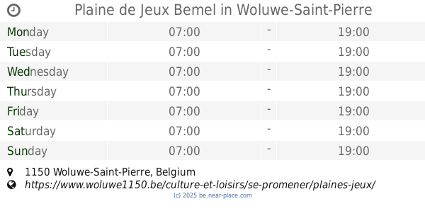
Plaine de Jeux Bemel
Woluwe-Saint-Pierre
Park
read more
14.633 km
Speelplein Tomberg
Woluwe-Saint-Lambert
Park
read more
14.711 km
Berger-Draye
Rue aux Fleurs 9, Ottignies-Louvain-la-Neuve
Park
read more
15.307 km
Champ Sophie Charlier
Waterloo
Park
read more
16.258 km
Parc communal Jules Descampe
Rue René Dewit, Waterloo
Park
read more
18.125 km
Observatoire de Napoléon
Lasne
Park
read more
📑
all categories
Accounting
Administrative area level 1
Administrative area level 2
Airport
Amusement park
Aquarium
Art gallery
Atm
Bakery
Bank
Bar
Beauty salon
Bicycle store
Book store
Bowling alley
Bus station
Cafe
Campground
Car dealer
Car rental
Car repair
Car wash
Casino
Cemetery
Church
City hall
Clothing store
Colloquial area
Convenience store
Country
Courthouse
Dentist
Department store
Doctor
Electrician
Electronics store
Embassy
Finance
Fire station
Florist
Food
Funeral home
Furniture store
Gas station
General contractor
Grocery or supermarket
Gym
Hair care
Hardware store
Health
Hindu Temple
Home goods store
Hospital
Insurance agency
Jewelry store
Laundry
Lawyer
Library
Light rail station
Liquor store
Local government office
Locality
Locksmith
Lodging
Meal delivery
Meal takeaway
Mosque
Movie rental
Movie theater
Moving company
Museum
Natural feature
Neighborhood
Night club
Painter
Park
Parking
Pet store
Pharmacy
Physiotherapist
Place of worship
Plumber
Point of interest
Police
Political
Post office
Premise
Real estate agency
Restaurant
Roofing contractor
Route
Rv park, camping
School
Shoe store
Shopping mall
Spa
Stadium
Storage
Store
Subpremise
Subway station
Supermarket
Synagogue
Taxi stand
Train station
Transit station
Travel agency
University
Veterinary care
Zoo
sublocality level 1
sublocality level 2
sublocality level 3
↑