Park nearby Forêt De Soigné
Belgium
Park nearby Forêt De Soigné
Forêt De Soigné
Auderghem Bélgica
contacts phone
:
+32
Latitude:
50.8164064
, Longitude:
4.4265181
read more
nearest Park
Forêt De Soigné
Oudergem
Park
read more
251 m
La Sonrisa sprl
Clos du Bergoje 8, Bruxelles
Park
read more
281 m
Pro Gardener SA
Oude Molenstraat 66, Brussel
Park
read more
281 m
Pro Gardener SA
Rue du Vieux Moulin 66, Bruxelles
Park
read more
286 m
Compost de quartier Villageois
Rue du Villageois 91, Auderghem
Park
read more
520 m
Speelplein Coulbaut
Oudergem
Park
read more
520 m
Plaine de Jeux Coulbaut
Auderghem
Park
read more
892 m
Domain Park of Val Duchesse
Auderghem
Park
read more
909 m
Experimental Jean Massart Botanical Garden - ULB
1850, Waversesteenweg, Oudergem
Park
read more
994 m
Place des Bouvreuils
Place des Bouvreuils, Woluwé-Saint-Pierre, Brussels Region 1150
Park
read more
1.266 km
Plaine de Jeux Freres Legrain - Chant d'Oiseau
Woluwe-Saint-Pierre
Park
read more
1.331 km
Plaine de Jeux Mellaerts
Woluwe-Saint-Pierre
Park
read more
1.336 km
Speelplein De Franciskanen
Sint-Pieters-Woluwe
Park
read more
1.336 km
Plaine de Jeux les Franciscains
Woluwe-Saint-Pierre
Park
read more
1.369 km
Mellaertsvijvers
Woluwe-Saint-Pierre
Park
read more
1.675 km
Plaine de Jeux Tercoigne
Watermael-Boitsfort
Park
read more
1.682 km
Parc Parmentier
Woluwe-Saint-Pierre
Park
read more
1.682 km
Parmentierpark
Woluwe-Saint-Pierre
Park
read more
1.688 km
Parc Tercoigne
Watermael-Boitsfort
Park
read more
1.743 km
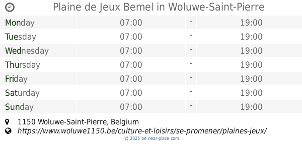
Plaine de Jeux Bemel
Woluwe-Saint-Pierre
Park
read more
1.761 km
Escale des Trois Fontaines
Auderghem
Park
read more
1.807 km
Elemen'Terre
Rue Théophile Vander Elst 160, Bruxelles
Park
read more
2.104 km
Plaine de Jeux Venelles II
Woluwe-Saint-Pierre
Park
read more
2.104 km
Plaine de Jeux Venelles I
Woluwe-Saint-Pierre
Park
read more
2.406 km
Plaine de Jeux Van Genegen
Woluwe-Saint-Pierre
Park
read more
📑
all categories
Accounting
Administrative area level 1
Administrative area level 2
Airport
Amusement park
Aquarium
Art gallery
Atm
Bakery
Bank
Bar
Beauty salon
Bicycle store
Book store
Bowling alley
Bus station
Cafe
Campground
Car dealer
Car rental
Car repair
Car wash
Casino
Cemetery
Church
City hall
Clothing store
Colloquial area
Convenience store
Country
Courthouse
Dentist
Department store
Doctor
Electrician
Electronics store
Embassy
Finance
Fire station
Florist
Food
Funeral home
Furniture store
Gas station
General contractor
Grocery or supermarket
Gym
Hair care
Hardware store
Health
Hindu Temple
Home goods store
Hospital
Insurance agency
Jewelry store
Laundry
Lawyer
Library
Light rail station
Liquor store
Local government office
Locality
Locksmith
Lodging
Meal delivery
Meal takeaway
Mosque
Movie rental
Movie theater
Moving company
Museum
Natural feature
Neighborhood
Night club
Painter
Park
Parking
Pet store
Pharmacy
Physiotherapist
Place of worship
Plumber
Point of interest
Police
Political
Post office
Premise
Real estate agency
Restaurant
Roofing contractor
Route
Rv park, camping
School
Shoe store
Shopping mall
Spa
Stadium
Storage
Store
Subpremise
Subway station
Supermarket
Synagogue
Taxi stand
Train station
Transit station
Travel agency
University
Veterinary care
Zoo
sublocality level 1
sublocality level 2
sublocality level 3
↑