Park nearby Dijlebrug Wandelpad
Belgium
Park nearby Dijlebrug Wandelpad
Dijlebrug Wandelpad
Rotselaar Bélgica
contacts phone
:
+32
Latitude:
50.9683997
, Longitude:
4.6928509
read more
nearest Park
467 m
Werchter Park
Haachtsesteenweg 13-9, Rotselaar
Park
read more
832 m
Andy Cumps Tuinarchitectuur AC Tuinen
Rochusstraat 42, Rotselaar
Park
read more
2.295 km
Natuurdomein Ter Heide
Vakenstraat 18, Rotselaar
Park
read more
2.295 km
Nature Preserve Ter Heide
Vakenstraat 18, Rotselaar
Park
read more
2.46 km
De Slag bij de Molen in Rotselaar
Vijfde Liniestraat 77, Rotselaar
Park
read more
2.534 km
Gardenstate
Duivenbergstraat 13, Tremelo
Park
read more
3.004 km
De Gevel
Molenstraat 38-46,3110, Rotselaar
Park
read more
3.409 km
Wijgmaalbroek Natuurpunt
Wijgmaalbroek 93, Leuven
Park
read more
3.564 km
Natuurgebied Kruisheide
Mwami Mutaradreef, Keerbergen
Park
read more
3.638 km
Heerlyckheid van Roost
Roostweg, Haacht
Park
read more
3.841 km
Antitankgracht
Roostweg 7, Haacht
Park
read more
4.213 km
D&T
Mercatorlaan 14, Haacht
Park
read more
4.26 km
Arboretum Wespelaar
Grote Baan 63, Haacht
Park
read more
4.294 km
Herdenkingsbos
Elfde Linielaan, Haacht
Park
read more
4.832 km
broedplaats oostindische boskarakiet (Oizo - Swasoo)
Grote Appelstraat 71-85, Haacht
Park
read more
4.902 km
Concor Facility Services NV
Gerzevien 25, Haacht
Park
read more
4.998 km
Natuurpark wijgmaal
Remylaan, Leuven
Park
read more
5.036 km
WIJNGAARDBERG
Aarschotsesteenweg 244-250, Rotselaar
Park
read more
5.168 km
Tuinen Ceulemans
Vossekot 7, Keerbergen
Park
read more
5.169 km
Natuurgebied Bolloheide
Van Maelelaan, Tremelo
Park
read more
5.618 km
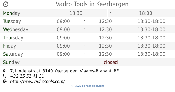
Vadro Tools
Lindenstraat 7, Keerbergen
Park
read more
5.717 km
ALL4SUN sunproof! - Zonwering & Rolluiken regio Keerbergen
Haachtsebaan 57, Keerbergen
Park
read more
5.964 km
Natuurpunt Broekelei
Broekelei 3140, Keerbergen
Park
read more
9.454 km
b-Tree Boomverzorging
Bareelstraat 76a, Putte
Park
read more
10.275 km
Vdb Tuinen, Agriculture
Steenstraat 8, Beerzel
Park
read more
📑
all categories
Accounting
Administrative area level 1
Administrative area level 2
Airport
Amusement park
Aquarium
Art gallery
Atm
Bakery
Bank
Bar
Beauty salon
Bicycle store
Book store
Bowling alley
Bus station
Cafe
Campground
Car dealer
Car rental
Car repair
Car wash
Casino
Cemetery
Church
City hall
Clothing store
Colloquial area
Convenience store
Country
Courthouse
Dentist
Department store
Doctor
Electrician
Electronics store
Embassy
Finance
Fire station
Florist
Food
Funeral home
Furniture store
Gas station
General contractor
Grocery or supermarket
Gym
Hair care
Hardware store
Health
Hindu Temple
Home goods store
Hospital
Insurance agency
Jewelry store
Laundry
Lawyer
Library
Light rail station
Liquor store
Local government office
Locality
Locksmith
Lodging
Meal delivery
Meal takeaway
Mosque
Movie rental
Movie theater
Moving company
Museum
Natural feature
Neighborhood
Night club
Painter
Park
Parking
Pet store
Pharmacy
Physiotherapist
Place of worship
Plumber
Point of interest
Police
Political
Post office
Premise
Real estate agency
Restaurant
Roofing contractor
Route
Rv park, camping
School
Shoe store
Shopping mall
Spa
Stadium
Storage
Store
Subpremise
Subway station
Supermarket
Synagogue
Taxi stand
Train station
Transit station
Travel agency
University
Veterinary care
Zoo
sublocality level 1
sublocality level 2
sublocality level 3
↑