Lodging nearby Loft lumineux Tilff-Liège
Belgium
Lodging nearby Loft lumineux Tilff-Liège
Loft lumineux Tilff-Liège
101, Avenue des Ardennes, Esneux Belgien
contacts phone
:
+32
Latitude:
50.5580848
, Longitude:
5.575559
read more
nearest Lodging
273 m
Van Ass / Guy
Rue Hayette 40, Esneux
Lodging
read more
273 m
Sébastien Van Ass
Rue Hayette 40, Esneux
Lodging
read more
898 m
Gite 26
Avenue d'Esneux, Esneux
Lodging
read more
1.038 km
Open House
Rue Ferrer 1, Esneux
Lodging
read more
1.35 km
La Bicoque du Pêcheur
Quai de l'Ourthe 5, Esneux
Lodging
read more
1.367 km
Centre de Coopération éducative
Esplanade de l'Abeille 9, Tilff
Lodging
read more
1.37 km
Tilff Youth Hostel
Esplanade de l'Abeille 9, Tilff
Lodging
read more
1.609 km
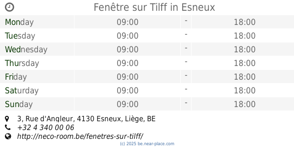
Fenêtre sur Tilff
Rue d'Angleur 3, Esneux
Lodging
read more
1.92 km
Chalet Hony Moon
Rue de Fèchereux 12/9, Hony
Lodging
read more
1.926 km
Vakantiehuis Auberge Le Barrage
4130, Rue de Fèchereux 26, Esneux
Lodging
read more
1.974 km
Hotel ibis Liège Seraing
Route du Condroz 15, Boncelles
Lodging
read more
2.305 km
cottage Au Bout Du Prez
-14 België, Devant Rosière 4, Esneux
Lodging
read more
2.305 km
gite Au Bout Du Prez
-14 België, Devant Rosière 4, Esneux
Lodging
read more
2.469 km
Chez Simone
Avenue Simonis 9, Esneux
Lodging
read more
2.92 km
Stone Station
Avenue de la Station 4, Esneux
Lodging
read more
2.99 km
Les Gallinautes
Rue des Carrières 7, Esneux
Lodging
read more
3.09 km
Gîte Marie à la campagne
Hautgné 15
Lodging
read more
3.09 km
Chez Marie
Hautgné 15
Lodging
read more
3.153 km
Malherbe / L.
Rue du Travail 36, Seraing
Lodging
read more
3.153 km
Malherbe / L.
Rue du Travail 38, Seraing
Lodging
read more
3.746 km
Black&White
Sur les Huts 19, Chaudfontaine
Lodging
read more
4.372 km
Le Val D'ourthe
Rue de Tilff 412
Lodging
read more
4.466 km
L'Orchidee Blanche Hotel
Route du Condroz 151, Angleur
Lodging
read more
4.521 km
Orchidée blanche
Route du Condroz 151, Angleur
Lodging
read more
5.779 km
Urban Lodge
Esplanade 2, Chaudfontaine
Lodging
read more
📑
all categories
Accounting
Administrative area level 1
Administrative area level 2
Airport
Amusement park
Aquarium
Art gallery
Atm
Bakery
Bank
Bar
Beauty salon
Bicycle store
Book store
Bowling alley
Bus station
Cafe
Campground
Car dealer
Car rental
Car repair
Car wash
Casino
Cemetery
Church
City hall
Clothing store
Colloquial area
Convenience store
Country
Courthouse
Dentist
Department store
Doctor
Electrician
Electronics store
Embassy
Finance
Fire station
Florist
Food
Funeral home
Furniture store
Gas station
General contractor
Grocery or supermarket
Gym
Hair care
Hardware store
Health
Hindu Temple
Home goods store
Hospital
Insurance agency
Jewelry store
Laundry
Lawyer
Library
Light rail station
Liquor store
Local government office
Locality
Locksmith
Lodging
Meal delivery
Meal takeaway
Mosque
Movie rental
Movie theater
Moving company
Museum
Natural feature
Neighborhood
Night club
Painter
Park
Parking
Pet store
Pharmacy
Physiotherapist
Place of worship
Plumber
Point of interest
Police
Political
Post office
Premise
Real estate agency
Restaurant
Roofing contractor
Route
Rv park, camping
School
Shoe store
Shopping mall
Spa
Stadium
Storage
Store
Subpremise
Subway station
Supermarket
Synagogue
Taxi stand
Train station
Transit station
Travel agency
University
Veterinary care
Zoo
sublocality level 1
sublocality level 2
sublocality level 3
↑