Lodging nearby De Maaier
Belgium
Lodging nearby De Maaier
De Maaier
Brugstraat 21, Hasselt Belgique
contacts phone
:
+32
Latitude:
50.9440681
, Longitude:
5.3864517
read more
nearest Lodging
122 m
Bed and Bubbles
Brugstraat 38, Hasselt
Lodging
read more
232 m
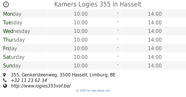
Kamers Logies 355
Genkersteenweg 355, Hasselt
Lodging
read more
232 m
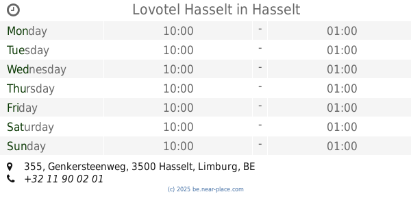
Lovotel Hasselt
Genkersteenweg 355, Hasselt
Lodging
read more
312 m
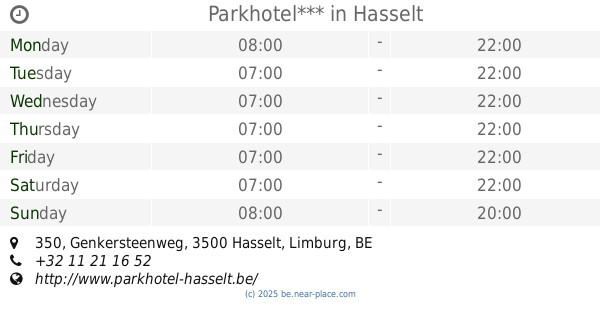
Parkhotel***
Genkersteenweg 350, Hasselt
Lodging
read more
422 m
Dai Hotel
Genkersteenweg 350, Hasselt
Lodging
read more
1.299 km
Bij Lieve en Jos
Heidestraat 51, Hasselt
Lodging
read more
1.299 km
B&B Bij Lieve en Jos
Heidestraat 51, Hasselt
Lodging
read more
1.371 km
Vanderheyden / Godelieve
Heidestraat 51, Hasselt
Lodging
read more
1.806 km
Bokrijks Gasthof
Hasseltweg 475, Genk
Lodging
read more
1.813 km
Belle Hotel - Bokrijk
bus 2,, Hasseltweg 475, Genk
Lodging
read more
1.817 km
B&B De Kiezel Hasselt
Kiezelstraat 71, Hasselt
Lodging
read more
1.854 km
Le refuge Hotel b&b
Kiewitstraat 247, Hasselt
Lodging
read more
1.854 km
Le Refuge
Kiewitstraat 247, Hasselt
Lodging
read more
1.977 km
Parking
Genk
Lodging
read more
2.013 km
Provincaal Domein Genk
Bokrijklaan 1, Genk
Lodging
read more
2.228 km
Cupido
Hasseltweg 441, Genk
Lodging
read more
2.407 km
Tom / Billen
Maastrichtersteenweg 366, Hasselt
Lodging
read more
2.47 km
B&B De Epicurist
Tulpinstraat 39, Hasselt, Hasselt
Lodging
read more
2.532 km
Wellness Hasselt b & b
Tulpinstraat 33, Hasselt
Lodging
read more
2.532 km
Wellness Hasselt b&b
Tulpinstraat 33, Hasselt
Lodging
read more
2.929 km
Maison Stout
2, Genkersteenweg, Hasselt
Lodging
read more
3.045 km
Unique mansion
Maastrichtersteenweg 79, Hasselt
Lodging
read more
3.121 km
'T Prieeltje
Alfons Jeurissenstraat 75, Diepenbeek
Lodging
read more
3.378 km
taxandria center
Gouverneur Roppesingel, Hasselt
Lodging
read more
3.881 km
Jo-Li
Ganzebroekstraat 13, Diepenbeek
Lodging
read more
📑
all categories
Accounting
Administrative area level 1
Administrative area level 2
Airport
Amusement park
Aquarium
Art gallery
Atm
Bakery
Bank
Bar
Beauty salon
Bicycle store
Book store
Bowling alley
Bus station
Cafe
Campground
Car dealer
Car rental
Car repair
Car wash
Casino
Cemetery
Church
City hall
Clothing store
Colloquial area
Convenience store
Country
Courthouse
Dentist
Department store
Doctor
Electrician
Electronics store
Embassy
Finance
Fire station
Florist
Food
Funeral home
Furniture store
Gas station
General contractor
Grocery or supermarket
Gym
Hair care
Hardware store
Health
Hindu Temple
Home goods store
Hospital
Insurance agency
Jewelry store
Laundry
Lawyer
Library
Light rail station
Liquor store
Local government office
Locality
Locksmith
Lodging
Meal delivery
Meal takeaway
Mosque
Movie rental
Movie theater
Moving company
Museum
Natural feature
Neighborhood
Night club
Painter
Park
Parking
Pet store
Pharmacy
Physiotherapist
Place of worship
Plumber
Point of interest
Police
Political
Post office
Premise
Real estate agency
Restaurant
Roofing contractor
Route
Rv park, camping
School
Shoe store
Shopping mall
Spa
Stadium
Storage
Store
Subpremise
Subway station
Supermarket
Synagogue
Taxi stand
Train station
Transit station
Travel agency
University
Veterinary care
Zoo
sublocality level 1
sublocality level 2
sublocality level 3
↑