Local government office nearby Mairie
Belgium
Local government office nearby Mairie
Mairie
84 Rue du Chemin Vert, Neuville-en-Ferrain Belgium
contacts phone
:
+32
Latitude:
50.7529256
, Longitude:
3.169004
read more
nearest Local government office
1.043 km
Administration générale de la Fiscalité
Schermutselingstraat 45, Moeskroen
Local government office
read more
1.043 km
Administration générale de la Fiscalité
Rue de l'Echauffourée 45, Mouscron
Local government office
read more
1.154 km
École
29 Rue du Gallodrome, Neuville-en-Ferrain
Local government office
read more
1.363 km
Mairie (Salles de sport)
102 Rue Robert Schumann, Tourcoing
Local government office
read more
2.019 km
Mairie (Salles de sport)
40 Rue de Varsovie, Tourcoing
Local government office
read more
2.253 km
Salle Maurice Heddebaut
119 Rue Ingres, Tourcoing
Local government office
read more
2.267 km
Car Transit International
57 Avenue de l'Europe, Roncq
Local government office
read more
3.131 km
Syndicat CFDT
52 Rue du Calvaire, Tourcoing
Local government office
read more
3.137 km
Darmanin Gérald
103 Rue Fin de la Guerre, Tourcoing
Local government office
read more
3.175 km
Halte-garderie L'Île aux enfants (Mairie de Tourcoing Halte-garderie)
38 Avenue Jean Millet, Tourcoing
Local government office
read more
3.206 km
Centre Communal Action sociale
26 Rue de la Bienfaisance, Tourcoing
Local government office
read more
3.211 km
Mairie
25 Rue Desurmont Louis-François, Tourcoing
Local government office
read more
3.384 km
City Permis
10 Rue du Général Leclerc, Tourcoing
Local government office
read more
3.471 km
Start People Tourcoing
14 Rue de la Cloche, Tourcoing
Local government office
read more
3.664 km
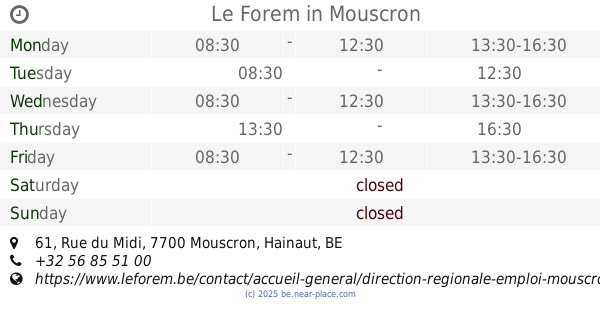
Le Forem
Rue du Midi 61, Mouscron
Local government office
read more
3.832 km
Mairie
74 Rue de Boulogne, Wattrelos
Local government office
read more
3.981 km
Carte grise
64 Avenue Alfred Lefrançois, Tourcoing
Local government office
read more
4.051 km
QUARTA Désamiantage
112 Rue d'Hondschoote, Tourcoing
Local government office
read more
4.22 km
Vincent LEDOUX
195 Rue de Paris, Tourcoing
Local government office
read more
4.625 km
Commune d'Halluin
71 Rue Jean Jaurès, Halluin
Local government office
read more
4.633 km
Departement Du Nord
3 Rue des Quais, Tourcoing
Local government office
read more
4.638 km
Mairie
574 Rue de Tourcoing, Mouvaux
Local government office
read more
5.156 km
Notre Logis
221 Rue de la Lys, Halluin
Local government office
read more
5.88 km
Stadhuis Menen
Grote Markt 1, Menen
Local government office
read more
6.226 km
VDAB Werkwinkel Menen
Wervikstraat 186, Menen
Local government office
read more
📑
all categories
Accounting
Administrative area level 1
Administrative area level 2
Airport
Amusement park
Aquarium
Art gallery
Atm
Bakery
Bank
Bar
Beauty salon
Bicycle store
Book store
Bowling alley
Bus station
Cafe
Campground
Car dealer
Car rental
Car repair
Car wash
Casino
Cemetery
Church
City hall
Clothing store
Colloquial area
Convenience store
Country
Courthouse
Dentist
Department store
Doctor
Electrician
Electronics store
Embassy
Finance
Fire station
Florist
Food
Funeral home
Furniture store
Gas station
General contractor
Grocery or supermarket
Gym
Hair care
Hardware store
Health
Hindu Temple
Home goods store
Hospital
Insurance agency
Jewelry store
Laundry
Lawyer
Library
Light rail station
Liquor store
Local government office
Locality
Locksmith
Lodging
Meal delivery
Meal takeaway
Mosque
Movie rental
Movie theater
Moving company
Museum
Natural feature
Neighborhood
Night club
Painter
Park
Parking
Pet store
Pharmacy
Physiotherapist
Place of worship
Plumber
Point of interest
Police
Political
Post office
Premise
Real estate agency
Restaurant
Roofing contractor
Route
Rv park, camping
School
Shoe store
Shopping mall
Spa
Stadium
Storage
Store
Subpremise
Subway station
Supermarket
Synagogue
Taxi stand
Train station
Transit station
Travel agency
University
Veterinary care
Zoo
sublocality level 1
sublocality level 2
sublocality level 3
↑