Gas station nearby Station Ceyssens
Belgium
Gas station nearby Station Ceyssens
Station Ceyssens
Genkerbaan 18, Meeuwen Belgium
contacts phone
:
+32
Latitude:
51.0896807
, Longitude:
5.5246137
read more
nearest Gas station
5.789 km
Gulf - Garage Baeten Nv
Weg naar Bree 96, Opglabbeek
Gas station
read more
6.519 km
Total
Weg naar Zwartberg 291, Opglabbeek
Gas station
read more
8.547 km
Decabooter Roger
Weg naar Zwartberg 68, Houthalen-Helchteren
Gas station
read more
8.868 km
Gulf
Koning Boudewijnlaan 75, Genk
Gas station
read more
9.17 km
H&Y Oil B.v.b.a.
Jagersdreef 1, As
Gas station
read more
9.528 km
Esso
Hoevenzavellaan 111, Genk
Gas station
read more
10.286 km
Gulf
Guillaume Lambertlaan 9, Genk
Gas station
read more
10.43 km
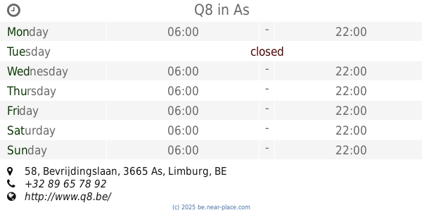
Q8
Bevrijdingslaan 58, As
Gas station
read more
10.471 km
Esso
Steenweg 103, As
Gas station
read more
10.714 km
Van Raak - Houthalen
Weg naar Zwartberg 1, Houthalen-Helchteren
Gas station
read more
10.902 km
Esso Bruno
Henri Esserslaan 10, Genk
Gas station
read more
10.906 km
Esso
Hermeslaan 60, Genk
Gas station
read more
12.133 km
Lukoil
Weg naar As 290, Genk
Gas station
read more
12.214 km
Octa+ Carwash
Spilstraat 47, Maaseik
Gas station
read more
12.214 km
Octa+
Spilstraat 47, Maaseik
Gas station
read more
12.937 km
Q8
Grote Baan 11, Houthalen-Helchteren
Gas station
read more
13.299 km
Van Raak - Maasmechelen
Steenweg naar As 16, Maasmechelen
Gas station
read more
13.856 km
Esso
Lillosteenweg 75, Houthalen
Gas station
read more
14.043 km
Total
Vennestraat 258, Genk
Gas station
read more
15.799 km
Q8
Hasseltweg 345, Genk
Gas station
read more
16.446 km
Ilba bvba
Rijksweg 151, Dilsen-Stokkem
Gas station
read more
16.765 km
Shell
Oude Baan 168, Maasmechelen
Gas station
read more
17.391 km
Sevens Service Station NV
Astridlaan 278/2, Overpelt
Gas station
read more
17.55 km
Shell
Heuveneindeweg 80, N74, Zonhoven
Gas station
read more
20.933 km
Q8
Stationsstraat 86, Lommel
Gas station
read more
📑
all categories
Accounting
Administrative area level 1
Administrative area level 2
Airport
Amusement park
Aquarium
Art gallery
Atm
Bakery
Bank
Bar
Beauty salon
Bicycle store
Book store
Bowling alley
Bus station
Cafe
Campground
Car dealer
Car rental
Car repair
Car wash
Casino
Cemetery
Church
City hall
Clothing store
Colloquial area
Convenience store
Country
Courthouse
Dentist
Department store
Doctor
Electrician
Electronics store
Embassy
Finance
Fire station
Florist
Food
Funeral home
Furniture store
Gas station
General contractor
Grocery or supermarket
Gym
Hair care
Hardware store
Health
Hindu Temple
Home goods store
Hospital
Insurance agency
Jewelry store
Laundry
Lawyer
Library
Light rail station
Liquor store
Local government office
Locality
Locksmith
Lodging
Meal delivery
Meal takeaway
Mosque
Movie rental
Movie theater
Moving company
Museum
Natural feature
Neighborhood
Night club
Painter
Park
Parking
Pet store
Pharmacy
Physiotherapist
Place of worship
Plumber
Point of interest
Police
Political
Post office
Premise
Real estate agency
Restaurant
Roofing contractor
Route
Rv park, camping
School
Shoe store
Shopping mall
Spa
Stadium
Storage
Store
Subpremise
Subway station
Supermarket
Synagogue
Taxi stand
Train station
Transit station
Travel agency
University
Veterinary care
Zoo
sublocality level 1
sublocality level 2
sublocality level 3
↑