Gas station nearby Shell
Belgium
Gas station nearby Shell
Shell
Sittarder Straße 42, Selfkant Belgium
contacts phone
:
+32
Latitude:
51.0142422
, Longitude:
5.9010296
read more
nearest Gas station
2.183 km
Shell
Dokter Nolenslaan 67, Sittard
Gas station
read more
2.239 km
Tinq
Tudderenderweg 53, Sittard
Gas station
read more
2.701 km
Autohaus Schüren
Hauptstraße, Selfkant
Gas station
read more
2.778 km
SB Tankstelle, Hauptstraße, Selfkant, Duitsland
Hauptstraße, Selfkant
Gas station
read more
3.397 km
Shell
Leyenbroekerweg 102, Sittard
Gas station
read more
3.519 km
AVIA XPress Nieuwstadt
Gouverneur Houbenstraat 1, Nieuwstadt
Gas station
read more
3.53 km
De Tenk
Gouverneur Houbenstraat 1, Nieuwstadt
Gas station
read more
3.57 km
AVIA Truck Sittard
Op de Baan 11, Nieuwstadt
Gas station
read more
4.232 km
Servicepunt Veders @ LUKOIL Sittard
Industriestraat 3, Sittard
Gas station
read more
4.239 km
LUKOIL Sittard
Industriestraat 3, Sittard
Gas station
read more
4.452 km
Shell
Sittard
Gas station
read more
4.732 km
Esso
Windraak 24a, Windraak
Gas station
read more
5.123 km
OrangeGas
Middenweg 100, Sittard
Gas station
read more
5.124 km
BP
Middenweg 100, Sittard
Gas station
read more
5.463 km
Esso
Langereweg 17, Born
Gas station
read more
5.519 km
Wenmaekers
Langereweg 17, Born
Gas station
read more
5.86 km
AVIA XPress Geleen
Rijksweg Noord 125, Geleen
Gas station
read more
9.487 km
Firezone
Rijksweg Noord 3, Echt
Gas station
read more
12.245 km
Ilba bvba
Rijksweg 151, Dilsen-Stokkem
Gas station
read more
12.427 km
Esso
Maastrichterstwg 168, Maaseik B
Gas station
read more
15.013 km
Shell
Oude Baan 168, Maasmechelen
Gas station
read more
16.367 km
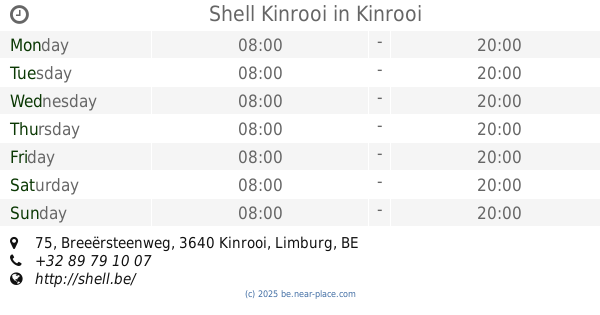
Shell Kinrooi
Breeërsteenweg 75, Kinrooi
Gas station
read more
16.659 km
Octa+
Spilstraat 47, Maaseik
Gas station
read more
18.065 km
Gabriëls
Weertersteenweg 138, Kinrooi
Gas station
read more
18.199 km
Exploitatiemaatschappij De Beaufort B.V.
Maastrichterweg 12, Meerssen
Gas station
read more
📑
all categories
Accounting
Administrative area level 1
Administrative area level 2
Airport
Amusement park
Aquarium
Art gallery
Atm
Bakery
Bank
Bar
Beauty salon
Bicycle store
Book store
Bowling alley
Bus station
Cafe
Campground
Car dealer
Car rental
Car repair
Car wash
Casino
Cemetery
Church
City hall
Clothing store
Colloquial area
Convenience store
Country
Courthouse
Dentist
Department store
Doctor
Electrician
Electronics store
Embassy
Finance
Fire station
Florist
Food
Funeral home
Furniture store
Gas station
General contractor
Grocery or supermarket
Gym
Hair care
Hardware store
Health
Hindu Temple
Home goods store
Hospital
Insurance agency
Jewelry store
Laundry
Lawyer
Library
Light rail station
Liquor store
Local government office
Locality
Locksmith
Lodging
Meal delivery
Meal takeaway
Mosque
Movie rental
Movie theater
Moving company
Museum
Natural feature
Neighborhood
Night club
Painter
Park
Parking
Pet store
Pharmacy
Physiotherapist
Place of worship
Plumber
Point of interest
Police
Political
Post office
Premise
Real estate agency
Restaurant
Roofing contractor
Route
Rv park, camping
School
Shoe store
Shopping mall
Spa
Stadium
Storage
Store
Subpremise
Subway station
Supermarket
Synagogue
Taxi stand
Train station
Transit station
Travel agency
University
Veterinary care
Zoo
sublocality level 1
sublocality level 2
sublocality level 3
↑