Gas station nearby Q8 easy
Belgium
Gas station nearby Q8 easy
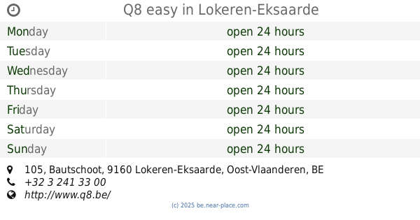
Q8 easy
116, Bergendriesstraat, 9160, Lokeren, Oost-Vlaanderen, BE Belgique
contacts phone
:
+32 3 241 33 00
website:
www.q8.be
Latitude:
51.1129237
, Longitude:
3.9879232
larger map & directions
read more
nearest Gas station
123 m
Lukoil Lokeren
Bergendriesstraat 75, Lokeren
Gas station
read more
1.188 km
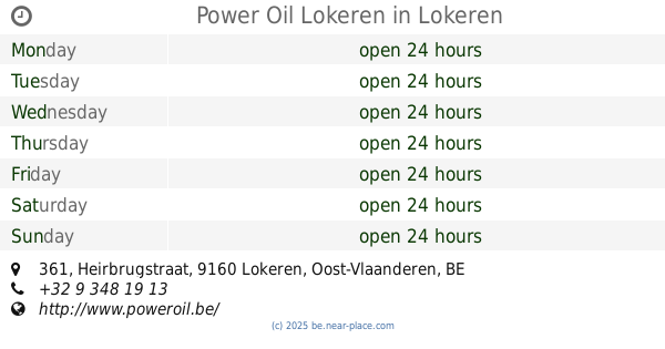
Power Oil Lokeren
Heirbrugstraat 361, Lokeren
Gas station
read more
1.539 km
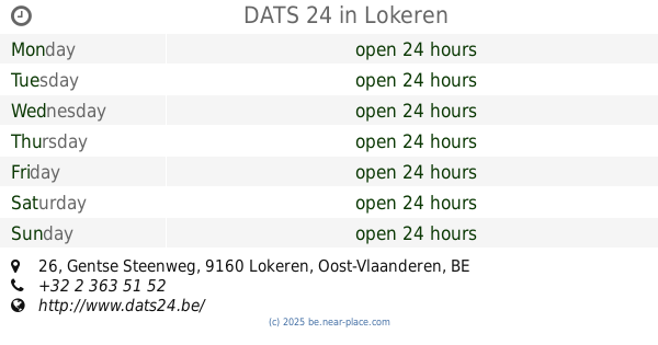
DATS 24
Gentse Steenweg 26, Lokeren
Gas station
read more
1.801 km
Esso
Gentse Steenweg 58, Lokeren
Gas station
read more
2.55 km
AVIA N47-Zelebaan (zuid)
Zelebaan 25, Lokeren
Gas station
read more
2.602 km
Q8
Zelebaan 33, Lokeren
Gas station
read more
2.638 km
Total
Zelebaan 39-41, Lokeren
Gas station
read more
2.703 km
Dats24 Lokeren
Zelebaan 100, Lokeren
Gas station
read more
2.735 km
AVIA Heiende
Hillarestraat 123-129, Lokeren
Gas station
read more
3.231 km
Texaco
Zelebaan 91, Lokeren
Gas station
read more
3.25 km
tankpool24
Zelebaan 91, Lokeren
Gas station
read more
3.276 km
Bel Lokeren AS24
9160, Lokeren
Gas station
read more
3.278 km
AS24
Dijkstraat, Lokeren
Gas station
read more
3.279 km
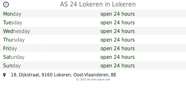
AS 24 Lokeren
Dijkstraat 18, Lokeren
Gas station
read more
3.44 km
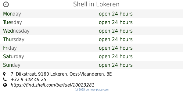
Shell
Dijkstraat 7, Lokeren
Gas station
read more
3.532 km
Q8 easy
Bautschoot 105, Lokeren-Eksaarde
Gas station
read more
3.661 km
AVIA
Bautschoot 101, Lokeren
Gas station
read more
5.082 km
Vercauteren
Zwaanaardestraat, Sint-Niklaas
Gas station
read more
5.083 km
Gas station Vercauteren bvba
Zwaanaardestraat 137, Sinaai-Waas
Gas station
read more
5.096 km
Nafta
Zwaanaardestraat 137, Klein Sinaai
Gas station
read more
5.787 km
Gabriel Zele Industry
Dommekensstraat 5, Zele
Gas station
read more
6.53 km
Total
Gent, E17 Antwerpen, Laarne
Gas station
read more
6.535 km
Total
E17 Antwerpen-gent, Laarne
Gas station
read more
6.713 km
Total
E17 Gent-Antwerpen, Laarne
Gas station
read more
6.713 km
Total Kalken E17 richting Antwerpen
E17 Gent-Antwerpen, Laarne
Gas station
read more
📑
all categories
Accounting
Administrative area level 1
Administrative area level 2
Airport
Amusement park
Aquarium
Art gallery
Atm
Bakery
Bank
Bar
Beauty salon
Bicycle store
Book store
Bowling alley
Bus station
Cafe
Campground
Car dealer
Car rental
Car repair
Car wash
Casino
Cemetery
Church
City hall
Clothing store
Colloquial area
Convenience store
Country
Courthouse
Dentist
Department store
Doctor
Electrician
Electronics store
Embassy
Finance
Fire station
Florist
Food
Funeral home
Furniture store
Gas station
General contractor
Grocery or supermarket
Gym
Hair care
Hardware store
Health
Hindu Temple
Home goods store
Hospital
Insurance agency
Jewelry store
Laundry
Lawyer
Library
Light rail station
Liquor store
Local government office
Locality
Locksmith
Lodging
Meal delivery
Meal takeaway
Mosque
Movie rental
Movie theater
Moving company
Museum
Natural feature
Neighborhood
Night club
Painter
Park
Parking
Pet store
Pharmacy
Physiotherapist
Place of worship
Plumber
Point of interest
Police
Political
Post office
Premise
Real estate agency
Restaurant
Roofing contractor
Route
Rv park, camping
School
Shoe store
Shopping mall
Spa
Stadium
Storage
Store
Subpremise
Subway station
Supermarket
Synagogue
Taxi stand
Train station
Transit station
Travel agency
University
Veterinary care
Zoo
sublocality level 1
sublocality level 2
sublocality level 3
↑