Gas station nearby Gabriel Oudenaarde
Belgium
Gas station nearby Gabriel Oudenaarde
Gabriel Oudenaarde
Wijnendale 89, Oudenaarde Belgia
contacts phone
:
+32
Latitude:
50.8448841
, Longitude:
3.6193064
read more
nearest Gas station
Gabriëls
Wijnendale 89, Oudenaarde
Gas station
read more
1.509 km
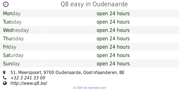
Q8 easy
Meerspoort 51, Oudenaarde
Gas station
read more
1.612 km
Esso
Gentstraat 71, Oudenaarde
Gas station
read more
1.634 km
Octa+ Oudenaarde
Kerzelare 92, Oudenaarde
Gas station
read more
2.046 km
Esso
13, Westerring Ronseweg, Oudenaarde
Gas station
read more
2.077 km
Q8
Deinzestraat 61, Oudenaarde
Gas station
read more
2.121 km
Total
Deinzestraat 63, Oudenaarde
Gas station
read more
2.565 km
devie Meersman
Kapittelstraat 26, Oudenaarde
Gas station
read more
2.88 km
diesel card belgium NV
Industriepark de Bruwaan 5A, Oudenaarde
Gas station
read more
3.126 km
Lukoil
Deinzestraat 163, Oudenaarde
Gas station
read more
3.156 km
Garage Schiettecatte Jean
Nederenamestraat 260, Oudenaarde
Gas station
read more
3.158 km
Q8
Nederenamestraat 262, Oudenaarde
Gas station
read more
3.434 km
Gabriëls Maarkedal
Maarkeweg 9, Maarkedal
Gas station
read more
3.767 km
Q8
Graaf van Landaststraat 160, Oudenaarde
Gas station
read more
3.962 km
Brandstoffen De Coninck
Gentsesteenweg, Oudenaarde
Gas station
read more
7.072 km
Shell
Gentsesteenweg 50, Zingem
Gas station
read more
7.415 km
Total
Gentsesteenweg 68, Zingem
Gas station
read more
9.633 km
Vrij/Libre
Molenstraat 86, Gavere
Gas station
read more
10.526 km
GLA Servicestations
Ninovestraat 37, Ronse
Gas station
read more
11.27 km
Total
Olsensesteenweg 64, Kruishoutem
Gas station
read more
11.326 km
Gabriëls
Industrielaan 2, Brakel
Gas station
read more
11.42 km
Lukoil RONSE
Chaussée de Leuze 1, Renaix
Gas station
read more
12.205 km
Gabriëls
Brusselsestraat 146, Brakel
Gas station
read more
13.14 km
Power
F. Rooseveltlaan 102, Waregem
Gas station
read more
15.662 km
De vos
Kortrijksesteenweg 276, Deinze
Gas station
read more
📑
all categories
Accounting
Administrative area level 1
Administrative area level 2
Airport
Amusement park
Aquarium
Art gallery
Atm
Bakery
Bank
Bar
Beauty salon
Bicycle store
Book store
Bowling alley
Bus station
Cafe
Campground
Car dealer
Car rental
Car repair
Car wash
Casino
Cemetery
Church
City hall
Clothing store
Colloquial area
Convenience store
Country
Courthouse
Dentist
Department store
Doctor
Electrician
Electronics store
Embassy
Finance
Fire station
Florist
Food
Funeral home
Furniture store
Gas station
General contractor
Grocery or supermarket
Gym
Hair care
Hardware store
Health
Hindu Temple
Home goods store
Hospital
Insurance agency
Jewelry store
Laundry
Lawyer
Library
Light rail station
Liquor store
Local government office
Locality
Locksmith
Lodging
Meal delivery
Meal takeaway
Mosque
Movie rental
Movie theater
Moving company
Museum
Natural feature
Neighborhood
Night club
Painter
Park
Parking
Pet store
Pharmacy
Physiotherapist
Place of worship
Plumber
Point of interest
Police
Political
Post office
Premise
Real estate agency
Restaurant
Roofing contractor
Route
Rv park, camping
School
Shoe store
Shopping mall
Spa
Stadium
Storage
Store
Subpremise
Subway station
Supermarket
Synagogue
Taxi stand
Train station
Transit station
Travel agency
University
Veterinary care
Zoo
sublocality level 1
sublocality level 2
sublocality level 3
↑