Gas station nearby Bouts Q8 Tankstation Borgloon
Belgium
Gas station nearby Bouts Q8 Tankstation Borgloon
Bouts Q8 Tankstation Borgloon
Tongersesteenweg 213, Borgloon Belgium
contacts phone
:
+32
Latitude:
50.7958267
, Longitude:
5.3666945
read more
nearest Gas station
819 m
Cordens
Tongersesteenweg 213, Borgloon
Gas station
read more
1.819 km
Gulf Kerniel
Rullecovenstraat 109, Kerniel
Gas station
read more
2.169 km
Gulf Haren (Borgloon)
Tongersesteenweg 356, Borgloon
Gas station
read more
2.169 km
Gulf
Tongersesteenweg 356, Borgloon
Gas station
read more
2.767 km
Jvp Preparations Nv( Tota)
Sint-Truidersteenweg 116, Borgloon
Gas station
read more
4.361 km
Pollet
Tongersesteenweg 360, Kortessem
Gas station
read more
6.093 km
Total
Sint-Truidersteenweg 433, Borgloon
Gas station
read more
7.007 km
Shell
Luikersteenweg 1, Tongeren
Gas station
read more
7.137 km
Bouts nv - Tongeren
Elfde-Novemberwal 36, Tongeren
Gas station
read more
7.185 km
Total
Steenweg 110, Heers
Gas station
read more
9.984 km
Esso
Tongersesteenweg 242, Brustem
Gas station
read more
10.271 km
Budget Tanking
Luikersteenweg 327, Brustem
Gas station
read more
11.024 km
Bruno's Foodcorner
Luikersteenweg 235, Sint-Truiden
Gas station
read more
11.441 km
Q8
Bilzersteenweg 54, Hoeselt
Gas station
read more
11.534 km
Total
Verbindingslaan 2, Diepenbeek
Gas station
read more
12.286 km
Coenengrachts Auto Nv
Tongersesteenweg 45, Sint-Truiden
Gas station
read more
12.55 km
Shell
Nieuwpoort 17, Sint-Truiden
Gas station
read more
13.028 km
Tielens / Benny
Grendelbaan 5, Diepenbeek
Gas station
read more
14.225 km
Lukoil HASSELT
Luikersteenweg 119, Hasselt
Gas station
read more
14.779 km
Plusquin Brandstoffen
Maastrichterstraat 205, Bilzen
Gas station
read more
15.805 km
Q8
Diestersteenweg 259, Nieuwerkerken
Gas station
read more
16.294 km
Genker Truck Shop Q8 Station
Henry Fordlaan 50, Genk
Gas station
read more
16.589 km
J.r.s- Jans Co
Kruisbosstraat 2, Bilzen
Gas station
read more
20.076 km
Total
Chaussée de Tongres 2, Liège
Gas station
read more
20.28 km
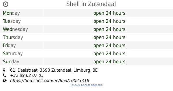
Shell
Daalstraat 61, Zutendaal
Gas station
read more
📑
all categories
Accounting
Administrative area level 1
Administrative area level 2
Airport
Amusement park
Aquarium
Art gallery
Atm
Bakery
Bank
Bar
Beauty salon
Bicycle store
Book store
Bowling alley
Bus station
Cafe
Campground
Car dealer
Car rental
Car repair
Car wash
Casino
Cemetery
Church
City hall
Clothing store
Colloquial area
Convenience store
Country
Courthouse
Dentist
Department store
Doctor
Electrician
Electronics store
Embassy
Finance
Fire station
Florist
Food
Funeral home
Furniture store
Gas station
General contractor
Grocery or supermarket
Gym
Hair care
Hardware store
Health
Hindu Temple
Home goods store
Hospital
Insurance agency
Jewelry store
Laundry
Lawyer
Library
Light rail station
Liquor store
Local government office
Locality
Locksmith
Lodging
Meal delivery
Meal takeaway
Mosque
Movie rental
Movie theater
Moving company
Museum
Natural feature
Neighborhood
Night club
Painter
Park
Parking
Pet store
Pharmacy
Physiotherapist
Place of worship
Plumber
Point of interest
Police
Political
Post office
Premise
Real estate agency
Restaurant
Roofing contractor
Route
Rv park, camping
School
Shoe store
Shopping mall
Spa
Stadium
Storage
Store
Subpremise
Subway station
Supermarket
Synagogue
Taxi stand
Train station
Transit station
Travel agency
University
Veterinary care
Zoo
sublocality level 1
sublocality level 2
sublocality level 3
↑