Gas station nearby AVIA XPress Echt
Belgium
Gas station nearby AVIA XPress Echt
AVIA XPress Echt
33A, Voltaweg, 6101 XK, Echt, Echt-Susteren, NL Netherlands
contacts phone
:
+31 13 595 0950
website:
avia.nl
Latitude:
51.1170734
, Longitude:
5.8848346
larger map & directions
read more
nearest Gas station
1.317 km
Esso
A2, Echt
Gas station
read more
1.448 km
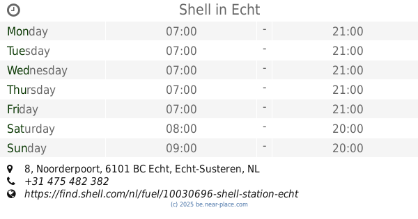
Shell
Noorderpoort 8, Echt
Gas station
read more
2.01 km
Firezone
Rijksweg Noord 3, Echt
Gas station
read more
2.046 km
tankpool24
Zuiderpoort 12, Echt
Gas station
read more
2.082 km
Esso
Zuiderpoort 12, Echt
Gas station
read more
2.271 km
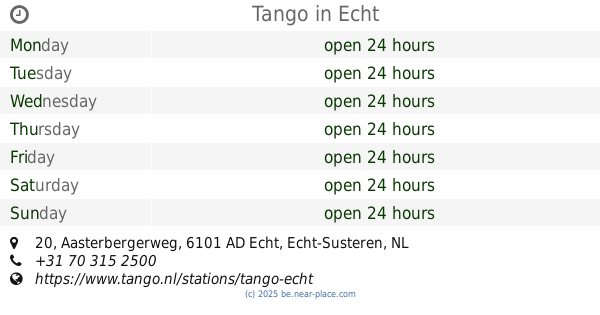
Tango
Aasterbergerweg 20, Echt
Gas station
read more
2.295 km
carpool maasbracht
Sint Joosterweg 5A, Maasbracht
Gas station
read more
2.403 km
AVIA Truck Maasbracht
Sint Joosterweg 7, Maasbracht
Gas station
read more
2.931 km
TamOil
Brugweg 8, Echt
Gas station
read more
3.241 km
Lukoil
Molenweg 50, Maasbracht
Gas station
read more
3.763 km
Firezone
Industrieweg 1, Maasbracht
Gas station
read more
4.334 km
Tank- en Service Station Beulen-Slangen V.O.F.
Rozendaalseheide 3, Montfort
Gas station
read more
4.334 km
AVIA Montfort
Rozendaalseheide 3, Montfort
Gas station
read more
4.49 km
Schreurs Wessem B.V.
Maasdijk 1, Wessem
Gas station
read more
5.061 km
Het Anker Watersport
Dalerstraat, Kinrooi
Gas station
read more
5.655 km
Tinq
Oudeweg 30, Linne
Gas station
read more
6.523 km
Verjans & zonen
Venlosesteenweg 373, Kinrooi
Gas station
read more
7.296 km
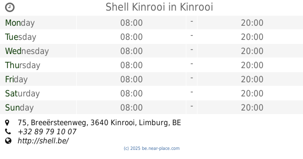
Shell Kinrooi
Breeërsteenweg 75, Kinrooi
Gas station
read more
8.979 km
Esso
Maastrichterstwg 168, Maaseik B
Gas station
read more
9.283 km
De Tenk
Gouverneur Houbenstraat 1, Nieuwstadt
Gas station
read more
10.207 km
Gabriëls
Weertersteenweg 138, Kinrooi
Gas station
read more
13.194 km
Octa+
Spilstraat 47, Maaseik
Gas station
read more
15.373 km
Total
Elsenburglaan 2, Geleen
Gas station
read more
16.022 km
Ilba bvba
Rijksweg 151, Dilsen-Stokkem
Gas station
read more
18.481 km
Esso
Ringbaan-Oost 18, Weert
Gas station
read more
📑
all categories
Accounting
Administrative area level 1
Administrative area level 2
Airport
Amusement park
Aquarium
Art gallery
Atm
Bakery
Bank
Bar
Beauty salon
Bicycle store
Book store
Bowling alley
Bus station
Cafe
Campground
Car dealer
Car rental
Car repair
Car wash
Casino
Cemetery
Church
City hall
Clothing store
Colloquial area
Convenience store
Country
Courthouse
Dentist
Department store
Doctor
Electrician
Electronics store
Embassy
Finance
Fire station
Florist
Food
Funeral home
Furniture store
Gas station
General contractor
Grocery or supermarket
Gym
Hair care
Hardware store
Health
Hindu Temple
Home goods store
Hospital
Insurance agency
Jewelry store
Laundry
Lawyer
Library
Light rail station
Liquor store
Local government office
Locality
Locksmith
Lodging
Meal delivery
Meal takeaway
Mosque
Movie rental
Movie theater
Moving company
Museum
Natural feature
Neighborhood
Night club
Painter
Park
Parking
Pet store
Pharmacy
Physiotherapist
Place of worship
Plumber
Point of interest
Police
Political
Post office
Premise
Real estate agency
Restaurant
Roofing contractor
Route
Rv park, camping
School
Shoe store
Shopping mall
Spa
Stadium
Storage
Store
Subpremise
Subway station
Supermarket
Synagogue
Taxi stand
Train station
Transit station
Travel agency
University
Veterinary care
Zoo
sublocality level 1
sublocality level 2
sublocality level 3
↑