Doctor nearby Pertry / Patrick
Belgium
Doctor nearby Pertry / Patrick
Pertry / Patrick
27, Kuipersstraat, 8000, Brugge, West-Vlaanderen, BE Belgia
contacts phone
:
+32 50 33 56 91
Latitude:
51.210574
, Longitude:
3.2229115
larger map & directions
read more
nearest Doctor
28 m
Simoens / Benedikt
Kuipersstraat 20, Brugge
Doctor
read more
145 m
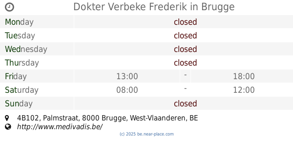
Dokter Verbeke Frederik
Palmstraat 4B102, Brugge
Doctor
read more
145 m
Dokter Verbeke Frederik (Brugge-Bruges)
Palmstraat 4B102, Brugge
Doctor
read more
213 m
Pinson / Carl
Geerwijnstraat 22, Brugge
Doctor
read more
274 m
BVBA DR. CHANTAL GEERAERTS
Moerstraat 25, Brugge
Doctor
read more
419 m
Lanckneus / Marco
Spinolarei 14, Brugge
Doctor
read more
433 m
Dokter Eddy De Moerloose
Zilverstraat 35, Brugge
Doctor
read more
447 m
Vandierendonck / Robert
Kartuizerinnenstraat 7, Brugge
Doctor
read more
456 m
Lebbe / Bruno
Beenhouwersstraat 33, Brugge
Doctor
read more
482 m
Groene Rei nv
Hertsbergestraat 6, Brugge
Doctor
read more
482 m
Van Roy Jean
Hertsbergestraat 6, Brugge
Doctor
read more
525 m
Willemot Jean
Verversdijk 19, Brugge
Doctor
read more
564 m
Ducheyne / W.
Potterierei 5, Brugge
Doctor
read more
604 m
Pintelon / Johan
Gulden-Vlieslaan 11, Brugge
Doctor
read more
611 m
Van Eeckhout / Paul
Gulden-Vlieslaan 50, Brugge
Doctor
read more
640 m
Doctor Loncke Jan - Dermatologist
Heilige-Geeststraat 13, Brugge
Doctor
read more
698 m
De Baene Luc, gynaecoloog
Filips de Goedelaan 3, Brugge
Doctor
read more
717 m
Veevaete F.
Filips de Goedelaan 8, Brugge
Doctor
read more
751 m
Floating Relax Spot
Potterierei, Brugge
Doctor
read more
790 m
Dr. Ivo Vanden Berghe
Rijkepijndersstraat 20, Brugge
Doctor
read more
809 m
Coene / Jose
Keizer Karelstraat 47, Brugge
Doctor
read more
810 m
Eye clinic 't Zand Bruges
Vrijdagmarkt 3, Brugge
Doctor
read more
843 m
Doctor's Clinic
Veldmaarschalk Fochstraat 7, Brugge
Doctor
read more
990 m
E. Van der Stichele
Langerei 66, Brugge
Doctor
read more
1.321 km
Op De Beeck / Yves
Generaal Lemanlaan 13, Brugge
Doctor
read more
📑
all categories
Accounting
Administrative area level 1
Administrative area level 2
Airport
Amusement park
Aquarium
Art gallery
Atm
Bakery
Bank
Bar
Beauty salon
Bicycle store
Book store
Bowling alley
Bus station
Cafe
Campground
Car dealer
Car rental
Car repair
Car wash
Casino
Cemetery
Church
City hall
Clothing store
Colloquial area
Convenience store
Country
Courthouse
Dentist
Department store
Doctor
Electrician
Electronics store
Embassy
Finance
Fire station
Florist
Food
Funeral home
Furniture store
Gas station
General contractor
Grocery or supermarket
Gym
Hair care
Hardware store
Health
Hindu Temple
Home goods store
Hospital
Insurance agency
Jewelry store
Laundry
Lawyer
Library
Light rail station
Liquor store
Local government office
Locality
Locksmith
Lodging
Meal delivery
Meal takeaway
Mosque
Movie rental
Movie theater
Moving company
Museum
Natural feature
Neighborhood
Night club
Painter
Park
Parking
Pet store
Pharmacy
Physiotherapist
Place of worship
Plumber
Point of interest
Police
Political
Post office
Premise
Real estate agency
Restaurant
Roofing contractor
Route
Rv park, camping
School
Shoe store
Shopping mall
Spa
Stadium
Storage
Store
Subpremise
Subway station
Supermarket
Synagogue
Taxi stand
Train station
Transit station
Travel agency
University
Veterinary care
Zoo
sublocality level 1
sublocality level 2
sublocality level 3
↑