Doctor nearby Declercq / Gabriel
Belgium
Doctor nearby Declercq / Gabriel
Declercq / Gabriel
Gistelsesteenweg 8, Brugge Belgia
contacts phone
:
+32
Latitude:
51.2038633
, Longitude:
3.2087101
read more
nearest Doctor
138 m
Cranskens / Didier
Gistelsesteenweg 61, Brugge
Doctor
read more
370 m
Depoorter / Marc
Magdalenastraat 18, Brugge
Doctor
read more
436 m
Van Loock / Elie
Gistelsesteenweg 126, Brugge
Doctor
read more
536 m
Van Maele Yvan
Legeweg 121, Brugge
Doctor
read more
578 m
Eye clinic 't Zand Bruges
Vrijdagmarkt 3, Brugge
Doctor
read more
582 m
Patrick Degomme Pediatrie
Peter Benoitlaan 58, Brugge
Doctor
read more
754 m
Dillemans Bruno
Kleine Kuipersstraat 6, Brugge
Doctor
read more
760 m
Van Belle Philip
Hans Memlinglaan 19, Brugge
Doctor
read more
767 m
Fossion / Jean-P
Jan Breydellaan 93, Brugge
Doctor
read more
810 m
Lebbe / Bruno
Beenhouwersstraat 33, Brugge
Doctor
read more
823 m
Pintelon / Johan
Gulden-Vlieslaan 11, Brugge
Doctor
read more
854 m
De Jonghe / Norbert
Legeweg 134, Brugge
Doctor
read more
927 m
Dokter Eddy De Moerloose
Zilverstraat 35, Brugge
Doctor
read more
966 m
BVBA DR. CHANTAL GEERAERTS
Moerstraat 25, Brugge
Doctor
read more
974 m
Dr. Vandekerckhove Y.
Hamiltonpark 1, Brugge
Doctor
read more
974 m
Coussement P.
Hamiltonpark 1, Brugge
Doctor
read more
974 m
Muyldermans L.
Hamiltonpark 1, Brugge
Doctor
read more
1.018 km
De Meiklok
Torhoutse Steenweg 217, Sint-Andries
Doctor
read more
1.028 km
Pinson / Carl
Geerwijnstraat 22, Brugge
Doctor
read more
1.041 km
De Baene Luc, gynaecoloog
Filips de Goedelaan 3, Brugge
Doctor
read more
1.072 km
Tandarts Kristien Monteyne
Maurice Deroostraat 7, Brugge
Doctor
read more
1.094 km
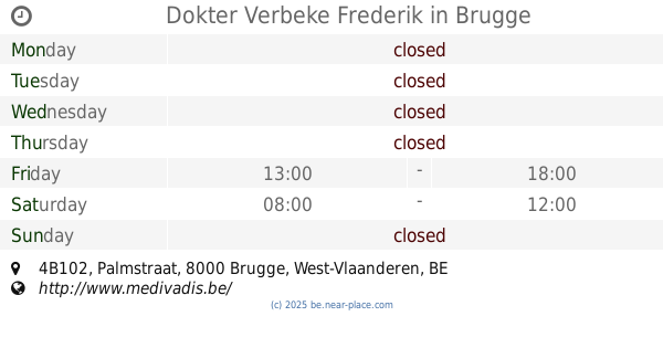
Dokter Verbeke Frederik (Brugge-Bruges)
Palmstraat 4B102, Brugge
Doctor
read more
1.094 km
Dokter Verbeke Frederik
Palmstraat 4B102, Brugge
Doctor
read more
1.158 km
Dr. Joachim Van Keirsbilck
Torhoutse Steenweg 257, Brugge
Doctor
read more
1.258 km
Simoens / Benedikt
Kuipersstraat 20, Brugge
Doctor
read more
📑
all categories
Accounting
Administrative area level 1
Administrative area level 2
Airport
Amusement park
Aquarium
Art gallery
Atm
Bakery
Bank
Bar
Beauty salon
Bicycle store
Book store
Bowling alley
Bus station
Cafe
Campground
Car dealer
Car rental
Car repair
Car wash
Casino
Cemetery
Church
City hall
Clothing store
Colloquial area
Convenience store
Country
Courthouse
Dentist
Department store
Doctor
Electrician
Electronics store
Embassy
Finance
Fire station
Florist
Food
Funeral home
Furniture store
Gas station
General contractor
Grocery or supermarket
Gym
Hair care
Hardware store
Health
Hindu Temple
Home goods store
Hospital
Insurance agency
Jewelry store
Laundry
Lawyer
Library
Light rail station
Liquor store
Local government office
Locality
Locksmith
Lodging
Meal delivery
Meal takeaway
Mosque
Movie rental
Movie theater
Moving company
Museum
Natural feature
Neighborhood
Night club
Painter
Park
Parking
Pet store
Pharmacy
Physiotherapist
Place of worship
Plumber
Point of interest
Police
Political
Post office
Premise
Real estate agency
Restaurant
Roofing contractor
Route
Rv park, camping
School
Shoe store
Shopping mall
Spa
Stadium
Storage
Store
Subpremise
Subway station
Supermarket
Synagogue
Taxi stand
Train station
Transit station
Travel agency
University
Veterinary care
Zoo
sublocality level 1
sublocality level 2
sublocality level 3
↑