City hall nearby Mairie - Mots'art
Belgium
City hall nearby Mairie - Mots'art
Mairie - Mots'art
43 Rue Jean de la Fontaine, Neuville-en-Ferrain Belgium
contacts phone
:
+32
Latitude:
50.7517633
, Longitude:
3.1576052
read more
nearest City hall
422 m
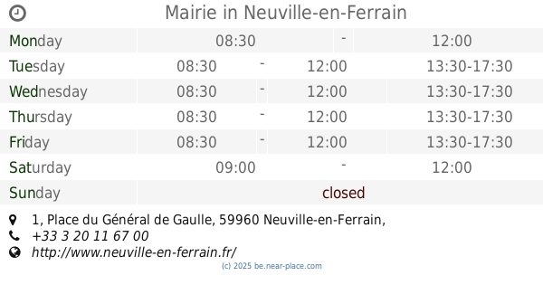
Mairie
1 Place du Général de Gaulle, Neuville-en-Ferrain
City hall
read more
444 m
Mairie - Animation
1 Rue Fernand Lecroart, Neuville-en-Ferrain
City hall
read more
1.426 km
Les P'tits Loups
118 Rue du Chemin Vert, Neuville-en-Ferrain
City hall
read more
1.889 km
Sce Dep de l'Education Nationale
8 Rue du Roitelet, Tourcoing
City hall
read more
2.152 km
Centre de Protection Maternelle et Infantile (PMI)
Place des Phalempins, Tourcoing
City hall
read more
2.267 km
Mairie (services municipaux)
13 Rue Monseigneur Leclerc, Tourcoing
City hall
read more
2.335 km
Mairie - stand de tir
17 Rue Claude Perrault, Tourcoing
City hall
read more
2.437 km
Mairie de Roncq
18 Rue du Docteur Galissot, Roncq
City hall
read more
2.444 km
Caisse Des Ecoles de Roncq
18 Rue du Docteur Galissot, Roncq
City hall
read more
2.738 km
Mairie
12 Rue Destombes, Roncq
City hall
read more
2.815 km
Mairie services municipaux
30 Avenue Jean Millet, Tourcoing
City hall
read more
2.823 km
Créche Aquarelle (Créche Mairie de Tourcoing)
30 Avenue Jean Millet, Tourcoing
City hall
read more
2.896 km
LCR la Pagode
47 Rue Joseph Hentgès, Tourcoing
City hall
read more
2.984 km
Mairie
7 Rue Gabriel Péri, Tourcoing
City hall
read more
3.02 km
Mairie
83 Rue de Tourcoing, Roncq
City hall
read more
3.099 km
City Hall Tourcoing
10 Place Victor Hassebroucq, Tourcoing
City hall
read more
3.286 km
Mairie
12 Rue Jules Watteeuw, Roncq
City hall
read more
3.367 km
Commune de Halluin
Avenue du Stade, Halluin
City hall
read more
3.711 km
Centre de PMI (Protection Maternelle et Infantile)
4 Ter Rue Arthur Dennetière, Halluin
City hall
read more
3.824 km
Mairie - service petite enfance
6 Rue Arthur Dennetière, Halluin
City hall
read more
4.041 km
Chamois Marie
Rue Gabriel Péri, Halluin
City hall
read more
4.082 km
VILLE DE MOUSCRON
Marktplein 1, Moeskroen
City hall
read more
4.271 km
Centre Administratif de Mouscron (CAM)
Rue de Courtrai 63, Mouscron
City hall
read more
4.899 km
Mairie (services municipaux)
359 Boulevard Gambetta, Tourcoing
City hall
read more
5.105 km
Cuisine Ecole Voltaire
Rue Voltaire, Wattrelos
City hall
read more
📑
all categories
Accounting
Administrative area level 1
Administrative area level 2
Airport
Amusement park
Aquarium
Art gallery
Atm
Bakery
Bank
Bar
Beauty salon
Bicycle store
Book store
Bowling alley
Bus station
Cafe
Campground
Car dealer
Car rental
Car repair
Car wash
Casino
Cemetery
Church
City hall
Clothing store
Colloquial area
Convenience store
Country
Courthouse
Dentist
Department store
Doctor
Electrician
Electronics store
Embassy
Finance
Fire station
Florist
Food
Funeral home
Furniture store
Gas station
General contractor
Grocery or supermarket
Gym
Hair care
Hardware store
Health
Hindu Temple
Home goods store
Hospital
Insurance agency
Jewelry store
Laundry
Lawyer
Library
Light rail station
Liquor store
Local government office
Locality
Locksmith
Lodging
Meal delivery
Meal takeaway
Mosque
Movie rental
Movie theater
Moving company
Museum
Natural feature
Neighborhood
Night club
Painter
Park
Parking
Pet store
Pharmacy
Physiotherapist
Place of worship
Plumber
Point of interest
Police
Political
Post office
Premise
Real estate agency
Restaurant
Roofing contractor
Route
Rv park, camping
School
Shoe store
Shopping mall
Spa
Stadium
Storage
Store
Subpremise
Subway station
Supermarket
Synagogue
Taxi stand
Train station
Transit station
Travel agency
University
Veterinary care
Zoo
sublocality level 1
sublocality level 2
sublocality level 3
↑