City hall nearby Mairie De Tourcoing ((Direction de l'Education))
Belgium
City hall nearby Mairie De Tourcoing ((Direction de l'Education))
Mairie De Tourcoing ((Direction de l'Education))
28 Rue Pierre de Guethem, Tourcoing Belgia
contacts phone
:
+32
Latitude:
50.7167667
, Longitude:
3.1606427
read more
nearest City hall
712 m
Mairie - Urbanisme
Place Victor Hassebroucq, Tourcoing
City hall
read more
801 m
City Hall Tourcoing
10 Place Victor Hassebroucq, Tourcoing
City hall
read more
834 m
La Station
16 Rue Paul Doumer, Tourcoing
City hall
read more
834 m
Mairie - Concertation, Vie de Quartier et Prévention
16 Rue Paul Doumer, Tourcoing
City hall
read more
888 m
Direction de l'Informatique et Télécommunications de la Mairie Tourcoing
3ème étage, 54, 54 Rue Gabriel Péri, Tourcoing
City hall
read more
899 m
Mairie
54 Rue Gabriel Péri, Tourcoing
City hall
read more
925 m
Mairie
7 Rue Gabriel Péri, Tourcoing
City hall
read more
1.006 km
Mairie (services municipaux)
359 Boulevard Gambetta, Tourcoing
City hall
read more
1.033 km
LCR la Pagode
47 Rue Joseph Hentgès, Tourcoing
City hall
read more
1.295 km
Créche Aquarelle (Créche Mairie de Tourcoing)
30 Avenue Jean Millet, Tourcoing
City hall
read more
1.297 km
Mairie services municipaux
30 Avenue Jean Millet, Tourcoing
City hall
read more
1.407 km
Mairie (services municipaux)
20 Rue du Viaduc, Tourcoing
City hall
read more
1.49 km
Dojo Jean Zay
Rue Alfred Delecourt, Wattrelos
City hall
read more
1.749 km
Centre de Protection Maternelle et Infantile (PMI)
Place des Phalempins, Tourcoing
City hall
read more
1.769 km
Serres Municipales
240 Quai de Marseille, Roubaix
City hall
read more
1.779 km
Maison pour Tous de la Mousserie
2 Rue Frédéric Chopin, Wattrelos
City hall
read more
1.846 km
Mairie
62 Rue Turgot, Roubaix
City hall
read more
1.877 km
Mairie
49 Rue de Cassel, Roubaix
City hall
read more
1.912 km
School Sacré Coeur Saint Paul
46 Rue Vauban, Mouvaux
City hall
read more
1.912 km
Ecole Sacré Coeur Saint Paul
46 Rue Vauban, Mouvaux
City hall
read more
1.956 km
Permanence Sociale
45 Rue de Cassel, Roubaix
City hall
read more
2.109 km
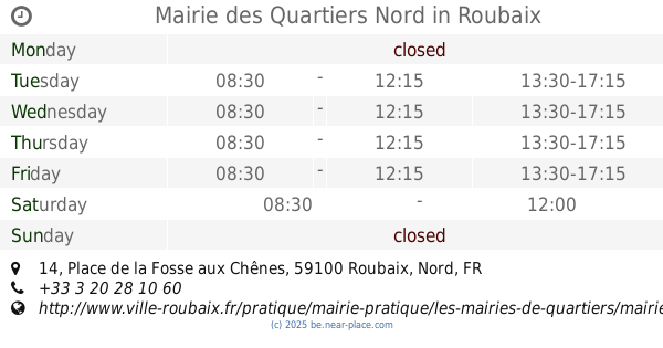
Mairie des Quartiers Nord
14 Place de la Fosse aux Chênes, Roubaix
City hall
read more
2.184 km
Mairie De Mouvaux
42 Boulevard Carnot, Mouvaux
City hall
read more
2.231 km
Mairie
46 Boulevard de Metz, Roubaix
City hall
read more
2.464 km
Cuisine Ecole Voltaire
Rue Voltaire, Wattrelos
City hall
read more
📑
all categories
Accounting
Administrative area level 1
Administrative area level 2
Airport
Amusement park
Aquarium
Art gallery
Atm
Bakery
Bank
Bar
Beauty salon
Bicycle store
Book store
Bowling alley
Bus station
Cafe
Campground
Car dealer
Car rental
Car repair
Car wash
Casino
Cemetery
Church
City hall
Clothing store
Colloquial area
Convenience store
Country
Courthouse
Dentist
Department store
Doctor
Electrician
Electronics store
Embassy
Finance
Fire station
Florist
Food
Funeral home
Furniture store
Gas station
General contractor
Grocery or supermarket
Gym
Hair care
Hardware store
Health
Hindu Temple
Home goods store
Hospital
Insurance agency
Jewelry store
Laundry
Lawyer
Library
Light rail station
Liquor store
Local government office
Locality
Locksmith
Lodging
Meal delivery
Meal takeaway
Mosque
Movie rental
Movie theater
Moving company
Museum
Natural feature
Neighborhood
Night club
Painter
Park
Parking
Pet store
Pharmacy
Physiotherapist
Place of worship
Plumber
Point of interest
Police
Political
Post office
Premise
Real estate agency
Restaurant
Roofing contractor
Route
Rv park, camping
School
Shoe store
Shopping mall
Spa
Stadium
Storage
Store
Subpremise
Subway station
Supermarket
Synagogue
Taxi stand
Train station
Transit station
Travel agency
University
Veterinary care
Zoo
sublocality level 1
sublocality level 2
sublocality level 3
↑