Church nearby Wever, Sint-Antoniuskerk
Belgium
Church nearby Wever, Sint-Antoniuskerk
Wever, Sint-Antoniuskerk
Solveldweg 2-8, Glabbeek België
contacts phone
:
+32
Latitude:
50.8578887
, Longitude:
4.9234202
read more
nearest Church
903 m
Kapel Heinkensberg
Heinkensbergstraat 2-4, Glabbeek
Church
read more
2.22 km
Sint-Quirinuskerk Bunsbeek
Bunsbeekdorp 4, Glabbeek
Church
read more
2.457 km
Sint-Niklaaskerk Glabbeek
Nieuwstraat 1-15, Glabbeek
Church
read more
3.72 km
Sint-Martinus
Boutersem
Church
read more
3.834 km
Sint-Catharinakerk Zuurbemde
Bronstraat 4, Glabbeek
Church
read more
4.528 km
Kerk Hoeleden
Kerkplein 1-5, Kortenaken
Church
read more
4.53 km
Sint-Amanduskerk Hoeleden
Kerkplein, Kortenaken
Church
read more
4.787 km
Heilige Anna
Boutersem
Church
read more
5.063 km
Sint-Anna
Boutersem
Church
read more
5.084 km
Sint-Gilliskerk
Tassinstraat, Tienen
Church
read more
5.177 km
St-Annakerk
Lubbeeksestraat 11, Boutersem
Church
read more
6.161 km
Heilige Jozef
Boutersem
Church
read more
9.695 km
Sint-Gorgoniuskerk
Houtmarkt, Hoegaarden
Church
read more
12.031 km
Sint-Lambertuskerk Nieuwrode
3220, Dorp 7, Nieuwrode
Church
read more
12.313 km
Bethaniakapel
Kruisveldstraat 1, Zoutleeuw
Church
read more
12.904 km
Kapel O.L.V. Van Bijstand.
Kortrijksestraat 335, Lubbeek
Church
read more
13.114 km
Kerk rillaar
4, Tieltseweg 2, Aarschot
Church
read more
13.39 km
Sint-Andreaskerk Loksbergen
Loksbergenstraat, Halen
Church
read more
13.643 km
Sint-Martinuskerk
Kerkstraat 30, Zoutleeuw
Church
read more
14.137 km
Pilgrimage Scherpenheuvel
Isabellaplein 1, Scherpenheuvel-Zichem
Church
read more
14.471 km
Sint-Jan Evangelistkerk
Leuven
Church
read more
14.637 km
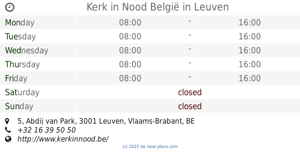
Kerk in Nood België
Abdij van Park 5, Leuven
Church
read more
15.427 km
Sint Pieters Banden.
Sint-Petrusstraat 17, Landen
Church
read more
17.162 km
Onze Lieve Vrouwe kerk
Bruidstraat 347, Diest
Church
read more
17.259 km
Sint-Laurentiuskerk
12,, Gelroodsesteenweg 4, Begijnendijk
Church
read more
📑
all categories
Accounting
Administrative area level 1
Administrative area level 2
Airport
Amusement park
Aquarium
Art gallery
Atm
Bakery
Bank
Bar
Beauty salon
Bicycle store
Book store
Bowling alley
Bus station
Cafe
Campground
Car dealer
Car rental
Car repair
Car wash
Casino
Cemetery
Church
City hall
Clothing store
Colloquial area
Convenience store
Country
Courthouse
Dentist
Department store
Doctor
Electrician
Electronics store
Embassy
Finance
Fire station
Florist
Food
Funeral home
Furniture store
Gas station
General contractor
Grocery or supermarket
Gym
Hair care
Hardware store
Health
Hindu Temple
Home goods store
Hospital
Insurance agency
Jewelry store
Laundry
Lawyer
Library
Light rail station
Liquor store
Local government office
Locality
Locksmith
Lodging
Meal delivery
Meal takeaway
Mosque
Movie rental
Movie theater
Moving company
Museum
Natural feature
Neighborhood
Night club
Painter
Park
Parking
Pet store
Pharmacy
Physiotherapist
Place of worship
Plumber
Point of interest
Police
Political
Post office
Premise
Real estate agency
Restaurant
Roofing contractor
Route
Rv park, camping
School
Shoe store
Shopping mall
Spa
Stadium
Storage
Store
Subpremise
Subway station
Supermarket
Synagogue
Taxi stand
Train station
Transit station
Travel agency
University
Veterinary care
Zoo
sublocality level 1
sublocality level 2
sublocality level 3
↑