Church nearby Kouterkapelletje
Belgium
Church nearby Kouterkapelletje
Kouterkapelletje
9700, Oudenaarde Belgium
contacts phone
:
+32
Latitude:
50.880371
, Longitude:
3.6603218
read more
nearest Church
369 m
Sint-Martinuskerk Welden
Monseigneur Lambrechtstraat, Oudenaarde
Church
read more
2.125 km
Heilige Rochuskapel
Biestmolenstraat 6-8, Zwalm
Church
read more
2.277 km
Sint-Amanduskerk Heurne
Heurnestraat, Oudenaarde
Church
read more
2.432 km
Sint-Vedastuskerk Nederename
Ohiostraat, Oudenaarde
Church
read more
2.658 km
Sint-Bavokerk
Kerkplein, Zingem
Church
read more
3.001 km
Sint-Elligiuskerk Eine
Eineplein, Oudenaarde
Church
read more
3.042 km
Onze-Lieve-Vrouwekapelletje
9700, Oudenaarde
Church
read more
3.461 km
Sint-Laurentiuskerk Ename
Paardemarktstraat, Oudenaarde
Church
read more
3.681 km
Sint-Martinuskerk Asper
Kerkwegel, Gavere
Church
read more
3.956 km
Heilig Hartkapel
Terweeenstraat 45-49, Zwalm
Church
read more
3.967 km
Sint-Denijs-Boekel Kerk
Vredesplein 36, Zwalm
Church
read more
4.137 km
Sint-Amelbergakapel
Oudenaarde
Church
read more
4.276 km
Kapel van de Vrede
9700, Oudenaarde
Church
read more
4.374 km
Sint-Hilariuskerk Mullem
Mullemstraat, Oudenaarde
Church
read more
4.645 km
Sint-Jozefkerk
Sint-Jozefsplein 8, Oudenaarde
Church
read more
4.73 km
Sint-Martinuskerk Volkegem
De La Kethulleplein, Oudenaarde
Church
read more
4.844 km
Sint-Margarethakapel
Wijlegem 2, Zwalm
Church
read more
4.844 km
Kapel van het Heilig Kruis
Rokegem 1-9, Horebeke
Church
read more
5.039 km
Kapel Onze-Lieve-Vrouw van Fatima
9700, Oudenaarde
Church
read more
5.123 km
Onze-Lieve-Vrouw-Hemelvaartkerk
Kerkplein 1, Horebeke
Church
read more
5.324 km
Sint-Pieterskerk Huise
Huiseplein 14, Zingem
Church
read more
5.701 km
Sint-Jan-Baptistkerk Ouwegem
Ouwegemsesteenweg 147, Zingem
Church
read more
5.766 km
O.L.V. Geboortekerk Pamele
Pamelekerkplein, Oudenaarde
Church
read more
5.766 km
Onze-Lieve-Vrouwekerk
Pamelekerkplein, Oudenaarde
Church
read more
5.836 km
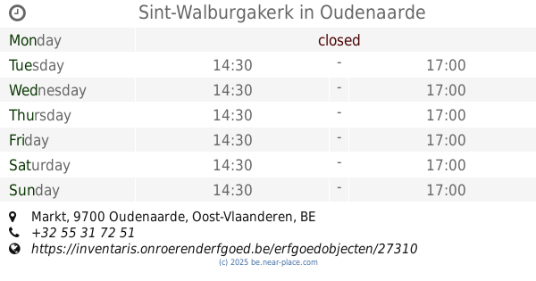
Sint-Walburgakerk
Markt, Oudenaarde
Church
read more
📑
all categories
Accounting
Administrative area level 1
Administrative area level 2
Airport
Amusement park
Aquarium
Art gallery
Atm
Bakery
Bank
Bar
Beauty salon
Bicycle store
Book store
Bowling alley
Bus station
Cafe
Campground
Car dealer
Car rental
Car repair
Car wash
Casino
Cemetery
Church
City hall
Clothing store
Colloquial area
Convenience store
Country
Courthouse
Dentist
Department store
Doctor
Electrician
Electronics store
Embassy
Finance
Fire station
Florist
Food
Funeral home
Furniture store
Gas station
General contractor
Grocery or supermarket
Gym
Hair care
Hardware store
Health
Hindu Temple
Home goods store
Hospital
Insurance agency
Jewelry store
Laundry
Lawyer
Library
Light rail station
Liquor store
Local government office
Locality
Locksmith
Lodging
Meal delivery
Meal takeaway
Mosque
Movie rental
Movie theater
Moving company
Museum
Natural feature
Neighborhood
Night club
Painter
Park
Parking
Pet store
Pharmacy
Physiotherapist
Place of worship
Plumber
Point of interest
Police
Political
Post office
Premise
Real estate agency
Restaurant
Roofing contractor
Route
Rv park, camping
School
Shoe store
Shopping mall
Spa
Stadium
Storage
Store
Subpremise
Subway station
Supermarket
Synagogue
Taxi stand
Train station
Transit station
Travel agency
University
Veterinary care
Zoo
sublocality level 1
sublocality level 2
sublocality level 3
↑