Church nearby Heilig-Hartkerk
Belgium
Church nearby Heilig-Hartkerk
Heilig-Hartkerk
Kemeldijk 18, Geel Belgien
contacts phone
:
+32
Latitude:
51.1277608
, Longitude:
5.0092208
read more
nearest Church
2.119 km
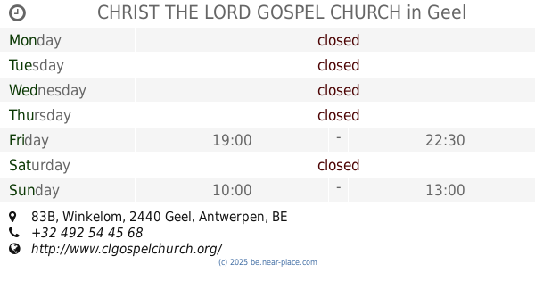
CHRIST THE LORD GOSPEL CHURCH
Winkelom 83B, Geel
Church
read more
2.251 km
Sint-Apoloniakerk Stelen
Geel
Church
read more
2.507 km
Sint-Lambertuskerk
Eindhoutdorp 3, Laakdal
Church
read more
3.173 km
Sint-Baafskerk Zittaart
Lindestraat 15, Meerhout
Church
read more
3.525 km
Kapel Onze-Lieve-Vrouw van Zeven Weeën
Ham 22, Laakdal
Church
read more
3.909 km
Sint-Dimpnakerk
Rijn 3-13, Geel
Church
read more
3.909 km
Église Sankt-Dipna
Rijn 3-13, Geel
Church
read more
4.033 km
St.-Amandskerk
Werft 13, Geel
Church
read more
4.839 km
Christelijk Centrum Levend Water vzw
Holven 19, Geel
Church
read more
4.884 km
Kerk
Sint-Trudoweg 3, Meerhout
Church
read more
5.308 km
Sint-Laurentiuskerk Zammel
Zammelseweg, Geel
Church
read more
5.436 km
Sint-Lambertuskerk Bel
Bel, Geel
Church
read more
5.876 km
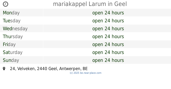
mariakappel Larum
Velveken 24, Geel
Church
read more
6.212 km
Larum kerk
2440, Geel
Church
read more
8.65 km
Rooms-Katholieke Kerk
Herselt,2230
Church
read more
9.783 km
St-Pieter en Pauwelkerk
Markt, Mol
Church
read more
9.884 km
Sint-Willibrorduskerk Olmen
Kerkplein, Balen
Church
read more
10.508 km
Kerk Sint-Niklaas Zoerle-Parwijs
Kerkstraat 16, Westerlo
Church
read more
12.097 km
Onze Lieve Vrouwe Geboorte Kerk
Heldenplein 19-23, Ham
Church
read more
13.156 km
Kerk Sint-Niklaas Morkhoven
Sint-Niklaasstraat, Herentals
Church
read more
13.342 km
Sint Jan De Doperkerk
Populierenlaan, Herentals
Church
read more
13.539 km
Sint-Jozefkapel
Bergstraat 2-10, Scherpenheuvel-Zichem
Church
read more
15.391 km
Sint-Lambertuskerk
Dorp1 3581, Beverlo
Church
read more
15.839 km
Sint-Theodarduskerk
Koolmijnlaan 348, Beringen
Church
read more
16.946 km
Sint-Adrianuskerk
J. Verlooyplein, Hulshout
Church
read more
📑
all categories
Accounting
Administrative area level 1
Administrative area level 2
Airport
Amusement park
Aquarium
Art gallery
Atm
Bakery
Bank
Bar
Beauty salon
Bicycle store
Book store
Bowling alley
Bus station
Cafe
Campground
Car dealer
Car rental
Car repair
Car wash
Casino
Cemetery
Church
City hall
Clothing store
Colloquial area
Convenience store
Country
Courthouse
Dentist
Department store
Doctor
Electrician
Electronics store
Embassy
Finance
Fire station
Florist
Food
Funeral home
Furniture store
Gas station
General contractor
Grocery or supermarket
Gym
Hair care
Hardware store
Health
Hindu Temple
Home goods store
Hospital
Insurance agency
Jewelry store
Laundry
Lawyer
Library
Light rail station
Liquor store
Local government office
Locality
Locksmith
Lodging
Meal delivery
Meal takeaway
Mosque
Movie rental
Movie theater
Moving company
Museum
Natural feature
Neighborhood
Night club
Painter
Park
Parking
Pet store
Pharmacy
Physiotherapist
Place of worship
Plumber
Point of interest
Police
Political
Post office
Premise
Real estate agency
Restaurant
Roofing contractor
Route
Rv park, camping
School
Shoe store
Shopping mall
Spa
Stadium
Storage
Store
Subpremise
Subway station
Supermarket
Synagogue
Taxi stand
Train station
Transit station
Travel agency
University
Veterinary care
Zoo
sublocality level 1
sublocality level 2
sublocality level 3
↑