Church nearby Goddelijk-Kind-Jezuskerk Turnhout
Belgium
Church nearby Goddelijk-Kind-Jezuskerk Turnhout
Goddelijk-Kind-Jezuskerk Turnhout
Steenweg op Oosthoven, Turnhout Belgium
contacts phone
:
+32
Latitude:
51.3311299
, Longitude:
4.9571743
read more
nearest Church
586 m
De Kerk van Jezus Christus van de Heiligen der Laatste Dagen
Koningin Elisabethlei 67, Turnhout
Church
read more
1.056 km
Sint-Pieterskerk
Grote Markt 80, Turnhout
Church
read more
1.07 km
Sint-Antoniuskerk
Otterstraat 126, Turnhout
Church
read more
1.164 km
Neogotische bidkapel
Herentalsstraat 6, Turnhout
Church
read more
1.263 km
The City of the Living God
Hendrik Consciencestraat 26, Turnhout
Church
read more
1.295 km
Koninkrijkszaal van Jehovah's getuigen Turnhout
Warandestraat 71, Turnhout
Church
read more
1.389 km
Nieuwe Creatie Turnhout
Herentalsstraat 70, Turnhout
Church
read more
1.503 km
Heilig Hartkerk
Kerkplein 9-17, Turnhout
Church
read more
1.525 km
Evangelisch centrum Turnhout
Guldensporenlei 27, Turnhout
Church
read more
1.56 km
Roemeens Evangelisch Centrum Turnhout (Biserica Maranata Turnhout)
Stationstraat 42/44, Turnhout
Church
read more
2.095 km
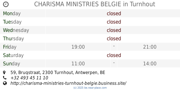
CHARISMA MINISTRIES BELGIE
Brugstraat 59, Turnhout
Church
read more
2.124 km
Onze-Lieve-Vrouw Middelareskerk
De Merodelei 193, Turnhout
Church
read more
2.181 km
Sint bavo
Draaiboom 11, Oud-Turnhout
Church
read more
2.495 km
Kerk Sint-Franciscus
Turnhout
Church
read more
2.533 km
Wonen Stadsregio Turnhout
Campus Blairon 200, Turnhout
Church
read more
2.621 km
Pinksterkerk
Collegestraat 26, Turnhout
Church
read more
2.686 km
OLV van Troost
2300, Turnhout
Church
read more
3.083 km
Protestant Church of Turnhout (EPUB)
Steenweg op Gierle 188, Turnhout
Church
read more
3.083 km
Protestantse Kerk van Turnhout (VPKB)
Steenweg op Gierle 188, Turnhout
Church
read more
4.943 km
O.L. vrouwekerk zevendonk
Glazeniersstraat 1, Turnhout
Church
read more
7.096 km
Apostolische Gemeente De Rots
Gasthuisstraat 36, Beerse
Church
read more
9.468 km
Onze-Lieve-Vrouwekerk Gierle
Singel 2-4, Lille
Church
read more
11.361 km
Sint-Martinuskerk Retie
Markt, Retie
Church
read more
14.977 km
Kapelletje van Hal
Hal 40, Hoogstraten
Church
read more
16.081 km
Millennium Kapel OLV ter Doncken
Groeske 5, Castelre
Church
read more
📑
all categories
Accounting
Administrative area level 1
Administrative area level 2
Airport
Amusement park
Aquarium
Art gallery
Atm
Bakery
Bank
Bar
Beauty salon
Bicycle store
Book store
Bowling alley
Bus station
Cafe
Campground
Car dealer
Car rental
Car repair
Car wash
Casino
Cemetery
Church
City hall
Clothing store
Colloquial area
Convenience store
Country
Courthouse
Dentist
Department store
Doctor
Electrician
Electronics store
Embassy
Finance
Fire station
Florist
Food
Funeral home
Furniture store
Gas station
General contractor
Grocery or supermarket
Gym
Hair care
Hardware store
Health
Hindu Temple
Home goods store
Hospital
Insurance agency
Jewelry store
Laundry
Lawyer
Library
Light rail station
Liquor store
Local government office
Locality
Locksmith
Lodging
Meal delivery
Meal takeaway
Mosque
Movie rental
Movie theater
Moving company
Museum
Natural feature
Neighborhood
Night club
Painter
Park
Parking
Pet store
Pharmacy
Physiotherapist
Place of worship
Plumber
Point of interest
Police
Political
Post office
Premise
Real estate agency
Restaurant
Roofing contractor
Route
Rv park, camping
School
Shoe store
Shopping mall
Spa
Stadium
Storage
Store
Subpremise
Subway station
Supermarket
Synagogue
Taxi stand
Train station
Transit station
Travel agency
University
Veterinary care
Zoo
sublocality level 1
sublocality level 2
sublocality level 3
↑