Cemetery nearby Kerkhof van Zeveren
Belgium
Cemetery nearby Kerkhof van Zeveren
Kerkhof van Zeveren
Kerkstraat, Deinze Belgien
contacts phone
:
+32
Latitude:
50.9961937
, Longitude:
3.5033873
read more
nearest Cemetery
1.979 km
Kerkhof van Deinze
Peter Benoitlaan, Deinze
Cemetery
read more
2.015 km
Kerkhof van Vinkt
Martelarenplein, Deinze
Cemetery
read more
2.932 km
Kerkhof van Petegem-aan-de-Leie
Sint-Hubertstraat, Deinze
Cemetery
read more
3.091 km
Kerkhof van Grammene
Sint-Jansstraat, Deinze
Cemetery
read more
3.484 km
Kerkhof van Meigem
Berg, Deinze
Cemetery
read more
4.105 km
Kerkhof van Astene
Parijssestraat, Parijsestraat, Deinze
Cemetery
read more
4.108 km
Begraafplaats Astene
Deinze
Cemetery
read more
4.261 km
Wontergem Begraafplats
Deinze
Cemetery
read more
4.27 km
Kerkhof van Wontergem
Houtbulckstraat, Houtbulkstraat, Deinze
Cemetery
read more
4.271 km
Kerkhof van Machelen
Karperstraat, Zulte
Cemetery
read more
4.283 km
Kerkhof Poesele
Poeseledorp, Nevele
Cemetery
read more
4.303 km
Begraafplaats 14-18
Zulte
Cemetery
read more
4.317 km
Franse militaire begraafplaats
Zulte
Cemetery
read more
4.486 km
Kerkhof van Gottem
Ardense Jagersstraat-Gottem, Deinze
Cemetery
read more
4.789 km
Kerkhof van Machelen (nieuw)
Veerstraat, Zulte
Cemetery
read more
4.92 km
Kerkhof Vosselare
Vosselaredorp, Nevele
Cemetery
read more
4.971 km
Natuursteen Brachot Hermant nv
E3-laan 86, Deinze
Cemetery
read more
5.54 km
Kerkhof Nevele
Vaartrechtstraat, Nevele
Cemetery
read more
8.866 km
Kerkhof van Zulte
Oeselgemstraat, Zulte
Cemetery
read more
9.974 km
Kerkhof van Sint-Martens-Latem
Mortelputstraat, Sint-Martens-Latem
Cemetery
read more
12.932 km
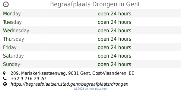
Begraafplaats Drongen
Mariakerksesteenweg 209, Gent
Cemetery
read more
14.23 km
Center cemetery
Kalbergstraat, Oostrozebeke
Cemetery
read more
15.343 km
Kerkhof Ronsele
Kerkplein, Zomergem
Cemetery
read more
18.202 km
Beveren Leie Communal Cemetery
Sint-Jansstraat 126-128, Waregem
Cemetery
read more
19.094 km
Begraafplaats Hulste
Tieltsestraat, Harelbeke
Cemetery
read more
📑
all categories
Accounting
Administrative area level 1
Administrative area level 2
Airport
Amusement park
Aquarium
Art gallery
Atm
Bakery
Bank
Bar
Beauty salon
Bicycle store
Book store
Bowling alley
Bus station
Cafe
Campground
Car dealer
Car rental
Car repair
Car wash
Casino
Cemetery
Church
City hall
Clothing store
Colloquial area
Convenience store
Country
Courthouse
Dentist
Department store
Doctor
Electrician
Electronics store
Embassy
Finance
Fire station
Florist
Food
Funeral home
Furniture store
Gas station
General contractor
Grocery or supermarket
Gym
Hair care
Hardware store
Health
Hindu Temple
Home goods store
Hospital
Insurance agency
Jewelry store
Laundry
Lawyer
Library
Light rail station
Liquor store
Local government office
Locality
Locksmith
Lodging
Meal delivery
Meal takeaway
Mosque
Movie rental
Movie theater
Moving company
Museum
Natural feature
Neighborhood
Night club
Painter
Park
Parking
Pet store
Pharmacy
Physiotherapist
Place of worship
Plumber
Point of interest
Police
Political
Post office
Premise
Real estate agency
Restaurant
Roofing contractor
Route
Rv park, camping
School
Shoe store
Shopping mall
Spa
Stadium
Storage
Store
Subpremise
Subway station
Supermarket
Synagogue
Taxi stand
Train station
Transit station
Travel agency
University
Veterinary care
Zoo
sublocality level 1
sublocality level 2
sublocality level 3
↑