Cafe nearby Val Fleuri
Belgium
Cafe nearby Val Fleuri
Val Fleuri
Rue L Vanmeerbeek 116, Grez-Doiceau Belgium
contacts phone
:
+32
Latitude:
50.7615027
, Longitude:
4.6534794
read more
nearest Cafe
2.837 km
Café De Welkom
Leuvensebaan 67, Huldenberg
Cafe
read more
2.872 km
Het Zevende Zegel
Leuvensebaan 66, Ottenburg
Cafe
read more
3.097 km
De Plataan - Axismundi
Leuvensebaan 362, Huldenberg
Cafe
read more
3.603 km
Café Isba
Leuvensestraat 3, Overijse
Cafe
read more
4.59 km
Cafe In De Rapte
Beekstraat 9, Oud-Heverlee
Cafe
read more
5.003 km
Maca Fétéria
Avenue du Centre Sportif, Wavre
Cafe
read more
5.784 km
Namurois (Le)
25, Place Cardinal Mercier, Wavre
Cafe
read more
5.813 km
Vanderveken / Herman
Gemeenteplein 23, Huldenberg
Cafe
read more
5.939 km
't Gouvernement
De Peuthystraat 10, Huldenberg
Cafe
read more
8.394 km
Johan
Stationsstraat 38, Overijse
Cafe
read more
9.216 km
Michiels-Buggenhout / Sonja
Waversebaan 72, Oud-Heverlee
Cafe
read more
10.078 km
bouquet de thé
Place de la Gare 5, Rixensart
Cafe
read more
10.666 km
Gaudeamus Igitur
Rue des Wallons 64, Ottignies-Louvain-la-Neuve
Cafe
read more
10.816 km
Miam2
Rue des Ateliers 18, Rixensart
Cafe
read more
12.984 km
Cafe Groenveld
Groenveldstraat 2, Leuven
Cafe
read more
13.07 km
Gasthuisberg coffeeshop
Herestraat 49, Leuven
Cafe
read more
13.359 km
Politika Kaffee
Tiensestraat 55, Leuven
Cafe
read more
13.43 km
Cafe De Steenberg
Tervuren
Cafe
read more
13.491 km
Mon Martre
Parijsstraat 6, Leuven
Cafe
read more
13.549 km
Zonnekompas
Brusselsestraat 146, Leuven
Cafe
read more
13.661 km
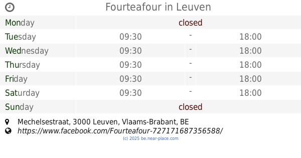
Fourteafour
Mechelsestraat, Leuven
Cafe
read more
13.725 km
Optimist
Vismarkt 7, Leuven
Cafe
read more
13.909 km
MOK Specialty Coffee Roastery & Bar
Diestsestraat 165, Leuven
Cafe
read more
15.115 km
Pinxtermolen
Diestsesteenweg 480, Leuven
Cafe
read more
16.679 km
De Tinnen Pot - Decock Marc
Mechelsesteenweg 488, Nossegem
Cafe
read more
📑
all categories
Accounting
Administrative area level 1
Administrative area level 2
Airport
Amusement park
Aquarium
Art gallery
Atm
Bakery
Bank
Bar
Beauty salon
Bicycle store
Book store
Bowling alley
Bus station
Cafe
Campground
Car dealer
Car rental
Car repair
Car wash
Casino
Cemetery
Church
City hall
Clothing store
Colloquial area
Convenience store
Country
Courthouse
Dentist
Department store
Doctor
Electrician
Electronics store
Embassy
Finance
Fire station
Florist
Food
Funeral home
Furniture store
Gas station
General contractor
Grocery or supermarket
Gym
Hair care
Hardware store
Health
Hindu Temple
Home goods store
Hospital
Insurance agency
Jewelry store
Laundry
Lawyer
Library
Light rail station
Liquor store
Local government office
Locality
Locksmith
Lodging
Meal delivery
Meal takeaway
Mosque
Movie rental
Movie theater
Moving company
Museum
Natural feature
Neighborhood
Night club
Painter
Park
Parking
Pet store
Pharmacy
Physiotherapist
Place of worship
Plumber
Point of interest
Police
Political
Post office
Premise
Real estate agency
Restaurant
Roofing contractor
Route
Rv park, camping
School
Shoe store
Shopping mall
Spa
Stadium
Storage
Store
Subpremise
Subway station
Supermarket
Synagogue
Taxi stand
Train station
Transit station
Travel agency
University
Veterinary care
Zoo
sublocality level 1
sublocality level 2
sublocality level 3
↑