Cafe nearby Tom Dooley
Belgium
Cafe nearby Tom Dooley
Tom Dooley
Jan de Coomanstraat 5, Geraardsbergen Belgium
contacts phone
:
+32
Latitude:
50.8042405
, Longitude:
3.9636749
read more
nearest Cafe
1.261 km
cafe jempi
't, Het Angereelstraat 99
Cafe
read more
1.407 km
Eldorado
Lindeveldstraat 30, Geraardsbergen
Cafe
read more
1.448 km
Van Laethem / Nestor
Hellestraat 108, Ninove
Cafe
read more
1.474 km
Breugel
Hellestraat 84, Ninove
Cafe
read more
2.545 km
Don Gilberto
Zijpstraat, Geraardsbergen
Cafe
read more
2.64 km
't Lusthof
Krepelstraat 166, Ninove
Cafe
read more
2.643 km
Taverne t'Gemeentehuis
Idegemplein 8, Geraardsbergen
Cafe
read more
2.66 km
Zwarte Flesch
Schuitstraat 17, Ninove
Cafe
read more
2.903 km
Café Viviane
Wallestraat 16, Geraardsbergen
Cafe
read more
3.178 km
Cofee Blacky
Perrestraat 16, Ninove
Cafe
read more
3.187 km
Blacky Coffees
Lindenbergstraat 21, Ninove
Cafe
read more
3.409 km
Diensten-Atelier / Strijkwinkel
Roe 17, Pollare
Cafe
read more
3.494 km
't Buitenbeentje
Vuilstraat 5, Geraardsbergen
Cafe
read more
4.144 km
Café Voetballokaal
Edingsesteenweg 303, Ninove
Cafe
read more
4.348 km
Voetbalkantine Aspelare
Geraardsbergsesteenweg 279, Ninove
Cafe
read more
4.353 km
Prieels / Elie
Geraardsbergsesteenweg 279, Ninove
Cafe
read more
4.626 km
Café 't Perron
Moenebroekstraat 12, Geraardsbergen
Cafe
read more
4.645 km
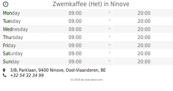
Zwemkaffee (Het)
Parklaan 3/B, Ninove
Cafe
read more
5.045 km
Kosynski / Adriana
Burchtdam 102, Ninove
Cafe
read more
5.051 km
De Rop Guy
Brusselstraat 34, Ninove
Cafe
read more
5.2 km
De Rio
Brusselsesteenweg 19, Ninove
Cafe
read more
5.237 km
Bistrot Carte Blanche
Kaardeloodstraat 97, Ninove
Cafe
read more
5.494 km
Sint-Annakamer
Biezenstraat 20, Ninove
Cafe
read more
5.667 km
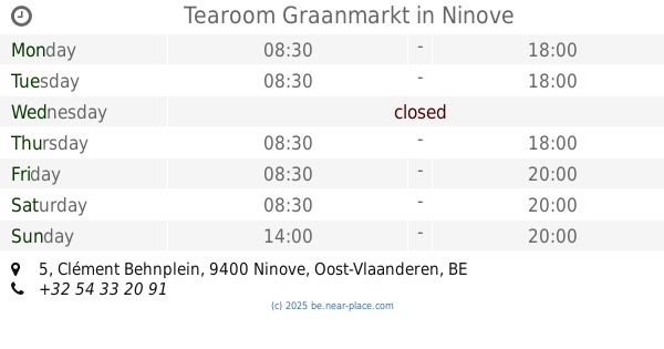
Tearoom Graanmarkt
Clément Behnplein 5, Ninove
Cafe
read more
6.029 km
Café De Groeneweg
Aalstersesteenweg 75, Ninove
Cafe
read more
📑
all categories
Accounting
Administrative area level 1
Administrative area level 2
Airport
Amusement park
Aquarium
Art gallery
Atm
Bakery
Bank
Bar
Beauty salon
Bicycle store
Book store
Bowling alley
Bus station
Cafe
Campground
Car dealer
Car rental
Car repair
Car wash
Casino
Cemetery
Church
City hall
Clothing store
Colloquial area
Convenience store
Country
Courthouse
Dentist
Department store
Doctor
Electrician
Electronics store
Embassy
Finance
Fire station
Florist
Food
Funeral home
Furniture store
Gas station
General contractor
Grocery or supermarket
Gym
Hair care
Hardware store
Health
Hindu Temple
Home goods store
Hospital
Insurance agency
Jewelry store
Laundry
Lawyer
Library
Light rail station
Liquor store
Local government office
Locality
Locksmith
Lodging
Meal delivery
Meal takeaway
Mosque
Movie rental
Movie theater
Moving company
Museum
Natural feature
Neighborhood
Night club
Painter
Park
Parking
Pet store
Pharmacy
Physiotherapist
Place of worship
Plumber
Point of interest
Police
Political
Post office
Premise
Real estate agency
Restaurant
Roofing contractor
Route
Rv park, camping
School
Shoe store
Shopping mall
Spa
Stadium
Storage
Store
Subpremise
Subway station
Supermarket
Synagogue
Taxi stand
Train station
Transit station
Travel agency
University
Veterinary care
Zoo
sublocality level 1
sublocality level 2
sublocality level 3
↑