Cafe nearby Stadcafé Feesthal De Kring
Belgium
Cafe nearby Stadcafé Feesthal De Kring
Stadcafé Feesthal De Kring
A. Sauwenlaan 90, Dilsen-Stokkem België
contacts phone
:
+32
Latitude:
51.0200893
, Longitude:
5.7420412
read more
nearest Cafe
113 m
The Stone Pit
Steenkuilstraat 21, Dilsen-Stokkem
Cafe
read more
280 m
Steegmans-Biesmans / Jacobus
Rechtestraat 17/A, Dilsen-Stokkem
Cafe
read more
407 m
Zaal Astrid
Maasstraat 2-6, Dilsen-Stokkem
Cafe
read more
407 m
Astrid hall
Maasstraat 2-6, Dilsen-Stokkem
Cafe
read more
1.41 km
Dubois / Jacqueline
Dorpsstraat 57/A, Dilsen-Stokkem
Cafe
read more
1.655 km
Conings / Jean-Pierre
Oude Baan 64, Dilsen-Stokkem
Cafe
read more
1.758 km
het moment
Litzberg 35, Dilsen-Stokkem
Cafe
read more
1.981 km
In den Arend
Rijksweg 461, Dilsen-Stokkem
Cafe
read more
2.261 km
Jeugdhuis De Barak
Vlessersweg 15, Dilsen-Stokkem
Cafe
read more
2.444 km
Café "Lombok"
Bergerstraat 51, Urmond
Cafe
read more
2.444 km
Café Biljart
Europalaan 80, Dilsen-Stokkem
Cafe
read more
2.524 km
Café Demandt
Berger Maasstraat 10, Urmond
Cafe
read more
2.71 km
Hotel Knoors-Meeks
Steenweg 2, Urmond
Cafe
read more
2.944 km
Café "De Koosjtal"
Koestraat 28, Obbicht
Cafe
read more
3.133 km
Mea Cuppa, Boulangerie
Zetellaan 100, Maasmechelen
Cafe
read more
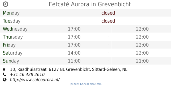
3.15 km
Eetcafé Aurora
Raadhuisstraat 10, Grevenbicht
Cafe
read more
3.179 km
Café De Mert
Raadhuisstraat 2-A, Grevenbicht
Cafe
read more
3.189 km
Stichting Beheer Aurora Beeg
Rozenlaan 9, Grevenbicht
Cafe
read more
3.555 km
Brasserie Village
Zetellaan 1023/A, Maasmechelen
Cafe
read more
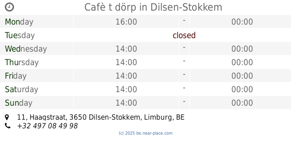
3.567 km
Cafè t dörp
Haagstraat 11, Dilsen-Stokkem
Cafe
read more
3.595 km
Café zaal 't Törp
Staai 20, Grevenbicht
Cafe
read more
3.653 km
Cafe Potbelly
Julianalaan 5, Papenhoven
Cafe
read more
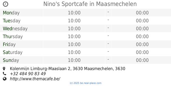
3.862 km
Nino's Sportcafe
Kolenmijn Limburg-Maaslaan 2, 3630 Maasmechelen, Maasmechelen
Cafe
read more
4.085 km
Daniëls / Alain
Koninginnelaan 4, Maasmechelen
Cafe
read more
5.234 km
Café De Bar
Dorpstraat 92, Buchten
Cafe
read more
📑
all categories
Accounting
Administrative area level 1
Administrative area level 2
Airport
Amusement park
Aquarium
Art gallery
Atm
Bakery
Bank
Bar
Beauty salon
Bicycle store
Book store
Bowling alley
Bus station
Cafe
Campground
Car dealer
Car rental
Car repair
Car wash
Casino
Cemetery
Church
City hall
Clothing store
Colloquial area
Convenience store
Country
Courthouse
Dentist
Department store
Doctor
Electrician
Electronics store
Embassy
Finance
Fire station
Florist
Food
Funeral home
Furniture store
Gas station
General contractor
Grocery or supermarket
Gym
Hair care
Hardware store
Health
Hindu Temple
Home goods store
Hospital
Insurance agency
Jewelry store
Laundry
Lawyer
Library
Light rail station
Liquor store
Local government office
Locality
Locksmith
Lodging
Meal delivery
Meal takeaway
Mosque
Movie rental
Movie theater
Moving company
Museum
Natural feature
Neighborhood
Night club
Painter
Park
Parking
Pet store
Pharmacy
Physiotherapist
Place of worship
Plumber
Point of interest
Police
Political
Post office
Premise
Real estate agency
Restaurant
Roofing contractor
Route
Rv park, camping
School
Shoe store
Shopping mall
Spa
Stadium
Storage
Store
Subpremise
Subway station
Supermarket
Synagogue
Taxi stand
Train station
Transit station
Travel agency
University
Veterinary care
Zoo
sublocality level 1
sublocality level 2
sublocality level 3
↑