Cafe nearby Snack Stalingrad
Belgium
Cafe nearby Snack Stalingrad
Snack Stalingrad
113, Avenue de Stalingrad, 1000, Bruxelles, BE Belgia
contacts phone
:
+32
Latitude:
50.8396886
, Longitude:
4.3413976
larger map & directions
read more
nearest Cafe
245 m
Brasserie Athoise
Zuidlaan 90, Brussel
Cafe
read more
388 m
Douro
Ruslandstraat 20, Sint-Gillis
Cafe
read more
423 m
Santana Cafe
Place Rouppe 24, Bruxelles
Cafe
read more
556 m
Het Warm Water
Vossenstraat 25, Brussel
Cafe
read more
577 m
Caféabc (EAT vzw)
Rue Philippe de Champagne 23, Bruxelles
Cafe
read more
812 m
CAFE MONTREAL
Boulevard de la Révision 1070, Anderlecht
Cafe
read more
829 m
Potemkine
Hallepoortlaan 2, Sint-Gillis
Cafe
read more
889 m
La Licorne
Vorstse Steenweg 59, Sint-Gillis
Cafe
read more
930 m
La Maison du Thé
Plattesteen 11, Brussel
Cafe
read more
934 m
Chez Houcine
Place du Jardin aux Fleurs 14, Bruxelles
Cafe
read more
957 m
Marcel Bike Café
Georges Matheusstraat 43, Sint-Joost-ten-Node
Cafe
read more
958 m
Charif
Anspachlaan 105, Brussel
Cafe
read more
960 m
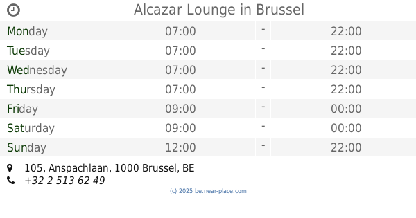
Alcazar Lounge
Anspachlaan 105, Brussel
Cafe
read more
987 m
Snack halal
Zuidstraat 44, Brussel
Cafe
read more
995 m
Acrobat
Borgval 14, Brussel
Cafe
read more
1.01 km
l'atelier du sandwich
Gerechtsplein 23, Brussel
Cafe
read more
1.035 km
€1 Waffle
Rue Charles Buls 2, Bruxelles
Cafe
read more
1.049 km
Verreckt / Eugene
Rue Du Bateau 40, Molenbeek-Saint-Jean
Cafe
read more
1.061 km
Pp Cafe
Rue Jules Van Praet 28, Bruxelles
Cafe
read more
1.168 km
St. Nicolas
Korte Boterstraat 8, Brussel
Cafe
read more
1.179 km
Aux Gaufres De Bruxelles
Grasmarkt Straat 113, Brussel
Cafe
read more
1.196 km
Juice Land
Rue du Marché aux Herbes 11, Bruxelles
Cafe
read more
1.203 km
Kaffee Brussel Downtown
Kiekenmarkt 46-48, Brussel
Cafe
read more
1.294 km
Neuhaus - Salon de chocolat
Galerie de la Reine 29, Bruxelles
Cafe
read more
1.346 km
Méert - Bruxelles, Galerie du Roi
7 Galerie du Roi
Cafe
read more
📑
all categories
Accounting
Administrative area level 1
Administrative area level 2
Airport
Amusement park
Aquarium
Art gallery
Atm
Bakery
Bank
Bar
Beauty salon
Bicycle store
Book store
Bowling alley
Bus station
Cafe
Campground
Car dealer
Car rental
Car repair
Car wash
Casino
Cemetery
Church
City hall
Clothing store
Colloquial area
Convenience store
Country
Courthouse
Dentist
Department store
Doctor
Electrician
Electronics store
Embassy
Finance
Fire station
Florist
Food
Funeral home
Furniture store
Gas station
General contractor
Grocery or supermarket
Gym
Hair care
Hardware store
Health
Hindu Temple
Home goods store
Hospital
Insurance agency
Jewelry store
Laundry
Lawyer
Library
Light rail station
Liquor store
Local government office
Locality
Locksmith
Lodging
Meal delivery
Meal takeaway
Mosque
Movie rental
Movie theater
Moving company
Museum
Natural feature
Neighborhood
Night club
Painter
Park
Parking
Pet store
Pharmacy
Physiotherapist
Place of worship
Plumber
Point of interest
Police
Political
Post office
Premise
Real estate agency
Restaurant
Roofing contractor
Route
Rv park, camping
School
Shoe store
Shopping mall
Spa
Stadium
Storage
Store
Subpremise
Subway station
Supermarket
Synagogue
Taxi stand
Train station
Transit station
Travel agency
University
Veterinary care
Zoo
sublocality level 1
sublocality level 2
sublocality level 3
↑