Cafe nearby Oad Grathem
Belgium
Cafe nearby Oad Grathem
Oad Grathem
Schoolstraat 18, Grathem Belgium
contacts phone
:
+32
Latitude:
51.1924577
, Longitude:
5.856936
read more
nearest Cafe
1.841 km
Taverne Christel
Oude Thornerweg 18, Heel
Cafe
read more
1.884 km
Beach Club
Thornerweg 9, Heel
Cafe
read more
1.944 km
Meijca
Zavelveldweg 4, Heel
Cafe
read more
2.767 km
't Kapelhuis
Heerbaan-Kapel 2, Thorn
Cafe
read more
3.008 km
Café de Tram
Heerbaan 55, Heel
Cafe
read more
3.048 km
Buisman Place
Irisstraat 17, Ittervoort
Cafe
read more
3.172 km
Café D'n Ingel
Schoolstraat 20, Thorn
Cafe
read more
3.174 km
cafezaal D'n Ingel
Schoolstraat 20, Thorn
Cafe
read more
3.174 km
't Stuupke
Dorpsstraat 59, Heel
Cafe
read more
3.212 km
Spaarkasvereniging Café de Tram
Julianastraat 3, Heel
Cafe
read more
3.401 km
Café De Pegel
Eind 5, Thorn
Cafe
read more
3.465 km
V.O.F. Aod Thoear
Steegputstraat 4, Thorn
Cafe
read more
3.635 km
Bruin cafe De Zonnewyzer
Hoogstraat 18, Thorn
Cafe
read more
3.849 km
Café Den Hook
Van Horneplein 9, Wessem
Cafe
read more
3.881 km
Café Zaal De Harmonie
Wallenstraat 7, Wessem
Cafe
read more
4.328 km
Café "'t Jachthuis"
Abelenstraat 4, Beegden
Cafe
read more
4.35 km
Pur Sang Beheer B.V.
Waage Naak 38, Wessem
Cafe
read more
4.788 km
Café-Friture de Heerlijckheid
Lambertusstraat 50, Neeritter
Cafe
read more
5.046 km
V.O.F. Scheepers-Hansen
Bosstraat 10, Neeritter
Cafe
read more
5.263 km
Zaal De Kősterie
AJ, Hoofdstraat 34, Maasbracht
Cafe
read more
5.395 km
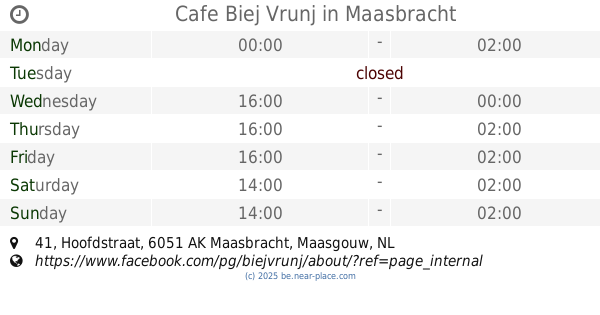
Cafe Biej Vrunj
Hoofdstraat 41, Maasbracht
Cafe
read more
5.444 km
Jaggerz Coffee and sandwich bar
Molenweg 10, Maasbracht
Cafe
read more
5.449 km
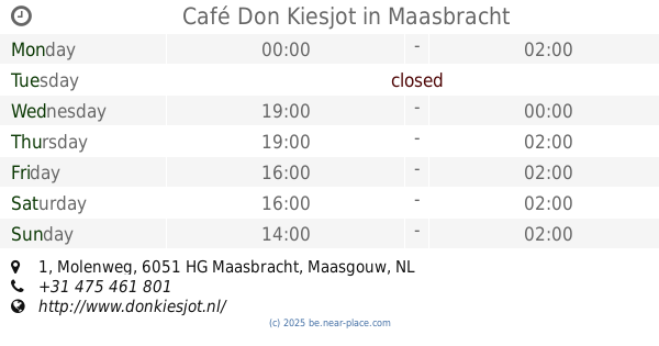
Café Don Kiesjot
Molenweg 1, Maasbracht
Cafe
read more
5.45 km
V.O.F. Café Don Kiesjot
Molenweg 1f, Maasbracht
Cafe
read more
5.983 km
Cafe De Knup
Breeërsteenweg 11-21, Kinrooi
Cafe
read more
📑
all categories
Accounting
Administrative area level 1
Administrative area level 2
Airport
Amusement park
Aquarium
Art gallery
Atm
Bakery
Bank
Bar
Beauty salon
Bicycle store
Book store
Bowling alley
Bus station
Cafe
Campground
Car dealer
Car rental
Car repair
Car wash
Casino
Cemetery
Church
City hall
Clothing store
Colloquial area
Convenience store
Country
Courthouse
Dentist
Department store
Doctor
Electrician
Electronics store
Embassy
Finance
Fire station
Florist
Food
Funeral home
Furniture store
Gas station
General contractor
Grocery or supermarket
Gym
Hair care
Hardware store
Health
Hindu Temple
Home goods store
Hospital
Insurance agency
Jewelry store
Laundry
Lawyer
Library
Light rail station
Liquor store
Local government office
Locality
Locksmith
Lodging
Meal delivery
Meal takeaway
Mosque
Movie rental
Movie theater
Moving company
Museum
Natural feature
Neighborhood
Night club
Painter
Park
Parking
Pet store
Pharmacy
Physiotherapist
Place of worship
Plumber
Point of interest
Police
Political
Post office
Premise
Real estate agency
Restaurant
Roofing contractor
Route
Rv park, camping
School
Shoe store
Shopping mall
Spa
Stadium
Storage
Store
Subpremise
Subway station
Supermarket
Synagogue
Taxi stand
Train station
Transit station
Travel agency
University
Veterinary care
Zoo
sublocality level 1
sublocality level 2
sublocality level 3
↑