Cafe nearby Jeugdhuis Tuitvlugt Vzw
Belgium
Cafe nearby Jeugdhuis Tuitvlugt Vzw
Jeugdhuis Tuitvlugt Vzw
Frans Beirenslaan 2a, Borsbeek Belgium
contacts phone
:
+32
Latitude:
51.1889646
, Longitude:
4.4797558
read more
nearest Cafe
672 m
Cafe Classics
de Robianostraat 100, Borsbeek
Cafe
read more
716 m
Yayla
de Robianostraat 48, Borsbeek
Cafe
read more
756 m
Poney Pub
de Robianostraat 181, Borsbeek
Cafe
read more
1.025 km
Cafee Het Sport
Jozef Reusenslei 89, Borsbeek
Cafe
read more
1.276 km
Depuydt / Caroline
Unitaslaan 84, Antwerpen
Cafe
read more
1.478 km
@ The Park
Unitaslaan 84, (ingang Boekenbergpark), Antwerpen
Cafe
read more
1.478 km
@ The Park - Boekenbergpark
Unitaslaan 84, (ingang Boekenbergpark), Antwerpen
Cafe
read more
1.51 km
Cavazzon / Suzanne
Herentalsebaan 83, Borsbeek
Cafe
read more
1.688 km
Café Exter
Eksterlaar 3, Antwerpen
Cafe
read more
1.824 km
't Koffiemieke
Cruyslei 73, Antwerpen
Cafe
read more
1.952 km
Djo's cafe
Muggenberglei 274, Antwerpen
Cafe
read more
2.003 km
Café Monica
Florent Pauwelslei 6, Antwerpen
Cafe
read more
2.024 km
Cambrinus
Gitschotellei 377, Borgerhout (Antwerpen)
Cafe
read more
2.052 km
't Candonckske
Volkaertslei 35, Wommelgem
Cafe
read more
2.114 km
Marveny
Stevenslei 2, Deurne(Antwerpen)
Cafe
read more
2.124 km
Den Dorpel
Stevenslei 2, Antwerpen
Cafe
read more
2.241 km
Parochiecentrum Kriekenhof
Knyffstraat 19, Antwerpen
Cafe
read more
2.357 km
Eralba
Herentalsebaan 292, Antwerpen
Cafe
read more
2.575 km
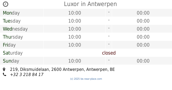
Luxor
Diksmuidelaan 219, Antwerpen
Cafe
read more
2.595 km
Kawa
Stadsplein 5, Mortsel
Cafe
read more
2.846 km
Cafe Romantica
30,, Amethiststraat 28, Antwerpen
Cafe
read more
2.899 km
Cafe en feestzaal Paroza
Bacchuslaan 67, Antwerpen
Cafe
read more
2.962 km
The crown Mortsel
Mechelsesteenweg 4, Mortsel
Cafe
read more
3.08 km
Café De Singel
Diksmuidelaan 34, Antwerpen
Cafe
read more
4.118 km
Duren
Turnhoutsebaan 211, Antwerpen
Cafe
read more
📑
all categories
Accounting
Administrative area level 1
Administrative area level 2
Airport
Amusement park
Aquarium
Art gallery
Atm
Bakery
Bank
Bar
Beauty salon
Bicycle store
Book store
Bowling alley
Bus station
Cafe
Campground
Car dealer
Car rental
Car repair
Car wash
Casino
Cemetery
Church
City hall
Clothing store
Colloquial area
Convenience store
Country
Courthouse
Dentist
Department store
Doctor
Electrician
Electronics store
Embassy
Finance
Fire station
Florist
Food
Funeral home
Furniture store
Gas station
General contractor
Grocery or supermarket
Gym
Hair care
Hardware store
Health
Hindu Temple
Home goods store
Hospital
Insurance agency
Jewelry store
Laundry
Lawyer
Library
Light rail station
Liquor store
Local government office
Locality
Locksmith
Lodging
Meal delivery
Meal takeaway
Mosque
Movie rental
Movie theater
Moving company
Museum
Natural feature
Neighborhood
Night club
Painter
Park
Parking
Pet store
Pharmacy
Physiotherapist
Place of worship
Plumber
Point of interest
Police
Political
Post office
Premise
Real estate agency
Restaurant
Roofing contractor
Route
Rv park, camping
School
Shoe store
Shopping mall
Spa
Stadium
Storage
Store
Subpremise
Subway station
Supermarket
Synagogue
Taxi stand
Train station
Transit station
Travel agency
University
Veterinary care
Zoo
sublocality level 1
sublocality level 2
sublocality level 3
↑